I came across this thread in my Hampton research and thought I would add some of what I was writing about because it provides some insight into this question.
The location of the original forge is somewhat in question, but there are several maps and references that help give us clues as to where it may have been.
Ascertaining the location of the furnace is a little easier and more definitive because of the remnants of the slag, however confirming the location of the forge is a little more difficult because it didn’t leave the same footprint. Further, after the iron era the whole area became a cranberry operation, which probably further obfuscated its location and probably changed the landscape.
Let’s start where it was likely not: According to Thomas Gordon’s map of 1828, the forge is downstream of the furnace, somewhere near where today the railroad tracks intersect with the Batsto. The Gordon map also indicates the forge and furnace were “in ruins”, which was also not likely correct at the time.
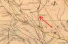
However, there are other sources that have different information. Historian Charles Boyer stated that the forge and furnace were some distance apart on two different streams. He also stated that the two different ponds on the Batsto and the Skit Branch were known as the “Furnace Pond” and “Forge Pond”, respectively, however there is no other information to back up those names. (Boyer, 1936) This same description of the two ponds is repeated in Family Empire in Iron, but is likely just a citation of Boyer. If we assume that both the Furnace and Forge use a waterwheel to power their respective bellows, it would make sense that the furnace would be located at the dam site of a pond. The 1849 map by J.W. Otley and R. Whiteford, provides us the best, most likely, visual on the location. It shows two ponds, one on the Batsto and one on the Skit. It also shows a structure labeled as a saw mill on the Batsto, and an unlabeled structure on the Skit. Since, to this day, there are still slag piles present at the location of the pond on the Batsto, we can deduce then that furnace was on the Batsto and that it is the forge at the other location, on the skit.
View attachment 18908
Using these historical maps, we can also see how the town of Hampton changed over the years. By 1849, the Iron Age at Hampton was coming to an end. The furnace was likely no longer in operation and the forge was likely struggling to compete. According to Family Empire in Iron, the forge operations ended around 1850. (Pierce, 1964). This is corroborated by the 1859 "New Map of Burlington County" by William Parry and George Sikes which now only shows a saw mill on the Batso, and no structure on the Skit.
View attachment 18910
Finally, the 1872 Topographical Map of the Southern Part of Burlington County also shows the two ponds, but now, no structures are indicated.
View attachment 18909