Retreat Preserve...A PBX Special Hike

Teegate

Administrator
Site Administrator
Sep 17, 2002
25,627
8,228
All,

Sometimes the members of PBX come up with idea's for hikes, and this one was designed by woodjin. Here is the edited text of todays outing which he aready discussed with us a few weeks back.


I mentioned this on the last PBX trip this past weekend .... the Retreat preserve owned by the Nj natural lands trust. What has drawn me to it is the fact that it is tucked away almost completely surrounded by private land. I am curious if it is hidden, pristine woods. Or has it been breached by the locals nearby. I am aiming to explore it next Sunday morning, the 23rd. It will be between two and three tough miles.
Jeff

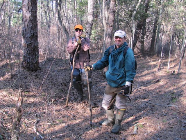
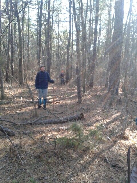
So this morning at 9AM we met along New Road and proceeded to the start of our hike at the far northern tip of the preserve. The preserve borders Leisuretown, New Road, Ridge Road, Retreat Road, and Route 70.

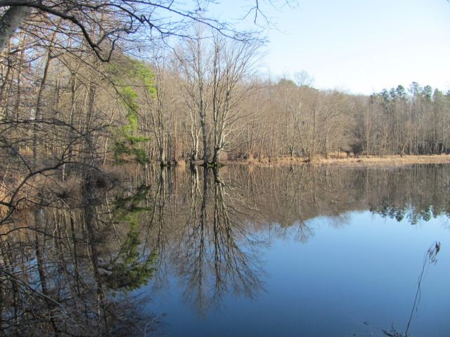
More on this lake later.
IMG_2046.JPG


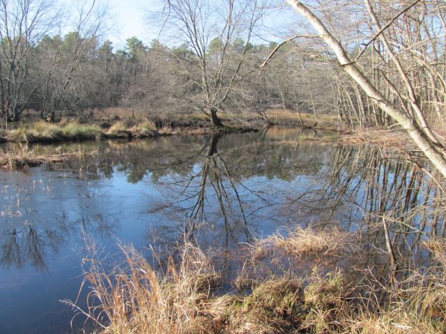
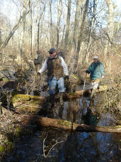
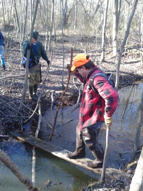
We traveled the west side of Friendship Creek and there were numerous canals which we had to cross.
IMG_2047.JPG

Unfortunately, our objective was to cross over Friendship Creek from the east to the west side and we were unable to do this. We were forced to travel much further than we wanted to and ended up in the heart of Leisuretown crossing the main bridge.

IMG_2048.JPG

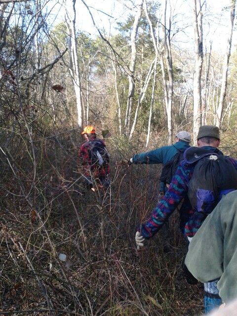
For a few second there it appears we were going to be confronted by a man in a pickup truck who quickly stopped on the bridge as we were about to cross. For some reason he continued on without speaking with us. After crossing the bridge we had to walk right through the back yards of a few homes while the owners were out raking leaves in the yard. We walked right by one older woman who never even knew we were there. I saw the man in the house next door looking out the window at us though. Apparently, nobody seemed concerned about 6 oddly dressed men passing through.

A few sections were full of brier and quite wet while others were just downright nice.

IMG_2049.JPG


IMG_2051.JPG


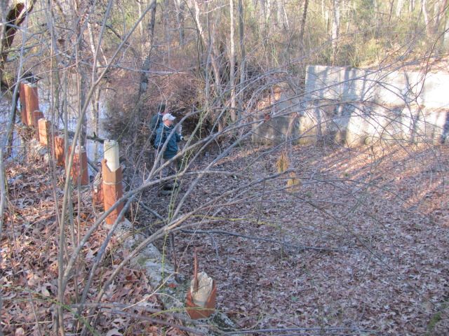
Most people don't know that this area has quite a bit of history to it. I was one of them. During our research of the area Bob noticed that the Retreat Cotton Factory was located in the area back in the early 1800s. He found the map showing it.

image007.jpg


Unfortunately, all remains of this huge factory and the homes that went with it are gone. In the early 1900's Wells & Crowshaw purchased the property for cranberry operations and built a hugh concrete dam that is still there and intact. It is extremely hard to get to and very few people even know it is there.

IMG_2056.JPG


IMG_2057.JPG


IMG_2058.JPG


IMG_2060.JPG

IMG_2061.JPG


IMG_2067.JPG


Our tracks
track.jpg


Read more about the factory which Bob found online.
http://articles.philly.com/1997-02-23/news/25536592_1_excavation-senior-citizens-industry

Jeff really came up with a good hike for us today. I was extremely impressed with the area and gave our hike today a 9.0. I would have gone higher but traveling around Leisuretown was not my idea of fun. I hate going near homes but we were committed once we could not cross the creek.
I want to thank Lost Town Hunter for passing along some of the information about the place after I contacted him tonight.
Guy
 

bobpbx

Piney
Staff member
Oct 25, 2002
14,193
4,292
Pines; Bamber area
..."Unfortunately, our objective was to cross over Friendship Creek from the west to the east side and we were unable to do this."

Hey, speak for yourself! :D

Good report Guy!
 

RednekF350

Piney
Feb 20, 2004
4,952
3,103
Pestletown, N.J.
Going on this excursion was a last minute decision for me and man, am I glad I went.
This was a very interesting piece of woods sandwiched between a rural portion of Southampton and the intensely developed Seizuretown age-restricted community. (Bob absolutely loved that place and will probably soon be a resident. :) )
Sadly, it is very evident that the local adjoining residents do not step foot into this preserve. It seems that they are very content to manicure their little lawns and commiserate with the neighbor's regarding their bleeding hemorrhoids.

Terrain was challenging and the remnants of a 100+/- year old cranberry operation were evident throughout the woods from one end to the other. It is staggering to ponder the work that went into clearing and then diking this over 500 acre tract in a time when earth moving machinery was predominately man and horse powered.

After reading the accounts of the Retreat Factory we were set on finding some remnant of that operation. Unfortunately, after learning a little more it seems that most remnants are long gone or beneath developed portions of Seizuretown.

Thanks for putting this together Jeff, a stellar hike.

Merry Christmas everyone !

Scott

Jeff and future age-restricted community resident Bob.
IMG_1530.jpg


The remnants of a substantial reservoir pond. Striking beauty, just out of view of the resident blue hairs.
IMG_1537.jpg


IMG_1526.jpg


A very big water control structure.
IMG_1531.jpg
 
  • Like
Reactions: John

Gibby

Piney
Apr 4, 2011
1,640
442
Trenton
It is interesting to see what is still hidden a few steps into the woods from a development. The faint grid pattern that can be seen in the top right of the aerial view of the route, is that part of the bog complex? From the looks of the water control structure the bogs had to be massive.
 

woodjin

Piney
Nov 8, 2004
4,341
327
Near Mt. Misery
It is interesting to see what is still hidden a few steps into the woods from a development. The faint grid pattern that can be seen in the top right of the aerial view of the route, is that part of the bog complex ? From the looks of the water control structure the bogs had to be massive.

the grid pattern you are seeing are the remains of a failed development plan from the 1920's. the faint grid pattern in the bottom left is are the remains of the 100 to 200 year old cranberry bog system. The 1930 aerial of the bog system showed an already overgrown ancient bog system. This might be one of the oldest around.

Jeff
 

Gibby

Piney
Apr 4, 2011
1,640
442
Trenton
Thanks Woodjin. I thought that the bogs wrapped around and followed the water way to the left and down, connecting to what was clearly visible in the lower part of the picture.
 
Gentlemen:

I am envious of your trip to Retreat! Not that I am in any shape to accompany the PBX crew, but Retreat and Birmingham have consumed some of my personal research time of late.

Writing in his 1931 work, Early Forges and Furnaces in New Jersey, Charles Boyer reports the following for Birmingham and Retreat Forge:

There is little authentic data on the origin of the ironworks at Birmingham, which were located on the north branch of Rancocas Creek, a few miles west of Pemberton. The place itself is frequently mentioned in the tax duplicates and is there called “Brumingham,” but no forge or furnace is specifically assessed at Birmingham in any of the tax duplicates so far located. Tradition says that it was built before the Revolution, but this statement is quite unlikely. From an old map recently located among the records in the files of the Burlington County Search Company, the forge is shown as located about four hundred feet south of the old road bridge across the raceway.
From the best information, it is believe that the Birmingham Forge was started about 1800 by Bolton and Jones, and that it contained four forge fires. In 1808, when the wood around the Birmingham plant was exhausted, they went further into the pine woods and set up two of the forge fires on a “feeder” of the south branch of Rancocas Creek, called Friendship Creek, naming the place Retreat, and later it was called Retreat Factory. The site of this forge is a little more than two miles southeast of Vincentown, just off the road from that place to Sooy’s tavern. In the assessor’s report for 1809, we find Retreat Forge specifically mentioned and, at the same time, learn that Bolton and Jones were taxed on four forge fires in two works. From this we can infer that the Birmingham plant may have still been in operation, especially as we find immediately following the names of Bolton and Jones, the name of a number of the head of families listed for assessment at a place called Brumingham. The records for the years 1810-1812 are lost, but for the years 1813-1814 John Bolton is named as the owner of Retreat Forge with two forge fires, no forges being taxed during these years at Birmingham. According to Gordon, a cupola furnace was in operation in 1832 at Birmingham. This was probably a later enterprise and was, likely, merely a foundry for making castings.
The site of the Retreat Forge is marked by distinct depressions in the ground around which can still be located many pieces of slag. Pieces of pig iron have, from time to time, been picked up along the road over which the raw material and finished products were carried. This road may still be traced through the tangled brush and thorns.
The writer recently obtained the back plate of a five- or six-place stove which was dug up in the vicinity of Retreat Forge. It shows some attempted decorations on the lower part of the plate, but otherwise is perfectly plain.

There are several errors and/or omissions in Boyer’s text, not the least of which is that he missed a newspaper advertisement in the 27 October 1803 edition of Poulson’s American Daily Advertiser, a Philadelphia newspaper:

1803 Ad.jpg
Boyer was right about one fact concerning Birmingham Forge: the forge was not there during the American War for Independence. Based on this advertisement, the partnership of Joseph Roberts and Joseph Bolton must have just completed building the forge, the mills, and the associated village when Roberts died. Note that the Birmingham operation and village is all described as either new or in complete repair.

With the death of his partner, Joseph Bolton formed a new partnership with a man named Jones—probably Benjamin Jones of Hanover Furnace fame. This partnership dissolved at some point in time and Bolton associated himself with Philadelphia merchant, Samuel E. Howell, who also had an interest in the forge at New Mills (present-day Pemberton). As Boyer notes, colliers had consumed the timber proximate to the Birmingham Forge, so Bolton and Howell established a new forge operation at Retreat. In a notice published in the 17 June 1813 edition of Poulson’s American Daily Advertiser, the partners attempted to sell their holdings at Retreat:

1813 Ad.jpg
Boyer wrote, “In the assessor’s report for 1809, we find Retreat Forge specifically mentioned and, at the same time, learn that Bolton and Jones were taxed on four forge fires in two works. From this we can infer that the Birmingham plant may have still been in operation, especially as we find immediately following the names of Bolton and Jones, the names of a number of heads of families listed for assessment at a place called Brumingham.” Since a portion of the advertisement above reads, “lower down on the same stream, there was a forge with four fires and water plenty,” the inference is that Bolton and Jones operated both of their forges on Friendship Creek in 1809 and had not continued operations at Birmingham. As with most furnaces and forges in the Pines, the Retreat Forge likely had a landing lot at Lumberton: “In New Jersey, seven miles from Lumberton, where there is a good landing and shallops run every week to and from Philadelphia.” Also note the statement, “It would be a good stand for a Cotton Factory, there being many children in the neighborhood.” Not only does the notice smack of child labor exploitation, but the two partners desire to replace the forges with the new wave of industry: a cotton mill. An 1817 road return uses the Retreat Factory as a survey or reference point, indicating that a cotton mill stood at the Retreat millseat. At some point in time subsequent to the placement of the 1813 advertisement, John Cushman formed a partnership with Howell and Bolton and proceeded to construct and operate a cotton mill. On 29 December 1819, the partnership between Samuel E. Howell, Joseph Bolton, and John Cushman, operating as Bolton, Cushman & Company, dissolved. Another advertisement in the same 12 January 1820 newspaper states, “The Cotton Manufacturing Business will in future be carried on by the Firm of John Cushman & Co. Retreat Factory.” Cushman continued cotton production until his death in July 1827 from apoplexy. He was 46 years old at the time of his death. According to a Congressional report on cotton manufacturers, a new cotton mill was built at Retreat in 1831 at a cost of $20,000—no small sum of money at that time!

On 27 March 1839, Samuel E. Howell died. His obituary reads,

“On Wednesday morning, 27th ult. At his residence, Retreat Factory, Burlington county, N.J., after a long and painful illness, which he bore with Christian fortitude, SAMUEL E. HOWELL, in the 69th year of his age, formerly a merchant of this city.”

Woodward’s 1883 history of Burlington County notes,

“…The cotton-mills at this place [Retreat] were operated until 1842, when the free-trade policy of Congress crippled and closed them up, with several others throughout the county. There is nothing left now to mark the location of the factory, except a few old pilings and the old dam and floodgates. But very few of the buildings connected with the factory remain.”

At some point, Trenton newspaper editor and local politician James T. Sherman acquired the property. In May 1853, he placed the following advertisement:

CHEAP COTTON MACHINERY.—The Subscriber offers at private sale, a quantity of Cotton Machinery, now in the Retreat Factory, near Vincentown, N.J., among which are seven threaders, with about seven or eight unused spindles; two Mules, of about two hundred spindles each; eight Carding Engines, and a full set of Cans; three speeders, one of which is a Counter Twist; one Picker and Apparatus; one Cutting Machine; two Shoe and three Turning Lathes; one Card Grinder; Blacksmith’s Tools; Vices and sundry old Machinery, Steel, Brass, Iron, &c.

Seven months later, Sherman ran this advertisement:

TO WOOLLEN MANUFACTURERS.—TO RENT—A Building 40 by 50 ft., five stories high, suitable for a WOOLLEN MILL, situated at Retreat, Burlington county, N.J., about twenty miles from Philadelphia, and within five or six miles of sloop and steamboat navigation. There is at the mill an abundant and very regular Water Power, and also a number of Dwelling Houses suitable for the Manufacturer and his workmen. This property is situated in a country neighborhood where labor and subsistence are cheap, and where considerable wool is grown. To a reliable manufacturer, with sufficient capital, the property would be rented on liberal terms. For further information, apply to JAMES T. SHERMAN, Trenton, N.J.

When he could not obtain someone to rent the factory building, Sherman placed this notice in February 1855:

James T. Sherman offers at private sale, the valuable water power & buildings at Retreat Factory, near Vincentown, with so much of the adjacent land as the purchaser may desire. Also the Retreat Tract, containing about 2,000 acres adjoining the above. Contact James T. Sherman at Trenton, N.J.

It unclear at this point in time whether the factory ever operated again as a textile mill, but it appears doubtful. Here is a view of Retreat—or New Retreat—in 1859:

Detail, 1859 Map.jpg

References to Retreat and New Retreat can be confusing, but it is my opinion that Retreat referred to the site of the original forge and New Retreat referred to the site of the new forges, but this is just an educated guess on my part.

On 27 November 1873, the following notice appeared in the New Jersey Mirror:

By virtue of an Order of the Orphans’ Court of the county of Burlington, made at the present (September) term of the said Court, the subscriber, Executor of the last will and testament of Mary Ann Howell, deceased, will sell at Public Sale, on Saturday, 6th of December, 1873, between the hours of 12 and 5 o’clock in the afternoon (to wit at 3 o’clock) upon the premises, certain Real Estate, whereof Mary Ann Howell, died seized, in the village of Retreat, in the township of Southampton, in the county of Burlington, to wit: all that certain Tract of Land, described in deed from Charles Bispham and wife to the said Mary Ann Howell, recorded in book S, 8 of deeds, page 532, &c., in the Clerk’s Office, at Mount Holly, containing One Acre and Sixty Hundredths of an Acre. The building is a good 2½ story Frame House, nearly new, of six rooms and is well located. Conditions at sale. Joshua B. Howell, Executor of Mary Ann Howell, dec’d. A. Flanders, Attorney. November 5, 1873.

Woodward notes,

The fine old mansion, occupied by the Boltons, Howells, and Cushmans, bears but little traces of its once noted genuine hospitality. The large tract of land once belonging with the place passed into the hands of Charles Bispham, of Mount Holly, who has cleared up a large farm on what was formerly known as the “Great Briar Swamp.”

The 1876 Scott atlas plate for Southampton Township depicts Bispham owning the “old factory” and 175 acres around it:

Detail, 1876.jpg

I need to conduct additional research, including title work, but this is my story of Retreat as it now stands.

Best regards,
Jerseyman
 
  • Like
Reactions: glowordz and oji

Teegate

Administrator
Site Administrator
Sep 17, 2002
25,627
8,228
Thank you for all of the information Jerseyman! I spoke with Lost Town Hunter the evening after the hike and he mentioned that Charlotte Cushman would spend time at the mansion when it was there. He also said in later years the dam we visited was built by Wells & Crowshaw for the cranberry operations there.

Guy
 

bobpbx

Piney
Staff member
Oct 25, 2002
14,193
4,292
Pines; Bamber area
Thank you kindly Jerseyman, for the good information. I wonder if the forges were above Ridge Road, but the Cotton Mill was below Ridge Road. That is what it seems looking at the maps. Our trip was south of the road. It is likely that Retreat was south of the road, and New Retreat north of the road?

I wonder also, how close to the water source does the factory have to be? I'd guess right next to it, otherwise the main power shaft would have to cover a greater distance.
 

Hewey

Piney
Mar 10, 2005
1,042
109
Pinewald, NJ
I will jump in a little late on this one. Thank you, Jeff. I was a great day in the woods!

Paul and Jeff in the pitch pine lowlands.
121223_0012.jpg


Scott, Bob, and Guy in a maple/gum swamp.
121223_0011.jpg


The first half of the hike was thick with the green haze.
121223_0010.jpg


Pitch pine lowland.
121223_0009.jpg


Jeff crossing with caution.
121223_0008.jpg


Jeff high in a large pine we found.
121223_0004.jpg


Jeff in the distance.
121223_0002.jpg


An area that was flooded at one time for the mill pond.
121223_0001-1.jpg


I hope all had a great Christmas! Have a safe and Happy New Year!

Chris
 
  • Like
Reactions: glowordz and John

Y-BUC-BILL

Explorer
Mar 9, 2007
129
26
I appreciate your pictures and reports of your hikes.If I was dumb enough to join you.You would need to get me out with a helicopter.The next best thing is reading about your adventures.I first got acquainted with Wharton Estate in the year 1942.
That was before the State of NJ purchased the Forest.Leeson Small was the caretaker of the Wharton Estate at that time.Leeson lived across from Atsion Lake.At that point and time people lived in the village of Batsto.I met Dave Amoto in the late 40's.That Piney was a world of infomation.He put us on a lot of deep rutted two trackers.Said they were old stagecoach roads.I spent may days riding dirt bikes on what is now the Wharton State Forest.Back in the 40's the Forest was seldom used.During Deer season their was a lot of activity.A lot of deer camps were built in the forest.Others set up tents.They were all demolished when the State bought the forest.I am glad you girls and guys are using the Forest.Keep the stories comig.Appreciate it.
 
  • Like
Reactions: Trailwalker
Thank you kindly Jerseyman, for the good information. I wonder if the forges were above Ridge Road, but the Cotton Mill was below Ridge Road. That is what it seems looking at the maps. Our trip was south of the road. It is likely that Retreat was south of the road, and New Retreat north of the road?

I wonder also, how close to the water source does the factory have to be? I'd guess right next to it, otherwise the main power shaft would have to cover a greater distance.

Bob:

My sense is that the “new” forges stood above Ridge Road and the “old” forges stood where Cushman built the cotton mill. Your assessment of Retreat vs. New Retreat sounds right, but I really need to conduct further research before I can state so with any certitude. Although it does not appear on the maps, the cotton mill must have had a raceway either running beneath it, where it received power from hydro turbines, or a raceway alongside the building, receiving its power from a mill wheel. There is not doubt that the mill stood immediately adjacent to its power source. Longer shafts mean loss of horsepower. Here is a circa 1845 map that provides a different view of “Retreat Factory:”

Cotoxen Township 1845.jpg


Best regards,
Jerseyman
 

bobpbx

Piney
Staff member
Oct 25, 2002
14,193
4,292
Pines; Bamber area
That is a very interesting map Jerseyman. Thanks for posting it. It looks like the mill may have been a lot closer to the road than I thought.

Imagine having to tell people you were born in Turkeytown! :p
 

pineywoman

Explorer
Aug 24, 2012
427
48
I go "off duty" at least once or twice a week. I'd be solo or arrange it that way. I will never post anything on Yummygal. A lot of stuff I don't post because I hold the pines sacred to me.
 

bobpbx

Piney
Staff member
Oct 25, 2002
14,193
4,292
Pines; Bamber area
Just how does one find out about these PBX hikes?

We are a tight group. We keep it that way because we all get along and we are all zealous about these woods and what we do. It definitely makes a 6-7 hour experience that much more enjoyable. However, once in awhile we open a trip up to anyone. The last 3 or 4 times we did that though, we only got one person that came out, and that was on only one of those open hikes!

I hear some interest, so I'll probably open the next one up to anyone on this forum board. However, having more than 10 or 12 is not enjoyable. We tend to get too strung out and it puts a damper on the wilderness experience. If that unlikely event happens, I'll do something to limit it.
 
Top