CompeGPS - for Mac and Windows

Boyd

Administrator
Staff member
Site Administrator
Jul 31, 2004
9,547
2,806
Ben's Branch, Stephen Creek
Interesting software that I just found - especially for Mac users since there is not much GPS software available. Download here. You can register for the free version by just entering your name and e-mail, which I did. It says all the features work for 30 days.

http://www.twonav.com/en/support/downloads

The user manual is available here:

http://manual.twonav.com/manual/land_air_76_en/wiki_land_air/

I only played around briefly with the Mac version. It seemed to open my LIDAR .kmz maps fine (see https://forums.njpinebarrens.com/threads/lidar-enhanced-aerial-views.10340/page-3#post-124283)

I was not able to get the software working with my Bluetooth Garmin GLO GPS however. This might be a Mac-specific issue, not sure. Also couldn't get it working with my Montana 600 over USB. Will look into this a little deeper in the future. But this could be handy software even without GPS capabilities, because it appears to open many GIS file formats.
 
Last edited:

Teegate

Administrator
Site Administrator
Sep 17, 2002
25,641
8,249
Could not get a free license. It asked for a password.
 

Boyd

Administrator
Staff member
Site Administrator
Jul 31, 2004
9,547
2,806
Ben's Branch, Stephen Creek
That dialog box was in a foreign language and confused me too. You have to choose the other option at the top of the page (the button on the right, not the default on the left). The default assumes you already have an account with them. If you click the one on the right, it just asks for your first name, last name and e-mail (all in a foreign language again). You also have to choose one of the options of how you will use it.

When I did this, it immediately unlocked the program, it did not send me any e-mail or anything.
 

Teegate

Administrator
Site Administrator
Sep 17, 2002
25,641
8,249
I got it to work but the program has issues with my Apple mouse. This is not new as many programs in Windows do also. One touch of the mouse sends the program zooming in or out so far I can't find my way back.
 

Teegate

Administrator
Site Administrator
Sep 17, 2002
25,641
8,249
It has a feature that was on a program I used for years until Apple eliminated support for it. I can take a photo or old map I have and using known GPS coordinates I can add the map to the program and pick points on it and have a general idea where they area. I found many a stone that way and this may be helpful. It just looks like it is going to take some time to master just like it did using Google Earth.
 

Boyd

Administrator
Staff member
Site Administrator
Jul 31, 2004
9,547
2,806
Ben's Branch, Stephen Creek
I have always used a cheap Windows mouse on my Mac (or the built-in trackpad, which is really nice on the MacBook Air). worked fine in CompeGPS. Do you have a "Magic Mouse"? I hate those things, my Greek friend has one and it always gets away from me, LOL.
 

Boyd

Administrator
Staff member
Site Administrator
Jul 31, 2004
9,547
2,806
Ben's Branch, Stephen Creek
I can take a photo or old map I have and using known GPS coordinates I can add the map to the program and pick points on it

I think you are talking about calibrating an image (also called georeferencing). That is handy when needed, but it's also nice to download imagery that is already georeferenced if possible. :)
 

Teegate

Administrator
Site Administrator
Sep 17, 2002
25,641
8,249
Yes, I have the Magic Mouse. I have found I like it the best because of the quick zoom and page scroll but the zooming in an out is a problem.

The survey maps I use are not georeferenced so this program may work well. I will just need time to master it. I just got use to Google Earth so it may be hard to switch now.
 

Boyd

Administrator
Staff member
Site Administrator
Jul 31, 2004
9,547
2,806
Ben's Branch, Stephen Creek
The survey maps I use are not georeferenced so this program may work well.

To me, what stood out about this software is all the file formats it can use. Not many (if any) other Mac programs that can open things like Shapefiles. However, I didn't look very closely at the difference between the paid and free version. It's hard to tell since everything will work for 30 days on the free versions.

You should check this out if you plan to really use this software (or else get all your work done in 30 days :) ) because it costs 90 euros to purchase the full version. Of course, the way things are going with the Euro, 30 days from now it might be pretty cheap. :D
 

Teegate

Administrator
Site Administrator
Sep 17, 2002
25,641
8,249
Thanks Boyd for the info. I think I will just stick to Google Earth for what I do.
 

Boyd

Administrator
Staff member
Site Administrator
Jul 31, 2004
9,547
2,806
Ben's Branch, Stephen Creek
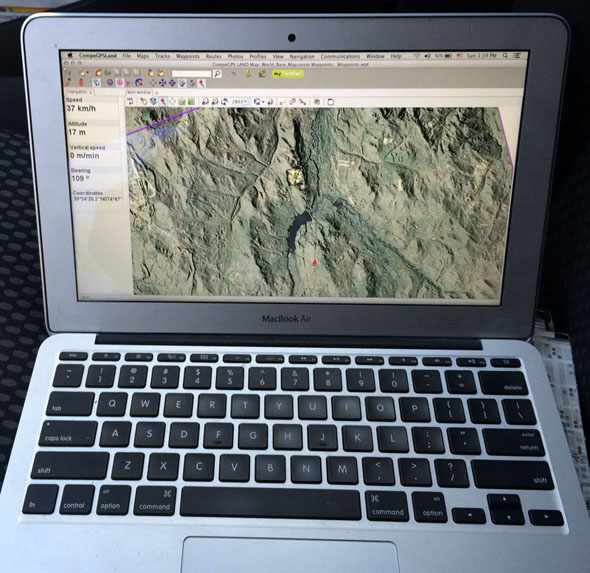
Just for fun, I was finally able to get this program talking to my Garmin GLO bluetooth GPS. Here it is with my "LIDAR in the Pines" map on a quick test drive. I have the 11" MacBook Air which is quite a small laptop, but still totally impractical to use in my car. So I'm done with this program, but it's nice to see that someone has finally introduced a full featured app on the Mac. :)

compeGPS_Mac.jpg
 
Last edited:

Boyd

Administrator
Staff member
Site Administrator
Jul 31, 2004
9,547
2,806
Ben's Branch, Stephen Creek
So I'm done with this program

Well… I lied. Did some more reading and learned that I can use the Mac program to send my maps to the iOS TwoNav app (they also have an Android app).

https://itunes.apple.com/us/app/twonav-gps-premium/id346996240?mt=8

https://play.google.com/store/apps/details?id=com.compegps.twonav&hl=en

They have a free and paid version of this app, and (like everything else about their software) I'm still confused about the differences. Will skip the details, but after a bit of screwing around I was able to send a smaller test version of "LIDAR in the Pines" to the app running on my iPhone. I ended up buying the full version, since it was only $6, not sure if that was absolutely necessary (although it has a lot of nice configuration features).

Anyway, the interesting thing here is that I *think* I can offer a version of LIDAR in the Pines that will run in TwoNav on your iOS or Android device. Need to do a lot more tests, but I *think* such a map wouldn't have the limitation of the Garmin Custom maps. In other words, you could load all of the Pines on your phone or tablet and also get a much higher quality display. This *might* work on the free app without purchasing anything. Or you might have to buy the $6 app. I also *think* you can transfer the map from your computer to the phone using a free FTP client on Mac or Windows without buying or installing the CompeGPS program. But all of this needs more study.

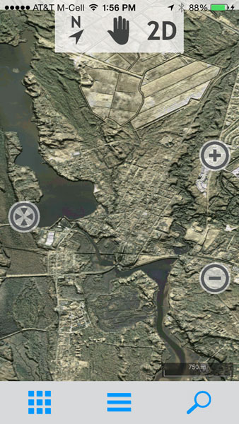
Will post more about this later, as time permits. Will also post to my thread about LIDAR satellite imagery. Here's a screenshot of my first test in the TwoNav app on my iPhone 5s. :)

twonav2.jpg
 
Top