All Unpaved Roads in Stokes State Forest PERMANENTLY CLOSED

Badfish740

Explorer
Feb 19, 2005
589
44
Copperhead Road
As per my conversation with a representative of the park about 5 minutes ago. This was done completely in the dark of night as there is no mention of it on their website, nor even a map available of what is still accessible. I'd like to say that I'm shocked by what the Division of Parks and Forestry is doing, but I guess I'm really not at this point. Just last May I led a group of friends who had never been to the area before on a two day tour of Stokes and the Water Gap and had mapped routes to a couple of old farmsteads long reclaimed by the forest that will now require miles of hiking to get to. Not to mention the difficulties this will present for hunting this fall. I'm almost afraid to see what the National Park Service might do on their adjoining lands. Crater Lake, quite possibly the finest swimming hole in NJ is located at the very end of a 3 mile long dirt track and is the first lake my daughter ever swam in. No lifeguards, no "designated swimming area," and no crowds-you can even *GASP* legally drink a beer there since it's federal land. Access to Crater was blocked for two years after Hurricane Irene and the NPS took forever to fix the roads-I was amazed when they finally did.

I think at this point none of us have any reason to believe that Bass River, Lebanon, and other State Forests won't be next, provided the roads haven't been closed already without any notice to the public whatsoever. Getting back to Stokes, I kept my composure on the phone with the representative from the Forest office, but was pretty clearly stating my displeasure. She of course, stated that, "the fourwheelers" were the reason for the closure and that the trails were still accessible for hiking and biking. When I reiterated what a shame it was that the roads were closed and that the fact that no notice was given to the public was not very transparent, she pressed me "Well, do you want to go off-roading?" in an accusatory tone. I explained to her that I've been to Stokes many times, driven my truck to remote parts of the forest, parked it, and embarked on a hike from there, fished out of the way streams and ponds, and just used my vehicle to support my outdoor activities rather than just tearing up the land, but it's clear to the Division, all motorized vehicle use is considered to be nefarious and destructive in nature.
 
Last edited:

Badfish740

Explorer
Feb 19, 2005
589
44
Copperhead Road
I'm pretty sure that one of the major routes to get to Buttermilk Falls up at Stokes is mostly unpaved.

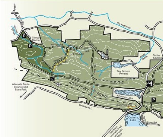
Mountain Road is mostly unpaved, but luckily the entirety of it is located within the Delaware Water Gap (as are the falls themselves)-the road actually forms the border between Stokes and DWG at times, but it is located on federal land-Mountain Road is the road that runs along the top of the map along the Flatbrook River. The green areas are Stokes property-the roads in the center of the map (Dimon, Coss, Woods, Shay, and Brink) are all currently closed.

Stokes%20Map_zpslw3cw4oy.jpg
 

46er

Piney
Mar 24, 2004
8,837
2,143
Coastal NJ
I can't make it out from your map, but it appears Tillman Ravine is inaccessible? Have you checked the WMA's; Flatbrook, Walpack? I seriously doubt the feds will be closing anything.
 

Badfish740

Explorer
Feb 19, 2005
589
44
Copperhead Road
I can't make it out from your map, but it appears Tillman Ravine is inaccessible? Have you checked the WMA's; Flatbrook, Walpack? I seriously doubt the feds will be closing anything.

Tillman is also still accessible as Struble (which becomes Brink-I erroneously listed that one as closed) is paved along its entire length. I haven't been out to the WMAs lately, but I have not heard of any plans to close major thoroughfares on either of them. On both Walpack and Flatbrook-Roy there have been longstanding closures of "loops to nowhere" off of the main roads that were created by trailblazing troublemakers looking for mud holes through the years, but again, the main roads remain open. As far as the federal land is concerned, they've done an awful lot of road closures that have been in place for a long time. John Donahoe, the Superintendent, was Superintendent of Big Cypress National Preserve before he was assigned to the DWG and he picked a lot of fights with hunters, anglers, and outdoor enthusiasts in general with motorized vehicle bans and road closures down there. Many of the long established roads in the DWG have been closed, most notably Woods Road, at the boundary between Stokes at the DWG. This is a road that shows up on topos going back at least 50 years.
 

46er

Piney
Mar 24, 2004
8,837
2,143
Coastal NJ
Yes, the feds closed roads some time ago and again after those bad storms. What I was wondering was if the feds were closing any in concert with the state.
 

Badfish740

Explorer
Feb 19, 2005
589
44
Copperhead Road
Yes, the feds closed roads some time ago and again after those bad storms. What I was wondering was if the feds were closing any in concert with the state.

They are a strange animal and its hard to tell what their motivations are sometimes. Skyline Drive (which leads to Crater Lake) and sections of Old Mine Road were closed for almost two years after Irene, but they said it was due to budgetary constraints. I never believed that Skyline would reopen, but it did, and they actually did a nice job on the road.
 

46er

Piney
Mar 24, 2004
8,837
2,143
Coastal NJ
I plan to be up their in October for our annual trout hunt, that is if we get some rain. I guess I should bring some comfortable hiking boots.
 

Badfish740

Explorer
Feb 19, 2005
589
44
Copperhead Road
I'm assuming you fish the Flatbrook? Very little, if any, of the Flatbrook flows through Stokes. Most people believe that Stokes is much larger than it is due to the fact that there is very little to indicate where DWG property begins and Stokes ends and vice versa. Again, if you look at the map you'll see that the Flatbrook flows through the cream colored area, which is DWG/WMA property, not Stokes. There are actually more than a few access points to it off of Mountain Road. Have you ever stayed at Ken's place (Bear Creek Campground)? It's a popular spot in the Spring as the Flatbrook flows right through it. It used to be called Walpack Family Campground/Mrs. Bs before Ken bought it.
 

46er

Piney
Mar 24, 2004
8,837
2,143
Coastal NJ
I do fish the FB, mostly the portion in Stokes, and the smaller lesser known streams, most of them on fed land. Never stayed at that campground, most of the time at Worthington, I get a discount ;)
 

Badfish740

Explorer
Feb 19, 2005
589
44
Copperhead Road
I think you're right.

It really depends on how you access it. I, along with most people here who come from the south, would go this way, coming up the ridge from Blairstown/Hardwick:

https://goo.gl/maps/CmAO3

This is all DWG property so there should be no issue. Coming from the north, however, through Stokes, would likely be a problem. I've not personally been there yet, so I can't verify, but according to what the person I spoke with on the phone said, Struble should be blocked at the point at which it turns to dirt, which is somewhere west of Deer Lake. In fact, I'd be pretty pissed if I was one of the folks who lived there-there are about 6 or 7 residents, who seem to be year rounders for the most part.

https://goo.gl/maps/xQoPI

Edit: Nothing mentioned on the Stokes website, either.

Which should make folks wonder where else road closures have occurred/will occur with no warning whatsoever.
 
Top