Around Atsion And Other Things

woodswench

New Member
Jan 6, 2012
6
0
75
Thanks. Now I need to figure out how to upload an avatar.

My trips to the Pine Barrens are my favorite recreation, but since I don't have 4WD at the moment, I'll be gravitating more towards Lake Oswego this summer. Love the "waterfall" on the other side of the lake.

Many (many) years ago I used to go to a place not far from there called "the cattle crossing", which was a sunken bridge where people would stand around watching canoers get hung up on it and dump. Does anyone here know if it's still there?

We also go a lot to the "Beaver Pond", where my two little dogs have learned to body-surf over the beaver dam when the water level is high enough.

I'd also like to find a back way to Jemima Mount, to avoid that huge puddle.
 

Teegate

Administrator
Site Administrator
Sep 17, 2002
25,653
8,264
Thanks. Now I need to figure out how to upload an avatar.


At the top right of this page just below the search field you will see your screename. Slide your mouse over it and a list will display with the word Avatar in it. Choose that and upload.

Portions of the far side of Oswego is private so be careful.

That puddle is a problem but I have been able to go around it in my car. However, that was a little while ago so that may not be possible now.

Guy
 

woodjin

Piney
Nov 8, 2004
4,341
327
Near Mt. Misery
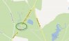
Guy, if you zoom out from the corn fields, you'll note two things....one is that area is a MAJOR headwater source for the Batsto River. Secondly, you'll note why we are seeing more and more non-native plants along the Batsto. That area is polluting the Batsto with fertilizers, and probably pesticides.

Bob, that is the Green limb, also referred to as the Horse Limb. When you cross over it on Buttersworth Bogs road you see a lot of phragmites. There also appears to be some other non native plants but I couldn't identify them off the top of my head.
 

woodswench

New Member
Jan 6, 2012
6
0
75
OT: I was going to take a friend to Apple Pie Hill today but we didn't make it. Is it still open to the public......haven't been there in years. The last time I was there years ago, there looked like there was a lot of vandalism (people throwing old pc's off the tower). I want to go in winter/early spring because the chiggers there were the worst I've encountered in all my trips to the pines.
 

Teegate

Administrator
Site Administrator
Sep 17, 2002
25,653
8,264
It is open but you can't drive to the top anymore. I would suggest you park before you get to it along the side of a road and walk. If you go around the curve and start up the hill you have to stop at a gate. If there are multiple cars or someone comes up behind you it is tough to turn around. I almost got stuck in a rut there recently.

Guy
 
Apr 6, 2004
3,613
556
Galloway

imkms

Explorer
Feb 18, 2008
587
224
SJ and SW FL
Many (many) years ago I used to go to a place not far from there called "the cattle crossing", which was a sunken bridge where people would stand around watching canoers get hung up on it and dump. Does anyone here know if it's still there?

I'm not sure if this is the "cattle crossing", but your description does match it.

1875-669fcdbf4b6745113d7066b02c7d21f5.jpg
 

Attachments

  • map.jpg
    map.jpg
    22.4 KB · Views: 247

woodswench

New Member
Jan 6, 2012
6
0
75
That dam washed out back in 2005. It was a great place to sit on a hot summer day.
What a shame. On a hot summer Sunday, there'd be whole families standing around in the water just to watch the canoers get stuck - or dump.
Free entertainment for all.
 
Top