Ballanger Creek

dogg57

Piney
Jan 22, 2007
2,912
377
Southern NJ
southjerseyphotos.com
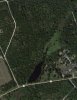
Winding through a dead and submerged cedar forest, the slightly spooky Ballanger Creek straddles the border between Little Egg Harbor and Bass River townships. It was once dammed as a pond and the site of a gristmill and then a sawmill, when it was known as the French Farm. But those days are gone. Now it offers a pleasant hike through fields and woods and along that spooky creek.
The Conserve Wildlife Foundation of New Jersey purchased the eight acres in the 1990s; since then it was incorporated into the surrounding Bass River State Forest. The Ballanger Creek Habitat Enhancement site is managed jointly by the state forest and the CWF. On Sunday, CWF Project Manager Ben Wurst and a handful of volunteers came out to do trail maintenance as a precursor to National Public Lands Day, Sept. 29.(
— Pat Johnson
http://thesandpaper.villagesoup.com/news/story/ballanger-creek-habitat-site-opened-for-hiking/901492
 

dogg57

Piney
Jan 22, 2007
2,912
377
Southern NJ
southjerseyphotos.com
Imagine this.I was making plans to visit this area but had no idea they were making a tourist attraction of it.Are there hiking trails?
Hey Al ,Only thing I can tell is from the paper said. Just drove past there the other day and could not stop.(Wurst said when Hurricane Irene came through a year ago, the earthen and beaver dams were overpowered by rainfall and collapsed, and the impoundments are no longer pond-like, so are unable to support fishing or kayaking. “It’s returned to more of a creek, and we may let it stay that way. It depends on what the state wants to do,” said Wurst. The hiking trails are short and doable, and there is parking within the site that is just off Route 9 across from Jericho Road.)
 

manumuskin

Piney
Jul 20, 2003
8,643
2,559
60
millville nj
www.youtube.com
thats ashame the dams collapsed.on birds eye the upper section of pond looked to be full of water and cedar skeletons and would have had nice reflection shots.guess the water is all gone now.
 

Teegate

Administrator
Site Administrator
Sep 17, 2002
25,850
8,554
Al,

We will be going there this stone hunting season :)

Guy
 

stizkidz

Piney
May 10, 2003
1,044
8
Tuckerton
Sorry to resurrect an old thread...

Please see attached pic. Is the area next to the open section of the creek private property? It is not shaded green on the map to indicate it is part of the state land. I am referring to the area between the development and the creek. Old maps indicate it was once farmland.
 

Attachments

  • $62CC30856D595FA2.jpg
    $62CC30856D595FA2.jpg
    94.6 KB · Views: 220

manumuskin

Piney
Jul 20, 2003
8,643
2,559
60
millville nj
www.youtube.com
went on a stone hunt there once.The land west (left) of the creek is state over to the dirt road and east of the creek is state further north upstream but the land between the development and the creek i believe is private.I could send or post a track boundary of the property but it may take me awhile to find it.Guy is better organized and could probably find it faster.I remember the state line does cross over (east) of the main dirt road that heads north up the east side of the creek just off of your pic but it doesn't go far past the road and then turns north and then west back to the beginning.The corners are still flagged and painted orange.I saw an occasional posted sign but they weren't obnoxiously present except the northwest corner was kind of heavily posted by a hunting club.
 

Teegate

Administrator
Site Administrator
Sep 17, 2002
25,850
8,554
The property in question (between the development and the creek) is owned by Arden & Patricia Myers (Block 281 lot 5.01). The lake or bog is owned by Toll Land XI Limited Partnership ( Block 281 lot 4) (Deed Book 1214, Page 1147). The property to the left of the lake or bog is owned by the state of NJ but I caution you that there appears to be another lot in between the state land and the lake or bog and I don't have that info. It may be state or it may not be. I have the complete survey south of that location which shows in the upper section this area in minor detail.

With all of this said the survey I have is from 2007 so the information may have changed.

Guy
 

Teegate

Administrator
Site Administrator
Sep 17, 2002
25,850
8,554
Are you referring to the development to the left or right of the water?
 

Teegate

Administrator
Site Administrator
Sep 17, 2002
25,850
8,554
I was thinking you were referring to the right development. In any event, this shows the land to the left of the stream is state.

IMG_1084b.jpg

Guy
 
Top