Cedar Bridge Hills Development

Teegate

Administrator
Site Administrator
Sep 17, 2002
25,602
8,177
Have you ever wondered what was going on here at 72 and 539 by Skippers Seafood?


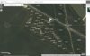
Well, it was a planned development called Cedar Bridge Hills circa 1955 developed by Adamston Land Company.

Here is the map. Click to make larger or download.

Cedar Bridge Hills.jpg
 
  • Like
Reactions: Boyd

Teegate

Administrator
Site Administrator
Sep 17, 2002
25,602
8,177
I noticed something is now down the end of one of the roads there. It was not there three years ago. It appears it may be on state property.


state.jpg
 

Teegate

Administrator
Site Administrator
Sep 17, 2002
25,602
8,177
If you are referring to the photo and the link location I don't know. I put the red line there and I believe from the info I have it is on state property. I may be wrong.
 

RednekF350

Piney
Feb 20, 2004
4,944
3,080
Pestletown, N.J.
Wow. The entire development is still officially mapped and the the individual lots are owned by a wide mix of people from all over the State , Florida and elsewhere.
 

Attachments

  • skipper.JPG
    skipper.JPG
    257.4 KB · Views: 159
  • Like
Reactions: Boyd

Teegate

Administrator
Site Administrator
Sep 17, 2002
25,602
8,177
I just used Google earth to see from the road. The place I was reffering too was the sandy area just off the road a little more west


Jessica and I went there when the buildings were still there. The one in the back was creepy. I am looking for my photos but can't find them yet.
 

Teegate

Administrator
Site Administrator
Sep 17, 2002
25,602
8,177
Jessica and I went there when the buildings were still there. The one in the back was creepy. I am looking for my photos but can't find them yet.


Here they are. It had swings and kids things laying around such as crayons and Disney stickers. Not a place where kids should be playing.

IMG_0951a.jpg


IMG_0943a.jpg
 
  • Like
Reactions: Wick and Boyd

Teegate

Administrator
Site Administrator
Sep 17, 2002
25,602
8,177
Wow. The entire development is still officially mapped and the the individual lots are owned by a wide mix of people from all over the State , Florida and elsewhere.

We went back there with Jeff after a PBX hike once. There are ruins back there of an old house I believe. I will have to look for those photos also.
 

Teegate

Administrator
Site Administrator
Sep 17, 2002
25,602
8,177
Jessica and I visited the structure this morning shown above in post 3 that is at the end of the road. This was just before the blizzard hit us. It is certain the structure was on state property. Notice I said "was on."

DSC_1012a.jpg


They even had sprayed foam in all the seams to keep it air tight.

Anyway, we were able to find two of the original monuments mentioned on the map shown above. I have an old deed for the state property there, which is now Bass River North, and that will allow me to now find a possible stone or other monuments near the Boy Scout property on the red road.

DSC_1014a.jpg
 

Attachments

  • DSC_1014a.jpg
    DSC_1014a.jpg
    333.7 KB · Views: 123
  • Like
Reactions: Boyd and bobpbx
Top