
Checking in
- Thread starter MarkBNJ
- Start date
You are using an out of date browser. It may not display this or other websites correctly.
You should upgrade or use an alternative browser.
You should upgrade or use an alternative browser.

Wow Mark, I didn't realize the problems were so bad in your area. Glad you are back up and running.
I was asked about you tonight by a member of this site who said you were AWOL and I was going to write you directly to see if I could contact you.
I always resisted getting a smartphone because I spend my day surrounded by computers, and the luddite in me didn't feel like he needed another one strapped to his hip. I have now revised my opinion
") .
.Hey Ben, missed this when it was first posted. I haven't been up to the gap since the storm, but I know a couple people who have and they didn't report much damage. Hoping to get up there myself shortly after the new year.
I would never mind a passenger, but unfortunately I haven't had the time to make it back up there. We should organize something in the early spring before the weather gets too warm and the bugs come out. There are a lot of sites I would like to revisit.
I ended up heading there this last weekend. It was a perfect day - the weather was wonderful and you could smell flowers blooming and spring in the air. There were a fair amount of people out, but it seems like they were mostly south of Calno.
I was sad to see that the Van Campen homestead burnt down.

Farmhouse Ruins. Calno, NJ. by benruset, on Flickr
The same place on Christmas 2011:

IMGP1985 by benruset, on Flickr
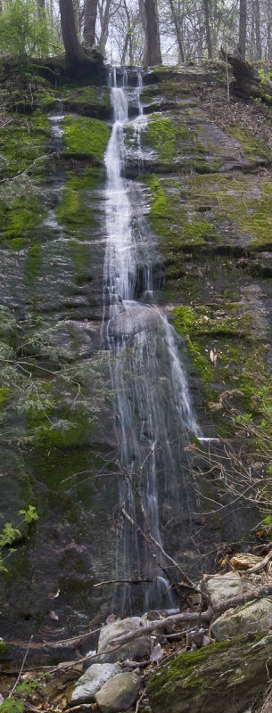
I love photographing waterfalls:

Buttermilk Falls. by benruset, on Flickr
Abandoned buildings galore.

Tin Roof -- Rusted. by benruset, on Flickr
And it was great that the entirety of the Old Mine Road is now open. I finally got to see the Van Campen Inn.

Van Campen Inn. by benruset, on Flickr
I was sad to see that the Van Campen homestead burnt down.
Farmhouse Ruins. Calno, NJ. by benruset, on Flickr
The same place on Christmas 2011:
IMGP1985 by benruset, on Flickr
I love photographing waterfalls:
Buttermilk Falls. by benruset, on Flickr
Abandoned buildings galore.
Tin Roof -- Rusted. by benruset, on Flickr
And it was great that the entirety of the Old Mine Road is now open. I finally got to see the Van Campen Inn.
Van Campen Inn. by benruset, on Flickr
Nice photos Ben. They bring back memories of my younger days wandering that area when I lived in the northern part of the state. Most of my time was spent hunting grouse and flyfishing for trout but the history bug bit me just before I moved here in the early 80s. There are many spots I'd love to revisit now. I did manage to get a tour of the Van Campen Inn once when I happened to pass by while it was open to the public. There's also in interesting old lime kiln just off Old Mine Rd. that I mistook for an iron furnace the first time I saw it. I'm starting to think I need to put aside a weekend for a camping/exploration trip up there.
Very nice Ben! I was up there a few weeks ago myself and was happy to see that the road to Crater Lake is open again.
I had meant to check out Crater Lake, but I ended up going north along the Old Mine Road far enough that I didn't want to backtrack all the way. Do you have any pictures of the lake?
We'll be headed up there some time over the next 2 weeks hunting for waterfalls and ruins. Child's Park will be opening 5/25 and it will soon be Rhododendron blossom time 
I had meant to check out Crater Lake, but I ended up going north along the Old Mine Road far enough that I didn't want to backtrack all the way. Do you have any pictures of the lake?
I hiked up from Fairview Lake last year when the road was closed, took the Appalachian Trail and then followed the old roads around Crater Lake. The Northwest end has some nice cliffs IIRC. There's a picnic area at the East end that isn't anything particularly special. Thought I tooks some shots but I can't find them.
Looking quickly through the pictures on my phone, here are a couple other lakes in the area however. Lower Yards Creek Reservoir, from the Appalachian trail: http://maps.njpinebarrens.com/#lat=41.00710719275276&lng=-75.01876831054688&z=14&type=topo&gpx=
And this is Catfish Pond: http://maps.njpinebarrens.com/#lat=41.03951673214601&lng=-74.99610900878906&z=15&type=topo&gpx= I hiked up there, taking the Copper Mine trail from Old Mine Road. I like that trail a lot - it will show you just how out of shape you really are.
But you can also get to Catfish Pond in your car from Camp Road on top of the Mountain. There's a nature trail that leads back to the lake.Another cool place is Sunfish Pond. See chapters 1 and 2 in Beck's "Roads of Home" where he talks about his quest to go there. I took the Garvey Springs trail up there last year and - man - that is a workout for those of us who are used to walking around the pines! But just take your time and you will get there and be rewarded by a nice hike around the lake.
Are there any nice RV parks in the area?
There is the Bear Creek Campground on 615 near the Walpack-Flatbrook Rd merge, never camped here. And Worthington SF, which really isn't in the immediate area, but they take RV's.
You may already know of this site, all kinds of great info for that part of the state;
http://www.njskylands.com/
I stay at Bear Creek anuually to fly fish the Big Flatbrook. Nice campground, decent rates, and right in the heart of the parks and forests. They allow alcohol too, unlike the state parks (if you're looking for that). Owners name is Ken and he's a state trooper, so its a pretty safe campground. Walpack Inn is less than half mile up the road and has great dinners, lunches, and drinks in a rustic environment. Get a decent map and directions if you head up that way, as I always run into lost new-comers and some areas arent GPS friendly.
some areas arent GPS friendly.
Do you mean that the map doesn't have the roads, or that you can't get a signal? I've never had signal problems. Using a topo map should give you most of the roads. My NJ map has coverage there (although I am currently improving that for the next version): http://www.gpsfiledepot.com/maps/view/294/
That map will work with all Garmin devices. If you have a recent Garmin handheld, this will give you a scan of the USGS 24k Topo map of a portion the Delaware Water Gap area: http://www.gpsfiledepot.com/maps/view/234/