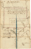
I believe that wetland is called Maple Swamp along Maple Swamp Branch. I'd love to know the name of this spung there (at crosshairs)—
TO: Jonathan Risley
8 Dec 1806
FROM:
SURVEY AND MAP. 225.5 acres. Maple Swamp Branch; On the new road to Philadelphia; Great Egg Harbor Township; Gloucester County. Surveyed for 356 18/100 acres; Remaining for 225 1/2 acres with exceptions for previous surveys.
OTHERS NAMED: Matthew Collins (Deputy Surveyor) (Signatory); Erasmus Felter (Owner of adjoining land); Edmond Iliff (Owner of adjoining land); Jeremiah Risley (Former owner of land); John Tilton (John Tilton's road; Owner of adjoining land); William Wital (Owner of adjoining land)
Matthew Collins (Deputy Surveyor) (Signatory); Erasmus Felter (Owner of adjoining land); Edmond Iliff (Owner of adjoining land); Jeremiah Risley (Former owner of land); John Tilton (John Tilton's road; Owner of adjoining land); William Wital (Owner of adjoining land)
Matthew Collins (Deputy Surveyor) (Signatory); Erasmus Felter (Owner of adjoining land); Edmond Iliff (Owner of adjoining land); Jeremiah Risley (Former owner of land); John Tilton (John Tilton's road; Owner of adjoining land); William Wital (Owner of adjoining land)
WJ Loose Records : 1806 - Risley, Jonathan (47132) (PWESJ004)
This database indexes warrants and surveys of the Proprietors of the provinces of East and West New Jersey, in the years 1670-1727. Based on the joint rights granted by the Duke of York to Sir George Carteret and John, Lord Berkeley, New Jersey became a proprietary colony divided into two...

wwwnet-dos.state.nj.us