
This is kind of an oddball question I guess, and maybe there's some history to this.
I spend a lot of my free time just following old roads on Satellite photos, then on foot, and then back again on satellite photos. I've learned a lot over the years, and it seems the landscape is always changing, and has been through the centuries for one reason or another.
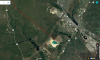
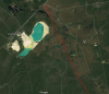
In my traveling around I stumbled upon an old diagonal road through Warren Grove. Following the road to either end, I was surprised it seemed to go all the way SE to near Staffordville before I lost it in the sand quarry. Following it in the other direction, it seemed to go all the way to the CNJ tracks between Woodmansie and Wheatland in the area of Pasadena. It is very faint in sections, and really only discernible from the slight difference in trees on either side. I have not physically walked any of this road, just followed it aerials.
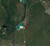
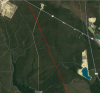
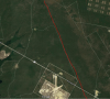
It's not very often you see older roads this straight, especially when crossing swamps and creeks. Attached are some rough views with a line drawn next to the road. Was this some type of township boundary? Or could it have been something else?
I spend a lot of my free time just following old roads on Satellite photos, then on foot, and then back again on satellite photos. I've learned a lot over the years, and it seems the landscape is always changing, and has been through the centuries for one reason or another.
In my traveling around I stumbled upon an old diagonal road through Warren Grove. Following the road to either end, I was surprised it seemed to go all the way SE to near Staffordville before I lost it in the sand quarry. Following it in the other direction, it seemed to go all the way to the CNJ tracks between Woodmansie and Wheatland in the area of Pasadena. It is very faint in sections, and really only discernible from the slight difference in trees on either side. I have not physically walked any of this road, just followed it aerials.
It's not very often you see older roads this straight, especially when crossing swamps and creeks. Attached are some rough views with a line drawn next to the road. Was this some type of township boundary? Or could it have been something else?

")