I left my house at 3:30 to go into Tabernacle and didn't notice any smoke. Traveling back south on 206 at 3:45 I saw a huge cloud of smoke. I continued to atsion where 206 was closed and emergency vehicles were arriving. With the wind and being so dry this could be bad.

Forest fire SW of Atsion Lake
- Thread starter ecampbell
- Start date
You are using an out of date browser. It may not display this or other websites correctly.
You should upgrade or use an alternative browser.
You should upgrade or use an alternative browser.
Just saw Action News at 5pm. Several hundred acres involved. 2 helicopters and 100 firefighters on scene. Backfires have been set to hopefully stop the main fire when it reaches them. The Forest Fire Service is using 206 as a break.
With this wind, I hope they can contain it soon. And to think, I had plans to go down to Atsion Ranger station on Sunday and maybe do a little hiking. Bummer.:cry:
With this wind, I hope they can contain it soon. And to think, I had plans to go down to Atsion Ranger station on Sunday and maybe do a little hiking. Bummer.:cry:
Any stones in that area Guy?Looks like this will open things up a bit.Just kiddin folks.I don't advocate burning the barrens down to find stones though I will take advantage of the openness to do so when opportunity arises")
Al
Al
In the grand scheme of things, isn't a forest fire a good thing for the pine barrens once in awhile???
On tv it looks like it is south of Chew Road.
If it is we may come up with a few more sawmills.
Guy
I was planning on going out that way on Sunday 10/26. Maybe even bring my 4 legged friend "Molly", our Golden Retriever, with me for a walk in the woods.
I guess that probably won't happen now.
I guess that probably won't happen now.
This one's a bit close for us boys & girls.
I saw the big bastard while coming home through Atco from work and called my wife. I thought, man this has got to be close. Going up the OWP it got meaner looking and as I went up Chew road it became apparent all of 206 was being diverted our way. The wind was a hard blowing and that weren't good. To add to the fun our power went out so on to the grill went dinner.
My yard is pretty open to that particular view and we just watched the plume evolve, grow, and blow. It would be super cool if it wasn't so darned close. Some pics from Pestletown...


While I took a few of the following, mostly I stood in Awe and a little fearful of this image. I watched it shift and grow and change in it's afterglow and realized just how animated these things can be.

I wish any who are in it's path to be safe and come through O.K.
g.
I saw the big bastard while coming home through Atco from work and called my wife. I thought, man this has got to be close. Going up the OWP it got meaner looking and as I went up Chew road it became apparent all of 206 was being diverted our way. The wind was a hard blowing and that weren't good. To add to the fun our power went out so on to the grill went dinner.
My yard is pretty open to that particular view and we just watched the plume evolve, grow, and blow. It would be super cool if it wasn't so darned close. Some pics from Pestletown...
While I took a few of the following, mostly I stood in Awe and a little fearful of this image. I watched it shift and grow and change in it's afterglow and realized just how animated these things can be.
I wish any who are in it's path to be safe and come through O.K.
g.
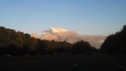
Wow, those are amazing photos. I have a few of my own, though not nearly so up-close and personal. Headed East over the Walt Whitman Bridge about 5:15 I saw the following and wondered what was going on. No reports of the fire on KYW Radio. This is probably something like 30 miles away - sorry for the bad photos, I was taking my life in my hands shooting with my iPhone and Canon Digital Elph at 70mph
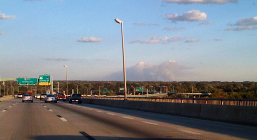
Headed East on the Atlantic City Expressway, this is what it looked like around exit 38. That plume had an eerie look in the setting sun, like a nuclear explosion:
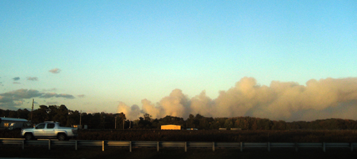
And this shot was somewhere around Hammonton on the ACE:
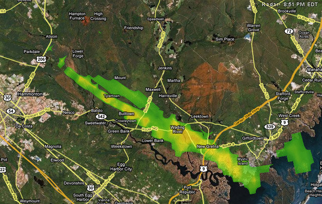
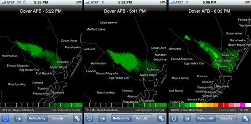
Finally, here's a composite of 3 different NEXRAD radar images showing the progress of the smoke plume as I drove East from Philadelphia. With the high winds, this must be a really nasty one. Hope everybody's safe.
Headed East on the Atlantic City Expressway, this is what it looked like around exit 38. That plume had an eerie look in the setting sun, like a nuclear explosion:
And this shot was somewhere around Hammonton on the ACE:
Finally, here's a composite of 3 different NEXRAD radar images showing the progress of the smoke plume as I drove East from Philadelphia. With the high winds, this must be a really nasty one. Hope everybody's safe.
Awesome pics Largo!! Just stay safe out there. Last time there was a fire out there, my fire dept. (Cinnaminson) got called in to help. Who knows what'll happen this time. Hopefully it'll be contained before we get called out.
Boyd - That next to last shot (Hammonton on the ACE), you can almost see the the smoke cloud moving!! You stay safe too.
Thanks for the pics guys!
Boyd - That next to last shot (Hammonton on the ACE), you can almost see the the smoke cloud moving!! You stay safe too.
Thanks for the pics guys!
I actually took a few dozen photos but it got a bit ridiculous. I really can't describe how just looking across the field the images I couldn't capture. The plume shifted and moved, brightened by the setting sun up top and changed below I assume in color to what material was burning. The wind twisted it and shaped it so many times it was staggering. The real deal though was watching the shifting shadows of those flames changing under the deck of that smoke mass. I tried to wrap my thoughts around a cloud that size and what manner of fire could reflect so clearly on it. Sobering.
g.
g.
While I love seeing the pines burn....I hope everyone who lives around there is ok. Doesn't Scott(redneck) live around there too?.......Hope you guys around Pesleton stay clear of it.
While I love seeing the pines burn....I hope everyone who lives around there is ok. Doesn't Scott(redneck) live around there too?.......Hope you guys around Pesleton stay clear of it.
Scott lives right behind me. (probably having a beer about now)
I was just about to edit my last post on the following...
This thing got hot and big! My wife just asked me to come look out front and the image is crazy! The sky glowing hard and waning like hot coals. I took a ride down the road and it is blocked off right where Chew(536) meets Pestletown. One can go no farther. I came home. My perspective because of my open lawn and a big field in front is much more visual than most with trees close up so this thing is kind of a close up show for me. I am not making fun, it's not a funny thing. It almost seems like it's crept more toward Hammonton past Dutchtown or towards Rockwood. Tough angle though so don't quote me on that one.
g.
I just checked the fire out on WUNDERMAP but it puts the fire location in or around a field across from the Hammonton airport. Just a bit off I would say.
NJ FOREST FIRE SERVICE
SITUATION REPORT
REPORT TIME AND DATE: 10/21/2008 1850 HRS
Reporting activity: Salders Ditch Fire #C102102
Originator: NJ Forest Fire Service
Incident Location: Both sides of Route 206 south ofAtsion Rec Area
SIT REP#1
OPERATIONAL SUMMARY: NJFFS fire towers discovered this fast moving fire at approx 1500 hrs. NJFFS ground and air resources are on location. Route 206 is being back fired and should be closed between Chew Road and Atsion Road. The fire has potential to grow to 1000 acres+. Burned ground from the August 2007 and low ground ahead of the fire may aid containment
SIT REP#2
OPERATIONAL SUMMARY: The fire has spotted across Route 206 in numerous locations. Due to smoke and darkness it is currently difficult estimate the extent of fire east of the highway. The east side of the highway was burned extensively in August 2007 so fire behavior is reduced in that area. The projected size is now 1400 acres not including the burned area east of the highway. Aircraft are grounded due to darkness. Air operations are scheduled to resume after sunrise. A temporary flight restriction is in place over the fire for a distance of five miles from the center and to a height of 3000 feet.
Four homes have been evacuated along Route 206. Route 206 in closed between Chew Rd and Stokes road. Atsion Road is also closed in the fire area.
A press conference is scheduled after 1900 at Cabin 8 in the Atsion Rec Area. The press in asked to report to the Indian Mills Fire Station, Willow Grove Road in Indian Mill. From there they will be escorted into the Atsion Rec Area.
Incident Commander: Mike Achey
OPERATIONAL DATA:
RESOURCES COMMITTED: 20 ENGINES, 2 HELICOPTERS, 4 DOZERS, 1 AIR TANKER. 100 FIRE FIGHTERS.
ADDITIONAL SUPPORT REQUIRED:
Law enforcement, traffic control, utility company support, structure protection