Hiking along Central Jersey line

M1 Abrams

Explorer
May 4, 2023
173
360
66
Burlington County
Note: In looking through some old threads, I found the disturbing story from 2009 about vandalized railroad trestles on the old Central Jersey line.

https://forums.njpinebarrens.com/threads/vandalized-trestle.5278/

Many of the people responsible for remedying that situation are still here -- thanks to you all.

It's probably just as well I didn't consider the possibility of a crazy person sabotaging trestles before doing my own series of hikes on, along, or in close proximity to the tracks from late February to April. They ranged from Chatsworth to where the tracks hit the fields near Rt. 30. You regulars here know the area through the tracks like the back of your hands, but for me it was all new territory. I hope to see many more corners of the Pine Barrens down the line, but this was a nice appetizer for me.


Atsion RR trestle over Mullica_2023_02_28.png

Atsion trestle over Mullica, February 2023.


Batsto River trestle_2023_03_09.png

Looking north over the Batsto to trestle, March 2023.


Relaxing on Batsto River trestle_2023_03_09.png

Relaxing on Batsto trestle, March 2023. (It's not a good picture, I know, but it was a sweet moment, just looking toward the setting sun, blessed to be here.)


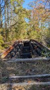
Sleeper Branch trestle_2023_03_12.png

Sleeper Branch trestle, March 2023.


Walkway out into bog_2023_03_12.png

Walkway out to water, west of Atsion along tracks, March 2023.


Albertson's Brook trestle_2023_03_16.png

Trestle over Albertson's Brook, March 2023.


E of Carranza along RR tracks_2023_04_03.png

East of Carranza along tracks, April 2023.


M1 Abrams accidental selfie 2023_03_09 .png

Well, if you were hoping for the best for last, it's not to be. I don't take many selfies, and this one was purely an accident. It happened the day of the Batsto trestle visit. There was some kind of notification, and when I pulled out my phone, I accidentally recorded this scary denizen of the Pine Barrens. You've seen enough of my pictures now to know I could never manage this intentionally. In future, I'll try to remember to always completely cover the lens with my fingers when I pull out the phone, just in case. :)
 

Shamongoloid

New Member
Mar 29, 2021
15
7
Shamong
Maybe it's just me but it looks intentional. It seemed weird that nothing else in the area is burned but the trestle, and it burned so bad it damaged the rails.

Maybe I'm just seeing ghosts where there are none.
 

enormiss

Explorer
Aug 18, 2015
607
409
Atco NJ
I’d say intentionally, and looks like it was pretty hot. I find the sawed out section after the fire interesting.
 

Teegate

Administrator
Site Administrator
Sep 17, 2002
25,938
8,678
Someone may have wanted the vehicle or pedestrian traffic to stop crossing it.
 

smoke_jumper

Piney
Mar 5, 2012
1,602
1,159
Atco, NJ
I was told last summer that someone burnt that trestle, although they told me that I was the Clark Branch. A couple months ago we made it out to confirm. The Clark branch is ok but we walked up on that as well. It’s definitely arson there was no forest fire there recently. Also it looks like some one started taking a chainsaw to it after it burnt as well. Fleming Pike was blocked by several trees for a couple years. Somebody also cleared the road all the way to the bridge.
5D51FEB6-ABD2-4E4D-A680-51E206F44097.jpeg
 
Last edited:
  • Like
Reactions: Boyd

Teegate

Administrator
Site Administrator
Sep 17, 2002
25,938
8,678
I wonder if anyone saw it? It might have burned itself out.
 

smoke_jumper

Piney
Mar 5, 2012
1,602
1,159
Atco, NJ
I wonder if anyone saw it? It might have burned itself out.
I heard about it back in the summer. I assumed it was known about by the time we went. I also figured that the reason the road going back to it was opened up possibly to get equipment back there to put it out. I’m not exactly sure when it burnt.
 

Teegate

Administrator
Site Administrator
Sep 17, 2002
25,938
8,678
No offense.... but you need to try and figure this out yourself. Go to the below link (after reading this carefully) and it will have the red pointer on the Jersey Central tracks. Slide the map each way and look for the word Sleeper and it will be on a stream that crosses the Jersey Central. Then at the top left of the page click on the word Topo and switch to 2015 and look where that stream crosses the Sleeper and you will actually see the trestle. Then find out what roads lead to it and try them. Just be careful if it has rained quite a bit or the roads may be flooded. If you want to explore the pines you need to learn this.


Teegate

Administrator
Site Administrator
Sep 17, 2002
25,938
8,678
Wh

Where is this tressle? I would like to go back and see the old abandoned tracks in atsion this weekend and I have never seen this

No offense.... but you need to try and figure this out yourself. Go to the below link (after reading this carefully) and it will have the red pointer on the Jersey Central tracks. Slide the map each way and look for the word "Sleeper" and it will be on a stream that crosses the Jersey Central. Then at the top left of the page click on the word Topo and switch to 2015 and look where that stream crosses the Sleeper and you will actually see the trestle. Then find out what roads lead to it and try them. Just be careful if it has rained quite a bit or the roads may be flooded. If you want to explore the pines you need to learn this.


Screenshot 2024-10-06 at 7.32.23 PM.png
 

SpinyPiney

Scout
Jan 15, 2013
71
76
Looks like the roads are sand, probably not possible by car but I'll have to see better if I get there
I was out there fishing a few weeks ago. I went in from 206 on Johnson Rd and that had a few deep sugary spots that I wouldn’t attempt without 4wd. The road that leads to the trestle when coming in from the south was in pretty bad shape at the turn to head toward Sandy Causeway Rd. I drive a Tacoma and got stuck in 2wd. Had to put it into 4wd to get around the corner there. And Sandy Causeway was pretty torn up and sugary at the Burnt Mill tee. All the usually giant puddles were bone dry at least. That small pond on the Clark Branch at Johnson rd was completely empty with tall grass growing in it and Goshen Pond was the lowest I’ve ever seen it. Actually walked around the beaver dam in what is normally water to the opposite bank.
 
  • Like
Reactions: Boyd and Teegate

RednekF350

Piney
Feb 20, 2004
5,050
3,320
Pestletown, N.J.
I visit that trestle area pretty often. Hard to believe some J%rkoff thought it would be cool to set it on fire.
My son shot his first Wood Duck there with a single shot 20 gauge 50 yards downstream from the trestle. My son hunkered down in the wet meadow grass and pass shot the duck. Not bad for a 10 year-old. :)
That was 29 years ago. Time surely flies.
 

SpinyPiney

Scout
Jan 15, 2013
71
76
Someone may have wanted the vehicle or pedestrian traffic to stop crossing it.
Wouldn’t surprise me if someone did it to keep the dirt bikes from crossing there. The bikers had covered the trestle with boards to cover some gaps and it looked like someone else had ripped them all up and then it was re-covered again. Like they were going back and forth. Someone had also cleared some trails heading east along the sleeper with a hedge trimmer or something at some point.
 
  • Wow
Reactions: Boyd

Teegate

Administrator
Site Administrator
Sep 17, 2002
25,938
8,678
I walked on it and it appears solid. You can still get across but some may consider it unsafe. Jessica does.
 
Top