manmade field in Wharton and an area cleared many years ago

mudboy dave

Explorer
Oct 15, 2008
950
19
42
atco
opentrailsnj.org
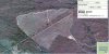
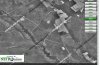
On the western portion of Wharton there are two manmade feilds that I was curious why they were cleared. I love going back to them and looking at the stars. heres the locations

http://maps.google.com/maps/ms?ie=U...d=111901079104381183408.000493ff56b070010f044

a little backlground on the big clearing that I camn remember

if you look at a 95 overhead you can see where it was pretty clear. I can recall riding my bicycle out there and there was a ginormous pile of woodchips out there. they only left a few random trees out there. If you ride by now you can tell the growth is different. It is alot thicker than the surrounding woods.
 

Teegate

Administrator
Site Administrator
Sep 17, 2002
25,627
8,228
The state at least in the past routinely allowed logging of certain area's of woods. That must have been one of them.

Guy
 

RednekF350

Piney
Feb 20, 2004
4,952
3,103
Pestletown, N.J.
Dave,
That clear cut was done around 1990. We used to take my kids and the neighbor's kids spotting back there in my '87 F-350.
The few trees that were left standing are known as seed trees.
When clear cutting with no plans to manually replant using seedlings, one leaves the most superior trees in the plot for natural seed production and distribution.
The trees that were left were the tallest and straightest in the plot. As you can see, the regeneration was rapid and dense.
A similar area was done at the same time off of 206 directly across from Dutchtown.
I am attaching a NJPB mapping where you can see the seed tree layout in the Dutchtown cut. If you look at your field in 1995 you will see the seed trees as well.
Scott
 

Attachments

  • Parkclear.jpg
    Parkclear.jpg
    155.5 KB · Views: 230

mudboy dave

Explorer
Oct 15, 2008
950
19
42
atco
opentrailsnj.org
Ohhh. I forgot about that one. i vaguely remember that as well from riding around with my dad. remember in 1990 I was only 8 year old lol. Any clue on the other 2 smaller clearings which haven't grown back?
 

Teegate

Administrator
Site Administrator
Sep 17, 2002
25,627
8,228
Ohhh. I forgot about that one. i vaguely remember that as well from riding around with my dad. remember in 1990 I was only 8 year old lol. Any clue on the other 2 smaller clearings which haven't grown back?

That could be a rye field for deer???

Guy
 

Teegate

Administrator
Site Administrator
Sep 17, 2002
25,627
8,228
Don't know.

Also, when the state surveyed Wharton they made quite a few mistakes, and even missed tracts of land what they thought was theirs. So it could be private property. You can see one of their errors in the attached map. Notice they penciled in a piece of property they missed.

Guy
 

RednekF350

Piney
Feb 20, 2004
4,952
3,103
Pestletown, N.J.
State does that?

The State USED to do that.
The small rectangles are rye fields planted by the State to encourage a healthy deer herd and to provide hunters with enhanced opportunities.

The fields in the photos were built in the 60's and I hunted around them and the Bulltown rye strips with my father beginning around 1969.
The program was abandoned in the 70's or 80's from what I can remember.
The Bulltown area has tremndously long strips planted along side of the roads traversing the woods.

I was actually pulled out of my truck by LE with my son in a car seat in 1987 near the one in your photo. They were in the process of busting a pot growing operation near one of the fields and thought I was involved. Wrong place at the wrong time but they cooled off quickly.

The attached 1963 aerial from Historic Aerials shows your fields bright and shiny.
 

Attachments

  • rye63.jpg
    rye63.jpg
    85.4 KB · Views: 248

Teegate

Administrator
Site Administrator
Sep 17, 2002
25,627
8,228
I forgot the attachment.
 

Attachments

  • private.jpg
    private.jpg
    41.1 KB · Views: 250

mudboy dave

Explorer
Oct 15, 2008
950
19
42
atco
opentrailsnj.org
Ohhh. Cool. Was always curious. I asked my dad but he couldn't remember. As soon as i mentioned this to him he instantly remembered. Guuy, what map is that that you posted the penciled in part?
 

Teegate

Administrator
Site Administrator
Sep 17, 2002
25,627
8,228
Ohhh. Cool. Was always curious. I asked my dad but he couldn't remember. As soon as i mentioned this to him he instantly remembered. Guuy, what map is that that you posted the penciled in part?

One of various maps I acquired.

Guy
 

gipsie

Explorer
Sep 14, 2008
547
67
55
atlantic county
The State USED to do that.

The Bulltown area has tremendously long strips planted along side of the roads traversing the woods.

Is Piney Pond Feedstrip one of those? I love that area and always wondered why they were called feedstrips (there are about three of them back around there if I remember correctly). I always assume that the roads in Wharton were named a long time ago.
 

MuckSavage

Explorer
Apr 1, 2005
598
218
56
Turnersville
Dave brought it up & Scott verified it. In the late 80's, early 90's, i worked for Stella Contracting. We had the contract to clearcut the trees outlined in Dave's post. I don't know why we did it, I simply showed up at 5 am, cut the marked trees & went home at 5 pm.
 

RednekF350

Piney
Feb 20, 2004
4,952
3,103
Pestletown, N.J.
Is Piney Pond Feedstrip one of those? I love that area and always wondered why they were called feedstrips (there are about three of them back around there if I remember correctly). I always assume that the roads in Wharton were named a long time ago.

Yes Gipsie and the nearby Eleanor Adams and Tylertown feedstrips.
Until you posted this, I never knew them by any other name than the Bulltown rye strips.
I never noticed that the names appear on the Google mappings.
The Tylertown strips shown at the bottom of the attached is where I spent a lot of time hunting with my dad in the 60's and 70's.
 

Attachments

  • feed.jpg
    feed.jpg
    65.3 KB · Views: 254
Top