Growing up in mizpah just about everybody worked at mizpah coat or the pixy toy company across the street. The coat factory made ladies clothing during the years i was growing up. Before that they made military clothing during the ww2. My father met my mother while visiting the factory in the early forties. His father was a tailer and had a shop in philadelphia. Tuhey were married in1945, and i came along in1946.

Mizpah Sand Quarry
- Thread starter Kevinhooa
- Start date
You are using an out of date browser. It may not display this or other websites correctly.
You should upgrade or use an alternative browser.
You should upgrade or use an alternative browser.

Buena Vista Ave is modern day Harding Hwy/US Route 40. I didn't realize the road kept the name into Hamilton Township. Does anyone know if the entire stretch of US40 between Mays Landing and Buena was called Buena Vista Ave? It was my understanding that roadway didn't extend that far before it was rebuilt as US40 in the 1920s.BKNJ
Bucky, Route 40 was laid out at 3-rods wide between Downstown and May Landing in 1817 (Gloucester County Book B, Page 207). The old Egg Harbour/Cohansey trail was its predecessor. The name Buena Vista Avenue was used on the 1870 Landisville survey, a proposed county seat for a new county to be named after Vineland's founder. It is my understanding that Buena Vista Avenue was unimproved until 1908. That year Richland General Store opened and the center of the village commerce began to move away from the West Jersey Railroad and to the newly graveled road. Before that Buena Vista Avenue was impassible in winter thaw and in rainy seasons. Richland farmers with horse teams were called out to rescue mired wagons and on occasion a newfangled automobile.
Various ethnic settlements between Buena and Mays Landing were laid out as railroad enterprises so Buena Vista Avenue was of secondary importance but listed on survey maps. Those settlements, respectively, included: New Rome (Sicilian), Richland (Welsh, originally Deerton), Ruskville (Jewish), Mizpah (Jewish), and Edwina (Jewish). The "Buena Vista" referred to the tavern (name changes something like Campbell's to Veal's to Hamilton's to Campbell's to Buena Vista to Midway Inn).
When purchased by Cake in 1848, the tavern was renamed the Buena Vista after the 1847 Mexican War battle victory. Outnumbered, we whopped the Spanish, and refused to honor it with a Spanish pronunciation. Both the tavern and the hamlet were known as Buena Vista, and was the political center of the area. This curious pronunciation (Byoó·na) is the same with other Buena Vistas of the time (e.g., Cumberland County "Buena Vista" near Greenwich, NJ; VA; CO).
There is much confusion with Campbell's Tavern's past, and I suspect the original establishment may have actually begun at Archibald Campbell, Senior's eighteenth century cabin located about a half-mile east of the Midway at the intersection of the original Cohansey and Tuckahoe trail intersection (near today's Tuckahoe and Union Roads). That cabin is described in the October 12, 1907 edition of Valley Ventura:
Also read about the Buena Powder Charcoal Mill (October 05, 1907), built about the time of the 1817 road improvement. I suspect the post log cabin Campbell's tavern and its associated charcoal works are c.1817.
S-M
Cool, S-M. Grew up on a property in BVT that stretched between Buena Vista Ave and the WJSS railroad. Always was curious just when US 40 was appropriated officially, as there where some deed notes concerning property being allocated in 1930.
Rereading some of this thread, was the entire WJSS RR double tracked? My old neighbor remembers riding the WJSS and told me about it being electrified. However, he made it sound like it was single tracked... and the ROW seems too narrow for dual tracks.
BKNJ
Rereading some of this thread, was the entire WJSS RR double tracked? My old neighbor remembers riding the WJSS and told me about it being electrified. However, he made it sound like it was single tracked... and the ROW seems too narrow for dual tracks.
BKNJ
I am under the impression that the West Jersey & Atlantic Rail Road was all double-tracked. The ultimate Richland railroad sensory experience was when east- and westbound WJARR trains crossed the trestle at the same time that north- and southbound Cape May Branch trains passed beneath them. W. George Cook complied an 8-page log of South Jersey Railroads (4/4/1965–5/4/1965). According to his notes, the 34.46-mile-long WJARR between Newfield and Atlantic City was chartered 11/5/1875 & 11/5/1879. Construction occurred between 11/1879 and 6/1880, and was electrified between 9/18/1906 and late 1935. WJARR was operated by WJ(1853) from 6/16/1880 to 9/1/1885; WJ(1885) from 9/1/1885 to 12/31/1887; WJ(1887) from 12/31/1887 to 5/4/1896; then merged into WJ&S on 5/4/1896. The line was abandoned in 1952. I'll ask Jerseyman if Cook's notes are published, as there is a lot of information in them.
S-M
S-M
Attached is the track diagram of the WJS Newfield Branch - ACRR Cape May Branch at Richland as sketched by former railroad employee Eddie Fell. Looks like double track over double track. Although built around the 1870's-1880's, I think I remember reading the electrification on the Newfield Branch being completed sometime around 1906 and the Cape May branch being double tracked around the time the PRR lease to use that trackage to get from Winslow Jct. to Woodbine Jct. to bypass the bottle neck in Millville being around the turn of the century as well. I have notes somewhere if someone needs specific dates. A book I have on the history of the PRR stated that the electrification was one of 2 test projects for the Hudson Tunnels from Jersey City to NYC.
Attachments
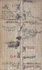
Attached is the track diagram of the WJS Newfield Branch - ACRR Cape May Branch at Richland as sketched by former railroad employee Eddie Fell.
Cool. I'd love to hear more about the "frog war" that occurred where the two lines crossed, only one of three in the State that I know of. The legend is that when the Philadelphia & Seashore Railway line was first run in 1890 (today's Cape May Branch), its operators were planning to sneak in a crossing switch or "frog"at its WJARR intersection atop a gravel hill.
PSR hired Richland's Welsh settlers to quickly construct the crossing, but were thwarted by WJARR Irish thugs in a brawl that my townsfolk soundly lost. To add insult to injury, the Welsh had left their Wilkes-Barre mining jobs to settle Richland as colliers in escape of Irish gangs (Molly Maguires) that forcefully took over Pennsylvania's mines a decade-or-two earlier. For the next three years Richland-based workers toiled to hand-dig a cut into the dense hard-packed subsoil (fragipan) to pass beneath the WJARR. In the interim, a Winslow & Richland Railroad and a Richland & Petersburg Railroad each ended in loops at the frog war site. Wagon-loads of charcoal were shoveled into rail cars at the loops for transport to market.
X213 marks my property. I never knew that the Cape May Branch had two platforms, which explains the need for two adjacent railroad-owned lots along US Route 40 (old 48). The "water plugs" are at the whistle-stop "Landis Avenue" platform that was used by woodland farms like the one I grew up on (before my time). The concrete platform and water-tank frames are still there. I pulled a lot of "pike" (pickerel) out of that South River hole using rooster tails, and hook-and-wormed the darkest, meanest, and gruntiest "pouts" (catfish) you ever saw by the dozens.
S-M
Last edited:
So, roughly how wide would the WJSS cinder pile need to be to be double tracked? I'm assuming its 4' 8.5" gauge. I might need to go back there sometime soon and poke around.
Looking at Eddie Fells diagram, it occurs to me that it never occurred to me that Main St. crosses the tracks in two places, which is kind of odd. Richland is kind of odd, though. ;-)
BKNJ
Looking at Eddie Fells diagram, it occurs to me that it never occurred to me that Main St. crosses the tracks in two places, which is kind of odd. Richland is kind of odd, though. ;-)
BKNJ
Here are three early Richland plot plans showing railroads.

S-M
Plan of Richland, Railroad Centre for Cumberland Colony Enterprise, Atlantic Co., N.J. Surveyed by Fowler & Lummis, Civil Engineers, Philada, PA, 1884.

Map of the Town of Richland, New Jersey, F. Bourquin, 31 S. 6th St, Philad'a, undated (c.1890).

MAP NO.1, Building Lots, Richland, NJ, Charles W. Jones, Owner, 1899.
Map of the Town of Richland, New Jersey, F. Bourquin, 31 S. 6th St, Philad'a, undated (c.1890).
MAP NO.1, Building Lots, Richland, NJ, Charles W. Jones, Owner, 1899.
S-M
Very interesting. Very optimistic plans... but I suppose that how all these land company towns were.
The siding is also interesting... it explains why RR Blvd and West Jersey Blvd widen out around it. Is there anything left of this station?
Looking at all those tiny, tiny little plots of land, it reminds me of a question I posed (and never got an answer to)... since it takes tens, if not hundreds of these little lots in Richland, EHC or Gigantic City to make a buildable lot... and since some people don't seem to be bothered to consolidate the little lots into big lot, do people end up paying a hundred little tiny property tax bills? LOL!
Are there more of these map sections?
BKNJ
Richland is kind of odd, though. ;-) BKNJ
OK,
Now I have no choice but to agree with you! My daughter is enrolled as a graduate student at Stockton University, and was conducting research into Richland Village dynamics. She noted that our property is listed on Google Maps as a culinary destination, identified as "dead body found."

Maybe zombie-land fare? Mmm, brains, sweet brains....
S-M

Hi I'm local to the area was the mizpah toy company located on Rt. 40?Growing up in mizpah just about everybody worked at mizpah coat or the pixy toy company across the street. The coat factory made ladies clothing during the years i was growing up. Before that they made military clothing during the ww2. My father met my mother while visiting the factory in the early forties. His father was a tailer and had a shop in philadelphia. Tuhey were married in1945, and i came along in1946.
And if so where?
I do historical map research as a hobby
Thanks!!
As I understand from Mizpah historian Virginia Gale (and former postmaster), the toy factory was at the end of DeHirsch between Railroad Boulevard and the tracks (now open park land).
Yes I see now I did look at some old maps that led me to the area of the parkAs I understand from Mizpah historian Virginia Gale (and former postmaster), the toy factory was at the end of DeHirsch between Railroad Boulevard and the tracks (now open park land).
Thanks that means a lot!!