I went downstream on the Wading today beginning on route 563 at Burnt Bridge. I went a little more than halfway to the reservoir, and then came back (that was by design, I was looking for a plant).
Anyway, it's kind of a mess back there in most spots. I hit 4 beaver dams, all a big pain to cross in a kayak. Even though the water is low because of the drought, the beaver have really kind of ruined the experience of being on the river. If I had my way I'd eradicate all of them, or at least ship them to a state that welcomes them. There is a lot of rice cut grass in the savannas now...I'm not saying their habits cause this, maybe it was due to the cranberry bogs. But the river has really changed, and not in a good way.
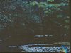
There were some good spots, usually the cleared area just before a beaver dam.


One of the dams

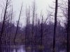
Choked up. There is one area where the river seems to disappear into a sea of rush. Very hard going. Luckily I could pull through by grabbing the rushes.

A streamside savanna choked up with cut rice grass. Ed Campbell, you have experience with this river in the 1970's. What do you think?

Anyway, it's kind of a mess back there in most spots. I hit 4 beaver dams, all a big pain to cross in a kayak. Even though the water is low because of the drought, the beaver have really kind of ruined the experience of being on the river. If I had my way I'd eradicate all of them, or at least ship them to a state that welcomes them. There is a lot of rice cut grass in the savannas now...I'm not saying their habits cause this, maybe it was due to the cranberry bogs. But the river has really changed, and not in a good way.
There were some good spots, usually the cleared area just before a beaver dam.
One of the dams
Choked up. There is one area where the river seems to disappear into a sea of rush. Very hard going. Luckily I could pull through by grabbing the rushes.
A streamside savanna choked up with cut rice grass. Ed Campbell, you have experience with this river in the 1970's. What do you think?