One Source of the Mullica

bobpbx

Piney
Staff member
Oct 25, 2002
14,637
4,813
Pines; Bamber area
Yesterday was a good day to be outside. Temperature and sunshine perfect. I decided to go to "one" of the sources of the Mullica, just west of route 73 in Berlin. See Purple line below. The original source here may have been just on the other side of the tracks, but that has been lost to the RR and development.

1731262328337.png

Here it begins, at this stand of Phragmities.
1731262404048.jpeg

Further down, it assembles itself into a narrow canal, likely man-made to drain. You can just see the sharp left turn ahead.
1731262505506.jpeg

After the left turn, it broadens out into a stream, but likely intermittent. Of course today, just dry.
1731262618392.jpeg
 

bobpbx

Piney
Staff member
Oct 25, 2002
14,637
4,813
Pines; Bamber area
Not far down, she flows under 73 here (that is, she flows when wet).
1731262713367.jpeg

A highlight of this grand day is seeing this rare convertable Falcon Sprint near the canal.
1731262813664.png

From Wiki. But I like it.
For the 1964 year, Ford added a Sprint Package, which gave the Falcon the Fairlane's 260 V8, a stiffer suspension, and a louder exhaust. Because the Mustang had the same options that the Sprint had for only a small amount more, the Sprint never caught on. Even with the addition of the 289 V8 in late 1964, the Sprint was overshadowed by the Mustang, and was discontinued after 1965.
 

bobpbx

Piney
Staff member
Oct 25, 2002
14,637
4,813
Pines; Bamber area
It is interesting to note (I may have brought this up before), that the National Hydrography dataset makes it clear that the water is designated as flowing both ways: 1) to the Rancocas via Haynes Creek running to Medford Lakes, and 2) to the Alquatka Branch and thense to the Mullica. But if you view the aerials in that area, someone dug a canal to pull some water towards the cranberry bogs.

1731266340358.png


Or is it a canal?
1731266656867.png
 

martink

Scout
Apr 5, 2009
34
39
57
Hammonton NJ
www.quakerranter.org
Nice write up. I pass that area frequently but haven’t explored. It always bothers me going south on 73 when I pass the sign telling motorists they are entering the Great Egg Harbor River watershed. I always yell out “This is the Mullica!”
 

Attachments

  • IMG_0711.jpeg
    IMG_0711.jpeg
    1.1 MB · Views: 11
  • Love
  • Like
Reactions: Boyd and bobpbx

bobpbx

Piney
Staff member
Oct 25, 2002
14,637
4,813
Pines; Bamber area
Nice write up. I pass that area frequently but haven’t explored. It always bothers me going south on 73 when I pass the sign telling motorists they are entering the Great Egg Harbor River watershed. I always yell out “This is the Mullica!”
I thought it was interesting, whilst poking around, to note that if you just branched out a bit from the X, and went in a huge 4 mile diameter circle, you'd hit the Big Timber, Cooper, Great Egg Harbor, Rancocas, and Mullica.

1731277154123.png
 

bobpbx

Piney
Staff member
Oct 25, 2002
14,637
4,813
Pines; Bamber area
One more thing from yestereday that is quite interesting. If you'd like to be an assassin, this plant growing on the roadside in Berlin will help you set it up.

1731278266711.jpeg
 

Spung-Man

Explorer
Jan 5, 2009
999
728
64
Richland, NJ
www.researchgate.net
It is interesting to note (I may have brought this up before), that the National Hydrography dataset makes it clear that the water is designated as flowing both ways: 1) to the Rancocas via Haynes Creek running to Medford Lakes, and 2) to the Alquatka Branch and thense to the Mullica.
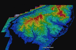
Note how the Mullica and southern Rancocas valleys align, cutting a gap through hard cuesta, a chain of hills that are steeply sloped on one side and gently sloped on the other that reside just to the east of the New Jersey Turnpike. It may be that a long time ago the Mullica and the Rancocas were one and the same—an ancient Delaware perhaps?

Such a drainageway neatly divides the Pine Barrens into a northern/southern half. It also neatly divides the cuesta area into the North Central/South Central Uplands.

Screenshot 2024-11-10 at 10.08.41 PM.png

That cuesta kept Delaware River glacial outwash from entering the Pine Barrens. Starved of such sediments the Pine Barrens developed into a badlands landscape (Demitroff 2016: 125). This perhaps makes the Pine Barrens unique as an antisyngenetic ice-marginal coastal plain.

S-M
 

RednekF350

Piney
Feb 20, 2004
5,050
3,320
Pestletown, N.J.
I had to review a site plan for Berlin Township in the late spring this year for a change in use of an existing industrial building. The building is located at the headwater area up against the railroad. There was water in the river back then, but any flow was imperceptible.
Here is the spot I photographed.

The industrial park was built in 1975 before State stormwater rules and the Pinelands Comprehensive Management Plan existed. There is no stormwater pre-treatment providing filtration and no infiltration basins as are required today. A simple swale on this property conveys runoff from the site directly to the headwater area. The swale can be seen in the LIDAR.

Although there was water in the stream at the time of my inspection, it is hard to see in these June 2024 photos.

IMG_6284 (Small).JPG
IMG_6286 (Small).JPG
 
Last edited:

bobpbx

Piney
Staff member
Oct 25, 2002
14,637
4,813
Pines; Bamber area
I had to review a site plan for Berlin Township in the late spring this year for a change in use of an existing industrial building. The building is located at the headwater area up against the railroad. There was water in the river back then, but any flow was imperceptible.
Here is the spot I photographed.

The industrial park was built in 1975 before State stormwater rules and the Pinelands Comprehensive Management Plan existed. There is no stormwater pre-treatment providing filtration and no infiltration basins as are required today. A simple swale on this property conveys runoff from the site directly to the headwater area. The swale can be seen in the LIDAR.

Although there was water in the stream at the time of my inspection, it is hard to see in these June 2024 photos.

View attachment 23799View attachment 23800
Bingo Scott, I found the outlet to that into the Mullica canal I showed in my photo. Here below is the outlet from the Industrial park into the wider canal. It is strewn with a few big plastic pots, most likely from cannabis cultivation many years ago. A well hidden area on the opposite side of the industrial fenceline.
1731331967004.png
 

RednekF350

Piney
Feb 20, 2004
5,050
3,320
Pestletown, N.J.
Bingo Scott, I found the outlet to that into the Mullica canal I showed in my photo. Here below is the outlet from the Industrial park into the wider canal. It is strewn with a few big plastic pots, most likely from cannabis cultivation many years ago. A well hidden area on the opposite side of the industrial fenceline.
View attachment 23801
Take a look at aerials back into the 1940's Bob. Until 1995, the southerly corner of the vacant property containing the headwaters stayed relatively undisturbed and wooded. We were the Berlin Township engineers in 1995 and my foggy recollection is that a prior owner, who was a fairly prominent businessman in Berlin Borough, cleared and regraded the entire property around that time period without any approvals. I also vaguely recall that he eventually received a site plan approval to develop most of the property. Nothing ever happened. The entire parcel is now Township-owned.
 

bobpbx

Piney
Staff member
Oct 25, 2002
14,637
4,813
Pines; Bamber area
Take a look at aerials back into the 1940's Bob. Until 1995, the southerly corner of the vacant property containing the headwaters stayed relatively undisturbed and wooded. We were the Berlin Township engineers in 1995 and my foggy recollection is that a prior owner, who was a fairly prominent businessman in Berlin Borough, cleared and regraded the entire property around that time period without any approvals. I also vaguely recall that he eventually received a site plan approval to develop most of the property. Nothing ever happened. The entire parcel is now Township-owned.
Yeah, seems like somebody simply said "what's done is done".
 
Top