Oregon 300 on sale at REI for $250

Boyd

Administrator
Staff member
Site Administrator
Jul 31, 2004
9,537
2,792
Ben's Branch, Stephen Creek
If you're looking for a GPS, this strikes me as a good deal. The $250 price is listed in REI's Winter Sale brochure and is in effect from November 20-30. Here's a link; I guess it will continue to show the $400 price until the sale begins: http://www.rei.com/product/775802

This unit will give you full compatibility with the new raster-based maps of the Pines which I have been uploading to GPSFileDepot - such as:

http://www.gpsfiledepot.com/maps/view/241/

http://www.gpsfiledepot.com/maps/view/240/

http://www.gpsfiledepot.com/maps/view/246/

http://www.gpsfiledepot.com/maps/view/242/

Garmin's new custom map format makes it easy to use real USGS 24k topo's and NJ 2007 orthoimagery, like the examples below.
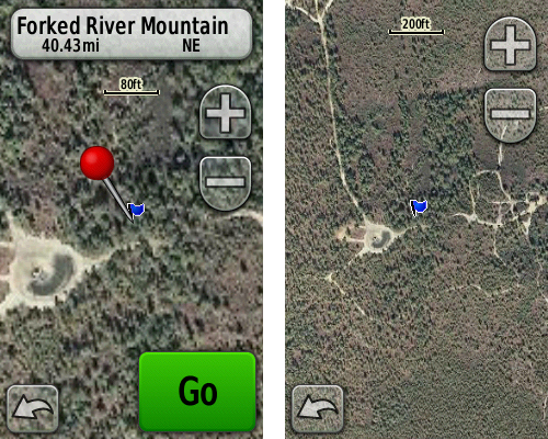
wharton03.jpg


frm02.jpg


More will follow - as time permits. :)
 

Teegate

Administrator
Site Administrator
Sep 17, 2002
25,628
8,229
Looks like a good deal Boyd. I have always wanted aerial and real topo maps in my GPS.


Guy
 

Boyd

Administrator
Staff member
Site Administrator
Jul 31, 2004
9,537
2,792
Ben's Branch, Stephen Creek
Yes, it has taken awhile for the prices to drop. However the Oregon 200 is $223 at Amazon, in case you miss the sale. The 300 adds a compass and altimeter, plus about 1GB of internal memory. The 200 has none of these, but personally I don't think that's a big issue. Memory is pretty much a moot point since micro SD cards are cheap.

The compass is like the 60csx compass and must be held flat to work. It also drains your batteries more quickly. I rarely use it myself. The top of the line Oregon (550) has the new triaxial compass which works in any position, and so does the new Dakota 20.

The Dakota 10 is $272 at Amazon and has a smaller screen with no compass or altimeter. So I think this Oregon 300 deal at REI is pretty decent. Analysts are expecting heavy competition for consumer dollars this holiday season, and lots of electronic gadgets to choose from. Maybe we will see more nice sales?

BTW, Garmin has moved the "custom maps" feature out of beta and it is included with the latest software update for the Oregon, Dakota and Colorado. Just connect your gps to your computer and run Webupdater. You will then be able to download and use my new maps.
 

Teegate

Administrator
Site Administrator
Sep 17, 2002
25,628
8,229
I actually may go for the 300. I am so tired of not having aerial or real topo maps.

Guy
 

Boyd

Administrator
Staff member
Site Administrator
Jul 31, 2004
9,537
2,792
Ben's Branch, Stephen Creek
Cool. The 60csx is still quite popular, so it probably has a decent resale value.

I know there are a few members here already with Oregons and Colorado's, so I have added information about my new maps to the "sticky" about my Map of the Pines. See this thread for a list of what's available, and let me know which areas you'd like me to work on next: http://forums.njpinebarrens.com/showthread.php?p=73342#post73342
 

Boyd

Administrator
Staff member
Site Administrator
Jul 31, 2004
9,537
2,792
Ben's Branch, Stephen Creek
I have the 400t, but assume they are the same. I have never really measured battery life and rarely use the Oregon for more than a few hours at a time. It is very dependent on backlight setting of course. On a bright sunny day, if you tip the screen correctly to reflect the light, you can run with no backlight. Most other conditions require the backlight.

I have only used the el-cheapo big packs of batteries from places like Home Depot, such as Rayovac. Just guessing - with lots of backlight use I might only get 4 or 5 hours with these batteries.

But look at some of the posts in the Groundspeak GPS forum. I have seen multiple posts where people say they get as much as 20 hours using the high quality rechargeables. Here's some more info: http://garminoregon.wikispaces.com/Power
 

Mts83

Explorer
Oct 24, 2008
207
1
Sourland Mountains
www.wtfda.info
This is tempting... and 250 is so much easier to swallow than the usual ~400. My old legend C, while adequate, isn't powerful enough to handle the newest datasets by a longshot. And is quite slow.

As far as I know, the only difference between the 300 and 400 are internally stored maps. The "T" being for topo... everything else is identical.
 

Boyd

Administrator
Staff member
Site Administrator
Jul 31, 2004
9,537
2,792
Ben's Branch, Stephen Creek
My first handheld GPS was a Magellan Meridian Gold, then I upgraded to a Legend C when it first came out, and thought the color screen was SO cool. :) But by today's standards, it's showing its age. Mine would stuggle to get a signal under heavy tree canopy and lose satellite lock frequently. The 24MB of internal memory is really limiting today, especially with more detailed mapping becoming available.

The guts of the Oregon 300 and 400t are basically identical, EXCEPT the 400t has 4GB of internal memory while the 300 has 1GB. They both have the same amount of free memory (~1GB), with US Topo taking up the other 3GB on the 400t.

That leads to another subtle difference with Garmin's legacy map format. They needed to tweak US Topo to fit the whole US into the unit. It's not a file size issue, but an issue of how many map segments (individual tiles) the format permits. On the older Garmin units, this maxes out at 2025 segments. The DVD version of US topo contains about 6,600 segments, so you can only load 1/3 of the US on these older units.

They upped the segment limit on the Oregon series to about 4000, but this still isn't enough load all of US Topo into an Oregon 300. The version of US Topo on the 400t uses much larger segments, so only about 400 are required for the entire US. This gives you lots of freedom to add more maps (the 4,000 segment limit on the Oregon applies to the total segments in ALL maps you have installed).

Garmin does not sell this 400 segment version of US topo as a standalone product. The reason for having 6,600 segments in the DVD version is probably to provide compatibility with their older units (like your Legend C) which don't have much memory.
 

Mts83

Explorer
Oct 24, 2008
207
1
Sourland Mountains
www.wtfda.info
Thanks for the correction Boyd, I didn't realize the difference in storage space. Though it makes sense. 1 Gig will still store a decent amount of data at least, then combined with a card you could have coverage comparable to what the 400t offers (using freely available topo data). The 24MB on the C is limiting, it makes me wish I had waited for its successor to come out which did have a memory slot- . It would have given me a little more flexibility. Oh well :)

I have to make a comment about its receive too. A friend of mine owns a 400t; so many times he holds a lock, especially in a rocky/canyon area, or deep tree cover while my Legend C just continually shows "acquiring satellites". He managed to grab the 400 for a similar deal REI ran, a few months back.

Interesting about those tile differences/limits too, thanks.
 

Boyd

Administrator
Staff member
Site Administrator
Jul 31, 2004
9,537
2,792
Ben's Branch, Stephen Creek
1 Gig will still store a decent amount of data at least, then combined with a card you could have coverage comparable to what the 400t offers (using freely available topo data).

Well... yes and no. :) I agree that the 1GB internal memory on the Oregon 300 is not a problem at all. Put a 4 or 8GB card in the slot and you will have all the room you'll ever need. Garmin map files cannot be any larger than 4gb. If you're on a tight budget, the 1GB of free memory on the Oregon 300 should be enough to get you started - my most detailed Map of the Pines is only 200MB. These new "custom maps" I've been making range from about 20MB to 35MB, so they don't take up a whole lot of space either.

But having "coverage comparable to what the 400t offers"... that might be hard to do. Again, it doesn't have to do with the amount of memory, but the total number of map segments. All of your combined maps can't have more than 4,000 segments on the Oregon.

But honestly, this is pretty much a non-issue. Does anybody really need maps of the whole US available on their GPS every day? It's a nice little bonus on the 400t, but hardly a necessity.
 

Boyd

Administrator
Staff member
Site Administrator
Jul 31, 2004
9,537
2,792
Ben's Branch, Stephen Creek
The PN-40 is currently on sale for $200 at Amazon: http://www.amazon.com/exec/obidos/ASIN/B001FVLTNA/timflight-20 . It's $400 (with a $50 rebate = $350) at REI, but I'm not clear on what is included with each so read all the fine print and caveat emptor! http://www.rei.com/product/777824

I'm told the amazon deal won't last long, it may end today. The site says 26 in stock right now. Of course you will probably want the map subscription with the PN-40, and I believe that's extra.
 

Boyd

Administrator
Staff member
Site Administrator
Jul 31, 2004
9,537
2,792
Ben's Branch, Stephen Creek
$350 isn't a bad deal for the 400t, if you feel you need the Garmin 100k topo's for the full US at all times. Otherwise, I would go for the 300 at $250. You can buy the 100k topo's on disk for under $100, and you can also use them on your computer. The pre-loaded topo's on the 400t can't be used in mapsource on your computer.

Bummer that the 300 is on backorder... but not too surprising since that's great deal.
 

Boyd

Administrator
Staff member
Site Administrator
Jul 31, 2004
9,537
2,792
Ben's Branch, Stephen Creek
Top