All,
Today was a day to revisit a few places we were at before and to find a few monuments and a stone we did not find in previous jaunts. Our first visit to this area was in 2009 and today I noticed a few things of interest that was not there before.
We parked at the stone hills on Carranza road and walked over the hill heading west all the way to the Jersey-Maine gun club off of Oriental Road. While heading down the hill on the other side we came up a wooden fence the state has erected to stop what I believe is the Wilkinson Deer Club from accessing state land from their property with a vehicle. Notice in the below photo the club in the background and the fence which appears to have been driven around at one time in the past. And new posts have been erected to stop someone from going around them. Someone put a trash bag on the post so that it can be easily viewed.

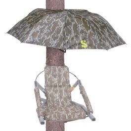
A little surprised to see that the state went to the trouble of doing this. We continued through the woods traveling on state land until we reached the cedar swamp near the Jersey-Maine club. As we neared the cedar swamp we found this interesting tree stand unlike any I have viewed before. They had placed an umbrella above the stand cutting out a portion of it to fit around the tree. They then fastened the umbrella to the tree. I was impressed.
There also is a corduroy path they made to access the stand through the swamp. I also like this as it made our trip somewhat easier.
We finally made it to the edge of state land on the road to the club. I was looking for the monument marking the state corner and we came out of the woods right by the location. My GPS took me across the original road to a metal stake in the ground between the original road and a new road cut through the woods. This was different than the last time we were there years ago.


Looking the location over, and knowing the state property lines at that location crosses the road, there may have been some discussion to the fact that their vehicles were driving on state land or private land and had been for many many years. Keep in mind this photo which I will post again shows the monument on the other side of the original road from where I am taking the photo which proves their road was crossing state land. Then notice the new road in the distance which in the last approximately 7 years had to be plowed through to keep their vehicles from crossing a very small section of state land and maybe private land. To be honest, I only know it did cross state land and can't say if it crossed private land. I would love to know the reason they plowed it. If it was the state forcing them it seems overkill since it only crosses a small portion as you can see in the below photos.
Keep in mind, I am on state land and the property lines comes in from behind me and to the right, crosses the road to the white metal in the circle. It then turns and head down the road crossing back over the road to the left.
Jessica is on state land where I took the above photo from the original road, and the new road bypasses state land and merges where I am standing right on the state land right at the green arrow in the second photo just below this one.
The orange is the original road, the red is the new road and it circumvents the blue line past the state land.
On the way back we stopped at a Wharton corner we visited many years ago. It has a donkey rail hammered in the ground for the corner. There is another one nearby as well.
Donkey rail.
I take distance photos to make it easier to know where they are.

")