Sweeten Water Branch

manumuskin

Piney
Jul 20, 2003
8,555
2,469
59
millville nj
www.youtube.com
A few weeks ago me and a friend of mine were scouting a route down Manumuskin Creek for a future plant hike and we wandered through an area where Sweeten Water Branch and Manumuskin meet. http://maps.njpinebarrens.com/#lat=39.389710402974586&lng=-74.92446083229066&z=17&type=nj1930&gpx=
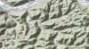
As you can see at this link there is a line of Red Cedar trees following the road.These are what we first noticed but nearly everyone has been cut down and only the stumps remain. There are a few live trees left and a few grape vines and right in the semi clearing visible at the marker there was a slight grassing of the area that looked like possibly a yard at one time.There were no signs of a foundation and no Spleenwort or any plants that would suggest lime in the ground. As you see the aerials all the way back to 31 show no buildings or clearings and the old topos show nothing either. We're looking for info since the hike will go right through this area.Do any of the resident historians on this site have any info on a settlement at the confluence of the Manumuskin and Sweeten Water branches? There is also nothing on the Hartman Maps. Any info will be much appreciated.
 

Spung-Man

Explorer
Jan 5, 2009
978
666
64
Richland, NJ
loki.stockton.edu
Manumuskin,

We have similar tastes! You picked a favorite location of mine, and one very dear to my heart.


I never heard anyone add “Branch” to that waterway, which behaves more like a cripple anyway. It was always just Sweeten Water, way back by third field (my hang-out). I’ve always considered your tagged part of the trail to be a continuation of Hesstown’s Cow-S--t Road, so named for the remarkably meadow-muffin-like stump holes along route. It was part of the route used to cross the Manumuskin to get to Parsons Towne, then on to the Oasis or Rattletrap. The location is a good candidate for a charcoal camp and/or naval store extraction site. Cripples were often preferred locus for tar kiln operations.


Margaret Louise Mints (1968: 11) in the The Great Wilderness writes of a log church where the famed missionary John Brainard preached to Indians near Vineland. She claimed that “The Place of the Stone” was a favorite Indian “meeting place,” which was not far from a small campsite known as “The Pond on the Hill” (i.e., a spung). Brainard’s Mission was said to have been built of redcedar (Juniperus virginiana) beams with a shingle roof. Growing up I heard similar lore from farm hands, hunter, firefighters, and woodcutters. Did you ever see the piers from the steam-powered sawmill to the southeast?

Yes, the Great Wilderness below the Mullica can be just as exciting as the Pinelands Core, perhaps better since so much remains enigmatic. In the 1930s Nature Boy of Java, a hermit, lived between Hesstown and Milmay (hint, hint – Osborne and Lindsay Villages).

S-M
 
  • Like
Reactions: Menantico and Boyd

manumuskin

Piney
Jul 20, 2003
8,555
2,469
59
millville nj
www.youtube.com
I know where the stone is He reportedly preached at and I"ve read the Great Wilderness.Only problem is I"ve also read Brainerds diary and he claims nowhere in the diary to have ever gotten anywhere near Manumuskin Creek.He was up at Crosswicks in Monmouth county but I can find no evidence other then Mints legend that he was down here..
Thanks for the idea about a charcoal camp.could be something to that since there are no foundations,just a few "people plants"
 

manumuskin

Piney
Jul 20, 2003
8,555
2,469
59
millville nj
www.youtube.com
I think I added branch on my own.To me any crik that small that is tributary to another is a branch.I think it's a WV term I probably picked up from my grand parents since both were born on Branches. Cripple would probably be more of a NJ term.. The topo just says as you said "Sweeten Water"
 

bobpbx

Piney
Staff member
Oct 25, 2002
14,212
4,313
Pines; Bamber area
I think I added branch on my own.To me any crik that small that is tributary to another is a branch.I think it's a WV term I probably picked up from my grand parents since both were born on Branches. Cripple would probably be more of a NJ term.. The topo just says as you said "Sweeten Water"

Branch is a common term for pine barren streams. I think Mark was just speaking of that stream.
 
  • Like
Reactions: manumuskin

bobpbx

Piney
Staff member
Oct 25, 2002
14,212
4,313
Pines; Bamber area
My Mom was born on Dry Branch and my Pop Pop on Long Branch. I guess I"m just a twig.

I didn't realize they wuz born and reared in the pines.

BRANCH2.PNG


braNCH.PNG
 

manumuskin

Piney
Jul 20, 2003
8,555
2,469
59
millville nj
www.youtube.com
Strip Mines.The area is full of em. It's funny you should pick Horse Creek. My Granny lived there as a small child and I went there for the first time about five years ago and found the chimney stack at the head of the holler very near your pointer and that was all that was left and the line of stones that levelled the smokehouse. Granny now too old to make the hike up in there but sharp enough to give me excellent directions asked me "Wasn't the field behind the house so beautiful Honey". I told her Granny that was 75 years ago.Behind the house is woods and the trees are quite large:) They were squatters in an abandoned house.When Her Mommy died of child birth Poppy Moved em into Plum Orchard i n a house now at the bottom of the WMA lake by that name.They lived in Beech Bottom where it drained into Plum Orchard lake creek which is now a lake.When they moved out of Horse Creek Mr Kincaid at the bottom of the holler burnt the house down.He didn't want them or anyone else returning because He wanted to let his critters run up in there and He hated Poppy because Poppy was apparently helping him take care of business at home when He was away. Granny's dad Poppy dies when I was four,I was there when He died.I talked to Gladys Kincaid Mr. Kincaids daughter,I had to cross her property to get up in the Holler.She remembered Granny and all her sister quite well.They were buddies even if their Dads weren't:)
 
Top