Old Sandstone Mine on the 1870 Vermeule Topo Map

bobpbx

Piney
Staff member
Oct 25, 2002
14,218
4,317
Pines; Bamber area
Ron (Rooftree) had noticed an old symbol for a mine on the subject topo map, and it’s also on the 1885 Cook Topo Map. The mined area is in Bass River Township, about 2 miles northwest of Lake Absegami.

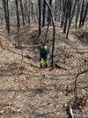
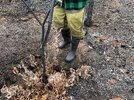
Ron visited the site with a friend, and I visited the site yesterday with him, as I was interested in this concept of ‘inverted topography’ inherent in our coastal plain. Here at this mine, they took out sandstone for various uses. Probably for chimneys, foundations, walls, and whatever. They had no other handy source for rock back then. When we got there, I was surprised to see how much they actually dug out. I don’t suppose they had heavy machinery back in the 1800’s, likely just mules and hand tools.

I have no knowledge of geology (regrettably), so I had the urge to read up on how the sandstone came to be found on hills such as this. I tried reading some professional papers but my mind got foggy. I did find a more digestible explanation in a newsletter put out by the New Jersey Geological Survey, Department of Environmental Protection.

Very basically, these deposits were laid down by old river courses 8 to 10 million years ago as they washed across our flat coastal plain after the oceans receded. Further along in time, local streams cut river valleys around these harder deposits and the old river bottoms became our hills and ridges of sandstone. I think it would be great if a geologist and an artist got together and portrayed this sequence of events graphically. I tried to simplify it so I could understand it better, I may not have it right, so here below you can read it yourself.

v1n2.pdf (nj.gov)

This is a neat place to take your kids and give them a basic understanding of why this happened while they run around in the holes exploring. Not easy to get to if you don't drive in the woods often, but the sand roads make hiking easy. You should use a GPS.

PS: I use the term for this aggregate as sandstone for convenience only because I don't know the formal name for what I assume to be termed "Beacon Hill" deposits.

1708693447263.png


1708693488985.png


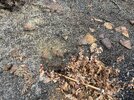
The large set of diggings I've circled are about 500 feet long by 100 feet wide. Photos will follow in next post.

1708693614724.png
 
Last edited:

bobpbx

Piney
Staff member
Oct 25, 2002
14,218
4,317
Pines; Bamber area
These photos give some perspective of how deep the holes are. You can stand in some and not be seen. The last photo shows Ron standing on a huge stone. There of course are many still underground.
 

Attachments

  • IMG_1258.JPG
    IMG_1258.JPG
    5.5 MB · Views: 60
  • ww.jpg
    ww.jpg
    473.7 KB · Views: 60
  • IMG_1261.JPG
    IMG_1261.JPG
    7.2 MB · Views: 52
  • IMG_1262.JPG
    IMG_1262.JPG
    6.5 MB · Views: 60

66C10

Scout
Aug 4, 2023
78
167
South Vineland
Very cool. Behind my parent's house in Vineland is a field that has hundreds of these stones around the edges of the field from the farmer removing them while working the field.
 

bobpbx

Piney
Staff member
Oct 25, 2002
14,218
4,317
Pines; Bamber area
Very cool. Behind my parent's house in Vineland is a field that has hundreds of these stones around the edges of the field from the farmer removing them while working the field.
And yet the field is quite level, not a hill? Makes me wonder if they were from the Bridgeton formation cited in the article.
 
  • Like
Reactions: 66C10

bobpbx

Piney
Staff member
Oct 25, 2002
14,218
4,317
Pines; Bamber area
  • Like
Reactions: 66C10

Boyd

Administrator
Staff member
Site Administrator
Jul 31, 2004
9,548
2,807
Ben's Branch, Stephen Creek
it’s also on the 1885 Cook Topo Map

Meant to comment on this earlier... Digital mapping has evolved into something that nobody could have imagined back in 1985, let alone 1885. These maps were intended to be looked at individually, not stitched together into a seamless map on a computer screen. I arbitrarily chose the dates shown on the map menu to place them in history but the reality is much more complicated. My version of the Cook Topo is sort of a "Frankenmap" pieced together as follows:

Screen Shot 2024-02-23 at 8.46.22 PM.png


IIRC, Vermeule map didn't require this kind of surgery, but there were over 50 individual maps with dates spanning the period 1870-1887.
 
  • Like
Reactions: bobpbx

bobpbx

Piney
Staff member
Oct 25, 2002
14,218
4,317
Pines; Bamber area
Meant to comment on this earlier... Digital mapping has evolved into something that nobody could have imagined back in 1985, let alone 1885. These maps were intended to be looked at individually, not stitched together into a seamless map on a computer screen. I arbitrarily chose the dates shown on the map menu to place them in history but the reality is much more complicated. My version of the Cook Topo is sort of a "Frankenmap" pieced together as follows:

View attachment 22079


IIRC, Vermeule map didn't require this kind of surgery, but there were over 50 individual maps with dates spanning the period 1870-1887.
This reminds me Boyd. When I was fooling around trying to figure out which rectangles to look at on the Vermeule historical map on Bens site, he has #85 missing, or I'm missing something.
 
  • Like
Reactions: Boyd

smoke_jumper

Piney
Mar 5, 2012
1,528
1,061
Atco, NJ
Very cool Bob. That area kind of reminds me of another location that I’ve been meaning to check out.
Here:

I’ve often wondered what was being mined out of here. The road leading to it could still be seen on the 1930’s aerial but it’s long gone now. I was always kind of thinking it might have been clay since slightly to the east looks like a bunch of tar kilns( also an area I’ve been meaning to check out). I was was also thinking possibly iron ore but it seems pretty remote.
 
  • Like
Reactions: Boyd

Teegate

Administrator
Site Administrator
Sep 17, 2002
25,647
8,251
Bob and Ron.... Jess and I made it there today. We visited all of the disturbed area's and checked them out.
 
  • Like
Reactions: bobpbx

bobpbx

Piney
Staff member
Oct 25, 2002
14,218
4,317
Pines; Bamber area
Very cool Bob. That area kind of reminds me of another location that I’ve been meaning to check out.
Here:

I’ve often wondered what was being mined out of here. The road leading to it could still be seen on the 1930’s aerial but it’s long gone now. I was always kind of thinking it might have been clay since slightly to the east looks like a bunch of tar kilns( also an area I’ve been meaning to check out). I was was also thinking possibly iron ore but it seems pretty remote.
We went by that one on a PBX explore John. Maybe I can come with you and your son if you go check it out. That's a wonderful area to be in.
PS: that is an awfully low spot for this kind of stone.

Guy, you have a video in post (3?) of Ted in the link below. Do you still have that one?

 
Last edited:

Teegate

Administrator
Site Administrator
Sep 17, 2002
25,647
8,251
The very northern area of the large disturbed area Bob and Ron visited, and I visited today, was owned in 1984 by someone named S. Baron. That is Block 79 Lot 6. I will work on finding more info. I have other info but it does not correspond to other things I am seeing so I won't post it as my other info may be wrong.

Screenshot 2024-02-25 at 5.47.16 PM.png
 

bobpbx

Piney
Staff member
Oct 25, 2002
14,218
4,317
Pines; Bamber area
By the way, in looking at John's area by Jemima Mount, I found something useful if you use Edge (and maybe others). I wanted to try and track the roads that go by Jemima in the 2024 MAP they propose, but there are no landmarks on that map. So I opened the 2024 MAP on this site (Ben's), and right clicked on the current tab for that map in the top bar of Edge and chose "open in side bar". Then I opened Boyd's Map, and they were side by side.

1708902585758.png
 
  • Like
Reactions: RednekF350

smoke_jumper

Piney
Mar 5, 2012
1,528
1,061
Atco, NJ
We went by that one on a PBX explore John. Maybe I can come with you and your son if you go check it out. That's a wonderful area to be in.
PS: that is an awfully low spot for this kind of stone.
When you went by did you actually go through it? Also I figured it was low for that type of rock, that’s why I was thinking possibly clay. What do you think was mined from there? Maybe we can meet up and check it out. The last two weekends we got out quite a bit.
 

bobpbx

Piney
Staff member
Oct 25, 2002
14,218
4,317
Pines; Bamber area
When you went by did you actually go through it? Also I figured it was low for that type of rock, that’s why I was thinking possibly clay. What do you think was mined from there? Maybe we can meet up and check it out. The last two weekends we got out quite a bit.
No, we did not get to that spot. If you look at the trip link, it shows where we planned to cross by. As to what they are, it's odd that the road has a go-around there, right? Maybe they just stole dirt from there to fill in a very wet road.
 
  • Like
Reactions: smoke_jumper

smoke_jumper

Piney
Mar 5, 2012
1,528
1,061
Atco, NJ
No, we did not get to that spot. If you look at the trip link, it shows where we planned to cross by. As to what they are, it's odd that the road has a go-around there, right? Maybe they just stole dirt from there to fill in a very wet road.
I thought of that as well. Exactly why it’s on my list to explore I have a lot of questions. I’m thinking that the road would be raised at least a little if they were using it for fill. Maybe the the go around was to get by while they loaded wagons.
 
Top