All,
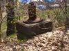
A while back I posted about a hike that members of the Pine Barrens Explorers (PBX) hiking club went on that was called "Half Dry, Half Wet, All Wild". On the very start of this hike BobM stumbled on a cement slab with bolts sticking out of it, and I mentioned that I had found them throughout the pines and felt they were the locations where saws were used for logging. They would just just move on leaving the cement slab when the wood ran out.
Here is a photo of the one Bob found. You can see one of the bolts right next to the stick.
http://www.njpinebarrens.com/teegate/main.php/download/996-1/IMG_6038.jpg
I was reading an article in the Batsto Citizens Gazette from the fall of 1971, and one of the articles caught my attention. It was I am assuming written by Bud Wilson, since the author is J.G.Wilson. The article is on sawmills and it tells me that my assumption was correct on what the cement slab actually was. Remember, we were at Hawkins Bridge.
Here is an excerpt.
***
Such Mills and the traces of them have been located at Penn Swamp at a spot near High Crossing, another near Godfrey's Bridge, ONE AT HAWKINS BRIDGE and other places. There was one on the road from Atsion to Quaker Bridge, about halfway between Atsion and the bog.
All of the mills whose remains can be found today embodied the same engineering. A brick, stone, and concrete platform or base in which were imbedded (and still visible) long threaded rofs. These were actually bolts that secured the heavy steam or donkey engine.
***
Now this particular slab had short bolts, so I am guessing it is of a much more recent construction with more modern equipment being used that required smaller bolts.
The article mentions how it was easier to move the machine that to build a new mill. It also has a very long description on one sawmill at Sandy Ridge with information from someone who worked there. The wood was carted to the JCRR near Carranza road and loaded on the train. The pile of sawdust was well over 100 yards long and two stories high. It was later removed completely for mulch by Blueberry growers.
And FYI for the members of PBX, there is another article that briefly discussed the canal we discussed in depth near Atsion Lake.
Guy