
You are using an out of date browser. It may not display this or other websites correctly.
You should upgrade or use an alternative browser.
You should upgrade or use an alternative browser.
No, I was not looking for anything in particular, just wondering if something stood out.
Guy
Guy:
No, not really. In fact, I remember thinking to myself how few structures existed east of Davis Grove. The draftsmen who prepared the SHD drawings depicted almost nothing except trees, foilage, and vegetation adjacent to the roadway east of the filling station and even more so east of Four Mile Circle.
I also examined a nice blueprint map of Chatsworth, although it had become brittle at some point and someone who did not know any better attempted a repair with old-fashioned Scotch Tape—a very bad move!! One of the envelopes I pulled also contained a survey from Apple Pie Hill. When you can afford to take some time off, Guy, I would be happy to show you how to research these drawings and filed plans.
Best regards,
Jerseyman
Guy:
When you can afford to take some time off, Guy, I would be happy to show you how to research these drawings and filed plans.
Anytime from mid July on is good for me. You tell me when you are going there, and with a day or two notice I will go with you. If possible Fridays are best, but any day is acceptable.
Guy
Anytime from mid July on is good for me. You tell me when you are going there, and with a day or two notice I will go with you. If possible Fridays are best, but any day is acceptable.
Guy
Sounds good, Guy! While we are at it, I will show the ropes vis-à-vis title-searching. Then you’ll be qualified to do so just about anywhere! We’ve been talking about doing this training for a long time—so this coming July is the time to “get ’er done.”
Best regards,
Jerseyman
A
anghew025
Guest
To All;
I am happy to announce that we can all OFFICIALLY put this mystery to bed!!!!! I have in my possession this day, found in a box of old papers from my father belonging at some point in the past to my Great-grandfather, a Dealer Sales Contract from Shell Oil Co. to sell gas and oil product to one Thomas R. James! The location of the filling and service station, written by my GG's own hand, was "Burrs Mills & Route 40, Vincentown, NJ". (this'll turn your stomach---he sold Shell's "Super Ethyl Gasoline" for----are you sitting?---2 & 1/2 cents!) The contract was for one year, from July 1934 to July 1935. The only real question now is, why is there Gulf signage all over in the picture?
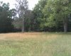
I, along with my wife and 2 boys, drove out to the area that Jerseyman discovered the other day on Saturday afternoon. By using the aerial map that J-man and TeeGate worked out, I drove to Burrs Mill Rd from Four-Mile Circle. (BTW, WHY is it called Four-Mile Circle? It certainly isn't four mile away from anything.) I did a U-turn on Burrs Mill and headed back about a half mile, according to the maps, and came to an open patch of land on the north side of Rt.70. Lisa and I took some pictures, walked around the land and tried to visually scope out the trees and all, just to try and take some mental notes.
After leaving there, and before finding this contract, I really had my doubts. My Dad swore and still thinks that there is a building, or at least a foundation there. Also, and maybe someone can explain why, I could never see any type of structure in this area on any of the aerial maps from 1930. That made me skeptical. Where did the buildings or the pump island go? But, Jerseyman CLEARY found it on the blueprints from the state. Thankfully, with todays lovely little discovery, all of my questions, except one, are put to rest.
That question is this, is it "possible", that the station was closer, if not on, the corner of Burrs Mill & Rt.40/70? I'm just wondering.
Thanks again to everyone here for helping out to figure this mystery out. I would have never been able to have a clue where to begin if it wasn't for you all. I am indebted.
As far as this forum, consider me a local. This website is for now on in my favorites, and I will be checking the group BS sessions for any new detecive stories. I hope I will be able to help someone out the way you all helped me.
Thank you all again!
Doug
P.S- If you look in the original picture, you can see in the back, in front of the outhouse, a tree that has two trunks, or, its split. That tree is still there. Also, Lisa found in the grass, a piece of concrete. She said its a piece of one of the buildings or the gas island. I dont know if its true, but I say it is, and no one convincing me differently....")
I am happy to announce that we can all OFFICIALLY put this mystery to bed!!!!! I have in my possession this day, found in a box of old papers from my father belonging at some point in the past to my Great-grandfather, a Dealer Sales Contract from Shell Oil Co. to sell gas and oil product to one Thomas R. James! The location of the filling and service station, written by my GG's own hand, was "Burrs Mills & Route 40, Vincentown, NJ". (this'll turn your stomach---he sold Shell's "Super Ethyl Gasoline" for----are you sitting?---2 & 1/2 cents!) The contract was for one year, from July 1934 to July 1935. The only real question now is, why is there Gulf signage all over in the picture?
I, along with my wife and 2 boys, drove out to the area that Jerseyman discovered the other day on Saturday afternoon. By using the aerial map that J-man and TeeGate worked out, I drove to Burrs Mill Rd from Four-Mile Circle. (BTW, WHY is it called Four-Mile Circle? It certainly isn't four mile away from anything.) I did a U-turn on Burrs Mill and headed back about a half mile, according to the maps, and came to an open patch of land on the north side of Rt.70. Lisa and I took some pictures, walked around the land and tried to visually scope out the trees and all, just to try and take some mental notes.
After leaving there, and before finding this contract, I really had my doubts. My Dad swore and still thinks that there is a building, or at least a foundation there. Also, and maybe someone can explain why, I could never see any type of structure in this area on any of the aerial maps from 1930. That made me skeptical. Where did the buildings or the pump island go? But, Jerseyman CLEARY found it on the blueprints from the state. Thankfully, with todays lovely little discovery, all of my questions, except one, are put to rest.
That question is this, is it "possible", that the station was closer, if not on, the corner of Burrs Mill & Rt.40/70? I'm just wondering.
Thanks again to everyone here for helping out to figure this mystery out. I would have never been able to have a clue where to begin if it wasn't for you all. I am indebted.
As far as this forum, consider me a local. This website is for now on in my favorites, and I will be checking the group BS sessions for any new detecive stories. I hope I will be able to help someone out the way you all helped me.
Thank you all again!
Doug
P.S- If you look in the original picture, you can see in the back, in front of the outhouse, a tree that has two trunks, or, its split. That tree is still there. Also, Lisa found in the grass, a piece of concrete. She said its a piece of one of the buildings or the gas island. I dont know if its true, but I say it is, and no one convincing me differently....
A
anghew025
Guest
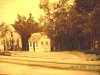
Here is a current picture from yesterday. If you compare it to the original one it is very cool how you see the tree with the double trunk on the RIGHT hand side in BOTH pics. Also, on the new pic you see a huge tree right smack in front which coincides with a little tree growing right in front of the house on the corner.
Attachments
A
anghew025
Guest
A
anghew025
Guest
After doing a quick recheck of the photo Jerseyman posted, I am beginning to think the station was closer to Beebe Lane than the link I posted. Here is why. In the below photo you can see that the two area’s in yellow say 52’. So the distance between the yellow lines is 104’. The distance from the two green lines which is Beebe Lane and the center of the pumps is about three times that at about 312’. That would put the station here.
http://maps.njpinebarrens.com/#lat=39.888974&lng=-74.653238&z=17&type=nj1930&gpx=
http://maps.njpinebarrens.com/#lat=39.888974&lng=-74.653238&z=19&type=k&gpx=
This is all assuming Beebe Lane is the road shown in the map. I doubt it is the main intersection nearby that goes to Burrs Mill because that road comes in perpendicular to 70 and the map shows differently.

Guy
http://maps.njpinebarrens.com/#lat=39.888974&lng=-74.653238&z=17&type=nj1930&gpx=
http://maps.njpinebarrens.com/#lat=39.888974&lng=-74.653238&z=19&type=k&gpx=
This is all assuming Beebe Lane is the road shown in the map. I doubt it is the main intersection nearby that goes to Burrs Mill because that road comes in perpendicular to 70 and the map shows differently.
Guy
Why is it that the blueprint shows Burrs Mill road going on a Northeast angle to 70, but in reality it is a 90 degree road (even in the 1931 arial)?
A
anghew025
Guest
I think that it could be Burrs Mill Rd drawn at an incorrect angle. But I can only base that on one observation...Bebee Lane does not cross over on the south side on Rt40/70. But I'm lucky if I can tie my own shoes let alone read a blueprint from 1930...
Doug
Doug
Bob, Doug, Guy, et al.:
I have several books ordered from the storage center in Westampton, so I WILL be returning to the Burlington County Clerk’s Office this week. When I go back—probably today or tomorrow—I will photocopy the entire drawing depicting the Davis Grove filling station and eliminate any ambiguity concerning its location.
Best regards,
Jerseyman
To All;
I am happy to announce that we can all OFFICIALLY put this mystery to bed!!!!! I have in my possession this day, found in a box of old papers from my father belonging at some point in the past to my Great-grandfather, a Dealer Sales Contract from Shell Oil Co. to sell gas and oil product to one Thomas R. James! The location of the filling and service station, written by my GG's own hand, was "Burrs Mills & Route 40, Vincentown, NJ". (this'll turn your stomach---he sold Shell's "Super Ethyl Gasoline" for----are you sitting?---2 & 1/2 cents!) The contract was for one year, from July 1934 to July 1935. The only real question now is, why is there Gulf signage all over in the picture?
I, along with my wife and 2 boys, drove out to the area that Jerseyman discovered the other day on Saturday afternoon. By using the aerial map that J-man and TeeGate worked out, I drove to Burrs Mill Rd from Four-Mile Circle. (BTW, WHY is it called Four-Mile Circle? It certainly isn't four mile away from anything.) I did a U-turn on Burrs Mill and headed back about a half mile, according to the maps, and came to an open patch of land on the north side of Rt.70. Lisa and I took some pictures, walked around the land and tried to visually scope out the trees and all, just to try and take some mental notes.
After leaving there, and before finding this contract, I really had my doubts. My Dad swore and still thinks that there is a building, or at least a foundation there. Also, and maybe someone can explain why, I could never see any type of structure in this area on any of the aerial maps from 1930. That made me skeptical. Where did the buildings or the pump island go? But, Jerseyman CLEARY found it on the blueprints from the state. Thankfully, with todays lovely little discovery, all of my questions, except one, are put to rest.
That question is this, is it "possible", that the station was closer, if not on, the corner of Burrs Mill & Rt.40/70? I'm just wondering.
Thanks again to everyone here for helping out to figure this mystery out. I would have never been able to have a clue where to begin if it wasn't for you all. I am indebted.
As far as this forum, consider me a local. This website is for now on in my favorites, and I will be checking the group BS sessions for any new detecive stories. I hope I will be able to help someone out the way you all helped me.
Thank you all again!
Doug
P.S- If you look in the original picture, you can see in the back, in front of the outhouse, a tree that has two trunks, or, its split. That tree is still there. Also, Lisa found in the grass, a piece of concrete. She said its a piece of one of the buildings or the gas island. I dont know if its true, but I say it is, and no one convincing me differently....
Doug:
That is GREAT documentation you found!! I suspect that the Gulf signage represents either the previous or subsequent products dispensed at that location. Since the words “Davis Grove” are on the roof of the small building, I would guess Gulf to be the previous product dispensed since Davis acquired the property in 1932. Back in the day when individuals owned service stations rather than the oil companies or wholesalers, you could contract to dispense whatever products you wished. I have books in my library about old gas stations and many of them sold three and four different brands of petroleum products.
I recall an old friend of the family who owned a service station in the Fairview section of Camden. He sold ESSO products and one day in the 1960s, some trucks rolled up and they began to change all of his signage to EXXON. He yelled at them and threw them off the property because he also owned the signs! It took the oil company rep about six months to convince Charlie that changing out the signs was a good idea. When Charlie retired, he sold the service station to Wawa and they tore it down and put a convenience store. Such are the ebbs and flows of life.
Best regards,
Jerseyman
lol Now look...I was busy editing as I posted the wrong picture originally.
Doug:
Does this mean you have more than one photo of the place? Or, is the image originally posted not the full photograph? Please post whatever you have available!!
Best regards,
Jerseyman
Why is it that the blueprint shows Burrs Mill road going on a Northeast angle to 70, but in reality it is a 90 degree road (even in the 1931 arial)?
Bob (and Guy):
I will post more of the drawing after I copy the entire sheet. Meanwhile, the deed for the property indicated it was so many feet from a monument in the center of the Bozarthtown-Burrs Mill Road, which, I do not believe, is the same as the modern Burrs Mills Road. Hence, the angled crossing. All will be resolved when next I visit the clerk’s office. While I am at it, I will copy the deed as well!
Best regards,
Jerseyman
After doing a quick recheck of the photo Jerseyman posted, I am beginning to think the station was closer to Beebe Lane than the link I posted. Here is why. In the below photo you can see that the two area’s in yellow say 52’. So the distance between the yellow lines is 104’. The distance from the two green lines which is Beebe Lane and the center of the pumps is about three times that at about 312’. That would put the station here.
http://maps.njpinebarrens.com/#lat=39.888974&lng=-74.653238&z=17&type=nj1930&gpx=
http://maps.njpinebarrens.com/#lat=39.888974&lng=-74.653238&z=19&type=k&gpx=
This is all assuming Beebe Lane is the road shown in the map. I doubt it is the main intersection nearby that goes to Burrs Mill because that road comes in perpendicular to 70 and the map shows differently.
Guy
Good calculations, Guy! Your comment about the station’s location vis-à-vis Burr’s Mill Road or Beebe Lane is why I indicated you should move your marker eastward on the 1931 aerial in a previous posting. But the full drawing will clear up any doubts!!
Best regards,
Jerseyman
A
anghew025
Guest
The original photo we have is an old black and white negative that we had blown up into a large framed photo. I can't scan the negative so I was only left with the option to take a photo of the large framed photo, which caused me to lose alot of the sides of the original. Thats why the thumbnail is missing the left hand main building, but it also includes the outhouse that the original post did not.
After doing a quick recheck of the photo Jerseyman posted, I am beginning to think the station was closer to Beebe Lane than the link I posted. Here is why. In the below photo you can see that the two area’s in yellow say 52’. So the distance between the yellow lines is 104’. The distance from the two green lines which is Beebe Lane and the center of the pumps is about three times that at about 312’. That would put the station here.
http://maps.njpinebarrens.com/#lat=39.888974&lng=-74.653238&z=17&type=nj1930&gpx=
http://maps.njpinebarrens.com/#lat=39.888974&lng=-74.653238&z=19&type=k&gpx=
This is all assuming Beebe Lane is the road shown in the map. I doubt it is the main intersection nearby that goes to Burrs Mill because that road comes in perpendicular to 70 and the map shows differently.
Guy
Guy, If you're not spot on, then I believe you're darn close. Take a look at the USGS Pemberton Quad http://gallery.njpinebarrens.com/showphoto.php/photo/5284 and focus on the road coming from the Ongs Hat area, around what I think are the clearings to the north and then to Burrs Mill.
PS, great investigative work to you all. I am thankful for the talent in these forums.
Jeff