Absolutely. No McWeather for me!Weather 'announcements' have become similar to clickbait. They use it to keep you watching and interested. It's why ABC nightly news starts off every broadcast with "we are monitoring deadly weather at (insert a bundle of states)". They oversell it.

Wet Forest - Formerly Known as Dry Forest
- Thread starter dragoncjo
- Start date
You are using an out of date browser. It may not display this or other websites correctly.
You should upgrade or use an alternative browser.
You should upgrade or use an alternative browser.
Not even a hint of any rain for the next week. I mean, it's hard to complain about a sunny day, but it's gonna get really dry here if this forecast is right...


If that happens this year, my little piece Stephen Creek will be dry long before November. It will be really low if we go a full week without rain.
it's gonna get really dry here if this forecast is right...
Happily, it was wrong (at least for me, here). Even though the forecast said 30% chance of 1/10 inch, we got a lot more, starting around 6:00 PM yesterday. Rained hard for maybe 5 minutes, then tapered off but the light rain continued for quite awhile. The color of the markers on Rutgers site show the storm path pretty well, the yellow ones close to me are a little over 3/4 inch and that looks right.
Today's storm came right through here and it's been raining for the past couple hours, seems to be letting up now and getting brighter but there was just a very loud thunder-clap. Although it lasted a long time, has been pretty light, will head out and have a look soon... the sun just now came out again.
The hype for this impending tropical storm/hurricane has begun. They have it colored yellow on their aerials now, but soon it will be an angry red color to amp up the hysteria so they tune in to see ads.
I got about 1/2 inch yesterday, so that makes more than one inch over the past two days. The week that was forecasted as completely dry has been the wettest I've had in awhile.

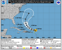
The forecasts I've seen all say that it will turn North and miss the US East Coast, but maybe it will bring us more rain?
"The probability of a landfall from Erin along the U.S. East Coast is low at this time. However, interests along the East Coast should continue to monitor this system for possible changes. Erin will generate high surf and dangerous rip currents along the U.S. East Coast next week, no matter where it tracks."
 weather.com
The hype for this impending tropical storm/hurricane has begun.
The forecasts I've seen all say that it will turn North and miss the US East Coast, but maybe it will bring us more rain?
"The probability of a landfall from Erin along the U.S. East Coast is low at this time. However, interests along the East Coast should continue to monitor this system for possible changes. Erin will generate high surf and dangerous rip currents along the U.S. East Coast next week, no matter where it tracks."
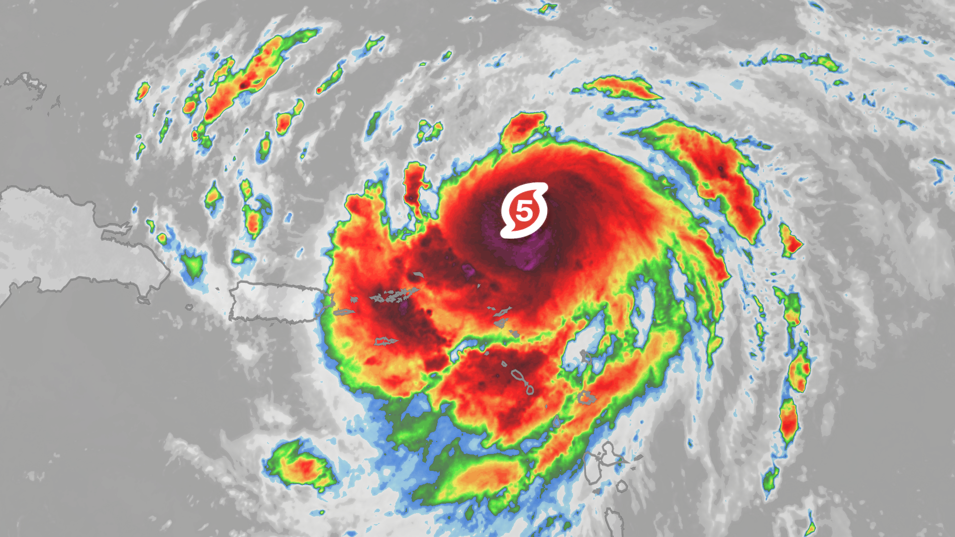
Erin Remains A Category 5 Hurricane | Weather.com
Erin, the first hurricane of the season, is now a powerful Category 5 hurricane. Here's where it could head in the week ahead.
Last edited:
FWIW, I really haven't seen any "hype" for this storm yet myself. Would not be surprised if it exists, but I haven't seen it - for example, CNN did a report this morning and said no landfall was expected and the whole thing seemed pretty matter-of-fact.
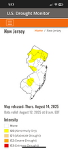
Trying to reconcile this severe weather outlook with our local forecast.... I checked a number of spots around Southern NJ and the local forecasts are all about the same as this. Place your bets.... which version do you choose? 
_____________________________________________________________________________

_____________________________________________________________________________
This Afternoon: Sunny, with a high near 90. Southwest wind around 10 mph.
Tonight: A chance of showers and thunderstorms between 10pm and 2am, then a slight chance
of showers. Partly cloudy, with a low around 69. South wind around 5 mph becoming northwest
after midnight. Chance of precipitation is 30%. New rainfall amounts of less than a tenth of an inch,
except higher amounts possible in thunderstorms.
_____________________________________________________________________________When I want to see what the weather forecasters really think, I visit the “Forecast Discussion” page on the NWS. This presents the data, without any exaggerated guesses on the weather. It can be very ”weather technical” at times and provides a well informed forecast based on the current conditions. Here’s a sample for todays weather.
NEAR TERM /THROUGH MONDAY/...
Latest satellite loop showing cumulus field developing over
southeastern PA and interior Delmarva/NJ as surface temperatures
rise into the upper 80s and lower 90s. As a cold front moves
into this airmass later this afternoon and evening, scattered
convection will form and move to the east and southeast roughly
between 22Z and 02Z. Hi-res guidance showing most places will
have little to no rainfall but where storms do form there is the
potential for brief 40 to 50knot wind gusts and a quick
torrential downpour.
Any convection after 02Z will dissipate or move offshore by
late evening with the cold front to follow
as it moves through
NW to SE late evening into the overnight. Winds shift from SW
to N/NE around 06Z with a low stratus deck likely setting up.
Lows by Monday morning look to range from around 60 north to
around 70 near the urban corridor, most of Delmarva, and coastal
areas.
Monday looks to be sharply cooler compared to Sunday as northeast
flow and low status persist in the wake of the cold front. The cold
front will stall across southern Virginia and since it will
remain in our proximity, there may be some lingering spotty
showers around. Otherwise the big story will be the cooler
temperatures and lower dew points. In fact much of the area
looks to see highs not getting out of the 70s under mostly
cloudy skies.
Some storms in PA right now, they appear to be headed (more or less) towards us, so I guess we'll know what happens in a little while...

I'd love to see some rain, but a high of 74 tomorrow makes me happy!
That approaching storm initially looked like it would hit me, but it split into a North and South section and both missed. Just got back from my evening walk, cloudy sky, muggy and dead calm without a breath of air moving. There's more rain in PA now that might hit me later. Maybe...
I believe it will just miss me as well. Maybe...That approaching storm initially looked like it would hit me, but it split into a North and South section and both missed. Just got back from my evening walk, cloudy sky, muggy and dead calm without a breath of air moving. There's more rain in PA now that might hit me later. Maybe...