another "what is this area"?

stizkidz

Piney
May 10, 2003
1,044
8
Tuckerton
Drove from Tuckerton to Hammonton yesterday morning. Hardly passed another soul on a warm Sunday morning through the Pines.

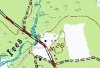
Passed by the Ives branch and noticed a small cleared area on the state forest side with a sand trail headed into the woods. Looked it up when I got home and noticed an indication of structures on the Topo.

What was this place?
 

Attachments

  • ives-area.jpg
    ives-area.jpg
    80.4 KB · Views: 304

Boyd

Administrator
Staff member
Site Administrator
Jul 31, 2004
9,551
2,809
Ben's Branch, Stephen Creek
How about some kind of clue as to where you're talking about, like a link to the NJPB maps or even a hint such as what road you were on? :)
 

stizkidz

Piney
May 10, 2003
1,044
8
Tuckerton
Boyd, forgive me for not posting the coordinates. In case this was a sensitive area, I wanted to make the coordinates somewhat tough to track down.

I posted a pic of the map but now that I look at it, it doesn't show enough for anyone to figure it out.

The road shown on the map is Hammonton Road between New Gretna and Chips Folly/Bridgeport on the Ives Branch.
 

Teegate

Administrator
Site Administrator
Sep 17, 2002
25,656
8,266
Ed,

Your link is at the wrong place I believe. They are referring to the area south of there along 679.
 

ecampbell

Piney
Jan 2, 2003
2,844
967
My link is where I crossed and there was unusual structure, the Ives is interesting. Look at the historical aerials at that spot. When we passed by there was someone was running a weed whacker by the clearing. I plan to explore there, just look at the names of the many branches.
 

Teegate

Administrator
Site Administrator
Sep 17, 2002
25,656
8,266
The gun club that was there was the Highland Park Field and Stream club. There is a well where your link is at. Check it out on our PBX visit there at the below link. The day we visited was when the stick in my ear was getting so bad I made the decision to go to the doctors. I did not know it was there and it was bouncing up and down as I walked.

http://forums.njpinebarrens.com/threads/the-march-of-ives-a-pbx-hike.4277/
 

Teegate

Administrator
Site Administrator
Sep 17, 2002
25,656
8,266
Make sure you go back behind where the club was at and take notice they cut a ton of trees down. I would have to assume the person you saw may be one of the owners.

IMG_2285.JPG


Guy
 

Teegate

Administrator
Site Administrator
Sep 17, 2002
25,656
8,266
I just realized your link is south of the area I am referring to. Oh well.

Guy
 

Teegate

Administrator
Site Administrator
Sep 17, 2002
25,656
8,266
Gibby's map link is the place I am referring to. I will take a short trip out there and see what I can find.

I have been there often. Al and I meet there when exploring in that area. There are ruins right along the road. If you look at HistoricAerials at the below link you can see that by 1951 there was a field cut which appears to be a farm.

http://www.historicaerials.com/aeri....6135681324135&lon=-74.486141826177&year=1963

If you go there now the field has been planted with tress and it is a wonderful place to roam around in. I have photo's and will look for them.

Guy
 

Pinesbucks

Explorer
Apr 15, 2013
295
111
Maybe this was part of the Petrecca property. This was donated to the state. They now have a special use area for disabled hunters and youth. Here is the information from the state website. The Wading River Special Use Area, formerly known as the Petrecca property, was donated to the Division by Charles Petrecca and Mary H. Petrecca. Work to control the extensive phragmites on the site was initiated in 2005 with funding provided by the US Fish and Wildlife Service and Ducks Unlimited.
http://www.state.nj.us/dep/fgw/wadingriverblinds.htm
 

stizkidz

Piney
May 10, 2003
1,044
8
Tuckerton
Bucks, thank you kindly for the information. I was unaware of such a WMA. The area in question is on the other side of Hammonton Rd.
 

Pinesbucks

Explorer
Apr 15, 2013
295
111
Sorry about that I thought maybe they were somehow connected. Tee the picture of the downed trees was that at the highland park gun club site?
 

Teegate

Administrator
Site Administrator
Sep 17, 2002
25,656
8,266
Yes, it has been and started as confusing, but interesting none the less.
I believe the first post is referring to this location.
http://maps.njpinebarrens.com/#lat=39.613821475380355&lng=-74.48739051818847&z=16&type=topo&gpx=
I found it by taking a virtual paddle down the Ives from where it crosses the Batona Trail, the location in my post.

Yes, that is the location where Al and I meet when stone searching in that area. The "cave" location that I posted about is somewhat nearby. There also is another area further in the woods that had some sort of dwelling I would expect.

All of the confusion was my fault.

Guy
 
Top