Probably a stupid question, but can someone tell me the difference between these two roads? The paved road is outlined with the solid black line. The other road is outlined in solid beige/brown. I've been on the road outlined in solid black, and it is paved.

Boyd's map legend question
- Thread starter Badfish740
- Start date
You are using an out of date browser. It may not display this or other websites correctly.
You should upgrade or use an alternative browser.
You should upgrade or use an alternative browser.
Which roads? ")
The heirarchy of roads on my maps is something like this.
Major US/State Highway
County Route
Minor road
Unpaved road
trail (narrow unpaved road)
hiking trail
But the original data I used only contained the following
Major US/State Highway
Minor road
So I hand-edited the roads to try to make them match what I believe to be correct. In the pines I relied on my own experience and aerial photos. There are plenty of errors. And there are hold-overs from that original data where unpaved roads still show as paved roads.
I am using all new data from the state for my 2013 revised map and it recognizes more classes of roads, like minor county routes and major county routes. It also is supposed to be accurate within +/- 1 foot. But the state data doesn't have any unpaved roads and also doesn't have a number of little streets inside developments. So it's a big job to reconcile the new and old road data - one of the reasons why the 2013 map may end up as a 2014 map.
Gotcha-I've been using your map along with NJPB maps to figure out a couple of roads up in High Point State Park that are interesting. They branch off of one of the major roads in the area (Deckertown Turnpike) and traverse the eastern slope of the Kittatinny Ridge, ending at a local road. One of the more interesting aspects of the road is that it seems to traverse a small bridge over a small pond on the mountainside-take a look at the NJPB topo view:
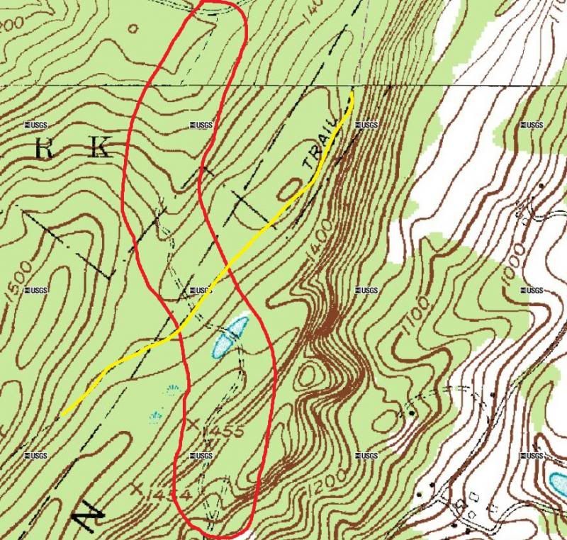
The road in question is circled in red. The yellow line is the Appalachian Trail. Since the pond is so close to the Appalachian trail I should probably do a little research on the section. I'm just puzzled as to why there would be a bridge over a little pond like that. I suppose it could just be a swamp that the road goes right through, maybe on a section of built up land, but it would have to be man made, so who made it and why?
The historic topo depicts the road but not the pond:
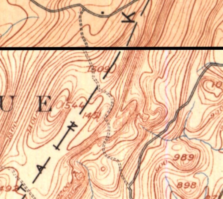
Here's how the pond appears on the satellite image:
http://maps.njpinebarrens.com/#lat=41.2437432579954&lng=-74.69037197503087&z=19&type=hybrid&gpx=
The road in question is circled in red. The yellow line is the Appalachian Trail. Since the pond is so close to the Appalachian trail I should probably do a little research on the section. I'm just puzzled as to why there would be a bridge over a little pond like that. I suppose it could just be a swamp that the road goes right through, maybe on a section of built up land, but it would have to be man made, so who made it and why?
The historic topo depicts the road but not the pond:
Here's how the pond appears on the satellite image:
http://maps.njpinebarrens.com/#lat=41.2437432579954&lng=-74.69037197503087&z=19&type=hybrid&gpx=
Betcha it is a pack of beaver's work 
There is another similar pond to the NE of that one, but it is a residential property.
There is another similar pond to the NE of that one, but it is a residential property.
Another factor could be the cartographer's license. That part of the state is dotted with a huge number of pond-like kettles (ponds resulting from ice-calving during glacial retreat). Like Pinelands spungs, mapmakers for convenience don't always add small ponds as important landscape features. They have to draw the line somewhere.
I provide as example the Skating Ponds (Ponds A & B) in the woods near my place. Both are mirror images of each other in size, depth, and hydrofill.

I provide as example the Skating Ponds (Ponds A & B) in the woods near my place. Both are mirror images of each other in size, depth, and hydrofill.
Views of the Skating Ponds (A & B) as depicted on four different images from NJPineBarrens Maps.
Pond C is a natural spung. Pond D is a borrow pit.
(from top left: 1931 aerial photomosics; modern base map, modern USGS topo map; 1889 USGS topo map)
I've taken pond outlines from the aerial record and transferred them to other maps. The fit is poor. Don't put too much faith in the accuracy of water features shown on these maps. Pond C has a way longer period of hydrofill than Pond D, yet does not appear on any map record I have ever seen. Only geeks like us care.
S-M
As it turns out, I didn't "find" anything The pond is part of a farm that was annexed by High Point State Park back in the 1980s. The bridge is a man made bridge that carries a trail over it that eventually intersects with the Appalachian Trail. Interesting nonetheless!
The pond is part of a farm that was annexed by High Point State Park back in the 1980s. The bridge is a man made bridge that carries a trail over it that eventually intersects with the Appalachian Trail. Interesting nonetheless!Just got back to the pines after 5 days in NYC....
Very interesting example Mark! NJDEP has some very good land use/land cover (LULC) data available at 1:12000 scale (4x the resolution of the 24k USGS topos), and that is what I have used in my maps: http://www.state.nj.us/dep/gis/lulc07cshp.html
Here's the same area from my beta NJ 2013 map. The aqua colored water data is from the USGS. The darker areas are from the NJDEP.
NJDEP shows your pond C and half of pond A. The USGS has the other half of pond A plus pond D. Now pond B is not shown at all, however notice that its location is still visible due to lack of forest cover and the presence of wetland data.
NJDEP is even showing us another pond (E) just across Pancoast Mill Rd from pond A.