Bunch of new outdoor products from Garmin

Pan

Explorer
Jul 4, 2011
555
246
Arizona
Boyd - Reading the reviews it seems that the new Montana still has some bugs, like

"Quote:


Originally Posted by Twohondas
So what do you think Dan does the Montana get the nod over your Zumo for Adv riding?

My zumo 660 is in the Truck. But don't jump to fast, the zumo is still a much better Auto-Routing GPS. The Montana has some "growing up" to do when it comes to Auto-Routing. No Recalculation = OFF. All Routes are recalculated by default and it will take some time to figure out the "Activity-based" routing preferences.

When they get the Routing a little better, the Montana will be THE Dual Sport and Adv Touring GPS. "

http://www.advrider.com/forums/showthread.php?t=688775&page=28

Someone else there mentioned that the auto routing was bad.

I'd like to know what my 276 can do that the Montana can't. One thing I believe is that it can store many more waypoints, but I have only a little more than 600 accumulated over the years, across the country, and Montana will hold more than that.

Thanks for the screen comparison. My 276 is still going strong so I can wait until the bugs are fixed and the price comes down (maybe), plus my lifetime map update can't be transferred to a new unit so I'd have to buy that again.

I use these things daily.

:)
 

Boyd

Administrator
Staff member
Site Administrator
Jul 31, 2004
9,548
2,807
Ben's Branch, Stephen Creek
Personally I call BS on all of that. My Montana has been rock solid reliable and I have used it every day for over two months. I don't doubt that some people are having problems, but I don't think you should leap to any conclusions based on that thread since there are many, many other happy owners. But with any Garmin product, it's always better to wait awhile before purchasing if you can, so they have a chance to work out all the bugs. In this case, it's still not clear to me whether the screen issue is hardware or software.
 

Pan

Explorer
Jul 4, 2011
555
246
Arizona
Good to hear that you like it because I was keeping it in mind for when my Garmin 276C gets replaced. I'd like to try to find/google-up a 276C owner who switched to the Montana so that I could get a direct comparison. Are there any things you particularly like or dislike about it, Boyd?
 

Boyd

Administrator
Staff member
Site Administrator
Jul 31, 2004
9,548
2,807
Ben's Branch, Stephen Creek
As with any Garmin product, there are strengths and weaknesses. But overall, I love this unit, it's my favorite of all the Garmin models I've owned (and there have been a lot... maybe 8 or 9). They have never made a unit with this many advanced features. The screen, in particular, is spectacular. It's the best transreflective touchscreen I've ever seen, easily visible in most conditions without even using the backlight.

For sure, there are bugs, but they don't really cause many problems for me. It's rather large, but that doesn't bother me personally and in fact I've come to like the size, even for hiking. Feels more like a handheld computer than a gps perhaps. Tracks I've recorded while hiking are not always as consistent as I like. But this might be a result of my homebrew carabiner setup which holds the unit upside down with the antenna at the bottom. That is the main disappointment for me, that Garmin has not provided a good belt clip for this model.

I'm not going to try and write a full review in this post though. I imagine that REI has them in stock by now, so you could go to a store and play around yourself. They also have a really liberal return/exchange policy so you wouldn't be risking much if you bought from them and didn't like it.
 

Spung-Man

Explorer
Jan 5, 2009
978
666
64
Richland, NJ
loki.stockton.edu
Thanks Boyd,

I've been inspired! The topic is timely, and nicely dovetails with a current arboricultural project I'm involved with. The wife's on her way to REI's Marlton store as I write. What is the spatial accuracy of the new units anyway, within a few meters?

S-M
 

Boyd

Administrator
Staff member
Site Administrator
Jul 31, 2004
9,548
2,807
Ben's Branch, Stephen Creek
Really, all modern consumer grade units have comparable accuracy which is typically +/- 5 meters. This should hold true for the cheap $150 eTrex H models through the $650 Montana 650t. To get better accuracy you need to make a big jump up to survey grade units from Trimble and now we're talking in the $5,000 ballpark. These will have features more oriented towards data entry, but won't be so user friendly and assume knowledge of GIS software which you will probably have to purchase separately.

It also depends on how you will use the unit. I have found that my Oregon makes more consistent tracks than my 60csx while hiking over the same trail repeatedly. But if I plant my 60csx on a property stake for an hour to average a waypoint, it is more accurate than the Oregon.

The Oregon, Dakota, Montana and GPSMap 62 series have all standardized on the STM Cartesio chipset while the existing eTrex series and newer production model 60csx use the MTK chipset. Older production 60csx units (like mine) use the SiRFStar chipset. Some people think SiRF is the "holy grail" but I am not convinced. From my tests, the SiRF chip produces more of a shotgun pattern of points if you place it stationary while the STM chips will produce a tighter pattern. However, if you average that shotgun blast from SiRF, you may get a more accurate position fix, which would explain in part why the 60csx does better in my stationary tests.

Another factor might be antenna design, and some people have sort of a religious devotion to the quad helix used on the 60csx and its updated version, the 62s.

Depends on what you need. I like the Montana because the map is the most important thing for me and no other handheld has a screen like it. It also has extended support for raster imagery that you can use to make your own "custom maps". It has capacity for 500 map tiles while other modern Garmin models only support 100 tiles. For example, if you used 1 foot per pixel resolution imagery (such as the excellent NJ 2007 orthoimagery), the Oregon and 62s would let you cover about a 2 mile x 2 mile area. The Montana can cover 5x as much as that.

I don't believe the new eTrex models are shipping yet and have not seen any in depth write ups. I think I read they will use the STM Cartesio however, as Garmin seems to be standardizing on it.
 

Teegate

Administrator
Site Administrator
Sep 17, 2002
25,647
8,251
Boyd does an excelent job of explaining all the differences of each unit, and there is no way I can explain it better than him. However, I have both the 60csx and the Oregon and I have found that without a doubt the 60csx will outpreform the Oregon when it comes to narrowing down a location as close as possible. But I prefer the Oregon for general use and exploring because of it ability to use aerial maps. So if you have to decide on which GPS to buy I would suggest you get one that has the capability to use aerial maps such as the Oregon or Montana.

Guy
 

Bobbleton

Explorer
Mar 12, 2004
466
46
NJ
I can't help but be annoyed in feeling like electronics are given to us one (increasingly expensive) crumb at a time. There's no real reason an etrex model couldn't support raster (the new one's don't, right?) and ALL models couldn't support greater accuracy (and like a zillion other functions). There's something that gets under my skin about using a decade old trimble at work that laughs at the accuracy of my 1 year old summit. I look forward to the day a truly versatile handheld computer becomes available (and affordable) - by simply combining all the capabilities already available in many different devices (trimble + apple + garmin + droid = awesome).

That having been said, just the pre-considerations of purchasing one of the new models still has me psyched.
 

Teegate

Administrator
Site Administrator
Sep 17, 2002
25,647
8,251
The accuracy subject has always annoyed me also. It only takes three satellites to triangulate a location, so why when I have three times as many working for me I can't be within a foot of the location I want to be?

Guy
 

manumuskin

Piney
Jul 20, 2003
8,555
2,470
59
millville nj
www.youtube.com
We need a stone detector Guy. Metal detectors work on detecting density and stone is more dense then sand and humus.I'm sure a detector set to the proper density for stone could detect them but of course that would drive someone hunting for coins mad in areas that are stony.On the other hand if surveyor gps's can get down to a foot why can't ours?Do they use satellites ours don't pick up?
I figured it up.my gps usually gets about 16 ft accuracy.So that is a 16 ft. radius or a 32 ft diameter circle I have to poke at for the buried stone.Now 32 ft by 32 ft would be 1024 square ft. I need to stab the earth every four inces since it may be a small stone,you never know till you find it.So every four inches is 3 times across and three times down per ft.Thats nine times per square ft times 1024 square ft thats 9216 times i need to stab to cover 32 by 32 ft.Now trees are going to take up some of the and that area will be unstabbable and of coure a 32 ft diameter circle is somewhat less area then a square.Wouldn't remember the math to figure how much that be but I'll drop my estimate down to i need to stab about 8000 times. Hell what are we bitchin about? A couple days work?Maybe a day if we can use a rake isn some of the area if it's not too thick and cover a foot in three stabs.Then maybe it would only be a couple thousand stabs with a rake?
 

Boyd

Administrator
Staff member
Site Administrator
Jul 31, 2004
9,548
2,807
Ben's Branch, Stephen Creek
There's no real reason an etrex model couldn't support raster (the new one's don't, right?)

Turns out this was confusing early information from Garmin and the new eTrex 20 and 30 will support raster imagery (Birdseye and Custom Maps). Are you really surprised that a $5,000 Trimble is more accurate than a $200 consumer model? I think it's just like any other tool... the professional ones are more expensive and better than the cheap consumer ones.

Guy, I think you're just expecting way too much. Accuracy has improved considerably over the past years. But really, the main push hasn't been for accuracy so much as quick acquisition of satellites and the ability to maintain lock in difficult conditions, under heavy tree cover for example. There's a HUGE difference between any of the modern units and my old Streetpilot and eTrex units. When I drove down a road with a canopy of large trees back in 2004, I would almost always lose the satellites. Hiking under heavy tree cover it could take 10 minutes to get a satellite fix and it would drop out regularly. These things almost never happen with any modern unit (even the cheap ones). Of course, some of it is marketing too. If the companies didn't keep introducing new and improved models, they would have nothing to sell. :)

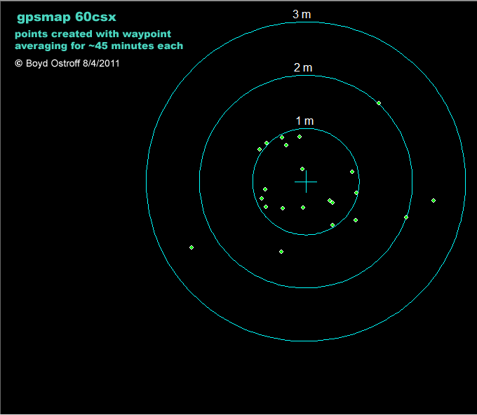
I did this test with my 60csx recently using waypoint averaging while the GPS was attached to a stake in the ground. Each point represents ~2500 individual samples. I find this very impressive for a consumer unit - the majority of the samples fall within a 1 meter radius.

survey01.png


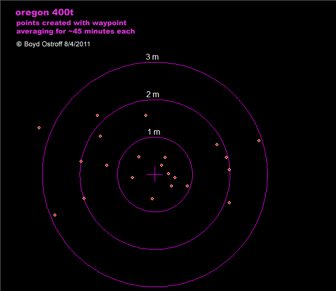
The Oregon didn't do as well in the same test - the points don't show as tight of a pattern.

survey02.png


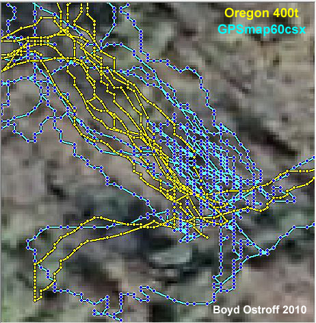
But remember these are tests with the GPS mounted on stake and left there for a long time. In realtime tests of hiking around, the Oregon produced much more repeatable tracks than the 60csx, as discussed here: http://forums.gpsreview.net/viewtopic.php?t=19442

both-04.jpg
 

Gibby

Piney
Apr 4, 2011
1,640
442
Trenton
A walk behind aerator such as a Ryan 28 tines will penetrate around two and half to three inches and a tow behind Ryan 36" weighing five hundred pounds will easily penetrate the length of the tines, which can be five inches. I've been using both for the last three weeks. The plugs look like droppings from geese.
 

Teegate

Administrator
Site Administrator
Sep 17, 2002
25,647
8,251
Boyd,

I always expect too much from my GPS. One day you have to come with AL and I and stone search. You will see that the Oregon fails to work as well as my 60csx when it comes to the arrow pointing in the right directions and the feet counting down especially in dense woods. By that I mean when you are less than lets say 30 feet from the intended location. It seems to work pretty well when I am walking directly towards the location on the first pass, but once I start circling I have a hard time getting back to the original location looking at the GPS. The 60csx will get me back as the feet move steadily downwards and the arrow points properly.

I have been remembering to calibrate both of them each time I use them, so maybe this winter I will have better luck. We shall see.

Guy
 

46er

Piney
Mar 24, 2004
8,837
2,143
Coastal NJ
is it better then a thousand earthworms?how far do they poke into the soil?

A lot less slimy, but faster. Should work really well in sand, but won't leave the goose turds Gibby describes.

Or you could just strap on a pair of these and walk around :D

go1300.jpg
 

Boyd

Administrator
Staff member
Site Administrator
Jul 31, 2004
9,548
2,807
Ben's Branch, Stephen Creek
Have a look at the manufacturer's specs to see how much you should expect. For the PN-60 (couldn't find the PN40) it is 15 meters (49 feet) without WAAS and 3 meters (10 feet) with WAAS. For the Oregon 450 it's 10 meters (33 feet) without WAAS and 3 to 5 meters (10 to 16 feet) with WAAS. The 60csx specs are the same as the Oregon.

It can be hard to wrap your brain around these numbers though. Go to a stake in the ground and mark waypoint "A". It should be within 10 meters of the true location of the stake. Now return to that same spot another day. mark waypoint "B" and it should also be within 10 meters. However "A" could be 10 meters North of the stake and "B" could be 10 meters south. So waypoints A and B could be 20 meters (65 feet) apart and your GPS would be performing up to spec.

Of course, this is a worst case scenario (based on the published specs). I would say real world results are generally much better than this - you will probably get realtime accuracy closer to 5 meters.
 
Top