Getting to Mount / Washington without a mudder vehicle or dirtbike?

TommyP

Explorer
Mar 30, 2022
185
178
Clementon
thomaspluck.substack.com
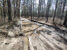
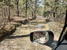
I was trying to follow the Tuckerton stage road using Barbara Solem’s guide, and got a few miles past Penn Swamp on Quaker Bridge Road before a deep rutted mud hole lined with logs and torn up fabric (possibly used for traction by someone else) made me turn back. I made it to Washington Turnpike on Penn Swamp Road without trouble, and helped someone in a Hyundai SUV get through the mud-rutted path around a flooded out portion nearly at the end by the Pike. My Outback does well, but it’s not a lifted offroad truck. I know its limitations, and I measured flood-outs with a hiking pole to test depth and if the ground was soft or solid beneath it. The spots I turned back at were over 10” deep and soft bottom, so bad news for me with only 10” clearance and hybrid tires (not knobby). It was fun trying. I turned around on the Pike and tried going up Mount Road and got another few miles before the paths AROUND the flooded out road were also flooded, soft, and deep. (See photos. First is from Penn Swamp on Quaker Bridge rd, second is from Wash Turnpike on Mount Road)
By then I was hungry and tired and a little disoriented as I had no signal on either Verizon or T-mobile and my iPad was not loading the offline map well.
I am going to try reaching it from Washington-Quaker road from the Washington Turnpike side next time. I thought I had taken it, but I took Mount Road by mistake. Which turns into “Devious Mount Road” and I learned why.
Has anyone driven it recently? I don’t mind walking, but without good spots to pull off the trail I don’t want to park and block it for anyone with a more capable vehicle.
 

Attachments

  • B7B38C2B-71D6-40BF-9D96-3B281D0FC409.jpeg
    B7B38C2B-71D6-40BF-9D96-3B281D0FC409.jpeg
    45.3 KB · Views: 159
  • B2F1DCE3-0039-4218-BBF7-A13CD5FF196F.jpeg
    B2F1DCE3-0039-4218-BBF7-A13CD5FF196F.jpeg
    47.9 KB · Views: 153

TommyP

Explorer
Mar 30, 2022
185
178
Clementon
thomaspluck.substack.com
Thanks all. I need to get a set of paper maps so I’m not stuck when my signal is bad. Which would you recommend? Not expecting the detail of Boyds on paper but I’d feel better having it. If I’d taken Washington-Quaker instead of Mount Road I probably would’ve gotten there.
 

bobpbx

Piney
Staff member
Oct 25, 2002
14,153
4,257
Pines; Bamber area
Thanks all. I need to get a set of paper maps so I’m not stuck when my signal is bad. Which would you recommend? Not expecting the detail of Boyds on paper but I’d feel better having it. If I’d taken Washington-Quaker instead of Mount Road I probably would’ve gotten there.
Don't you have a smart phone? On that, use google map in aerial view. It will tell you exactly where you are unless you have bad service.

Edit: I just realized you said "when my signal is bad". When you are lost, and your signal is bad, walk or drive the roads (dont' leave the roads!) until you have a signal, then you can see where you are.
 

TommyP

Explorer
Mar 30, 2022
185
178
Clementon
thomaspluck.substack.com
I was annoyed that the TomTom built into the car had no detail or road names. I didn't even want their Navigation, but I use it because it's there and doesn't rely on cellular. (TIme to break out the Garmin Nuvi...) I had no bars T-Mobile and one Verizon, and the "offline maps" on the iPad -- which worked fine a week ago -- decided to not work. I was fine, I just took Mount Rd from Washington pike when I wanted to take Washington-Quaker Bridge Rd. It was fun driving it though, and I met some nice people, so no complaints. I am ordering paper maps anyway because as a unix admin I am waiting for all our computers to shut down forever :)
 

martink

New Member
Apr 5, 2009
26
31
57
Hammonton NJ
In the Google Maps app you can download offline maps for any area. I just went into airplane mode to see if it also does satellite view and seems to—most of the pine barrens were working but areas further out toward Delaware (which I haven’t downloaded) were fuzzy.
 
  • Like
Reactions: TommyP

Boyd

Administrator
Staff member
Site Administrator
Jul 31, 2004
9,502
2,765
Ben's Branch, Stephen Creek
I carried paper USGS topo maps with me until I got a GPS sometime around 1998. I'm talking about the "classic" 1:24,000 scale topo's which are also called 7.5 minute topo maps. USGS discontinued these around 2000 and most of them saw very little revision for 30 years before then, so you won't see anything recent. But many people still consider them the "gold standard". I used the final version of these in my 1999 in the Pines map. But you can download scans of the original paper maps directly from the USGS here. Just look for the newest version of each map and note that you want the "HTMC "(Historic Topo Map Collection) and NOT the new "US Topo" which is completely different.


So, in this example, the 1997 1:24000 Jenkins Quadrangle would be what you want. You could print hardcopy or just save the JPEG file on your phone and view it like a photo

Screen Shot 2022-04-17 at 12.29.49 PM.png


USGS used to sell hardcopy of these maps, not sure if they do anymore. The park office at Batsto also used to sell the paper version of these maps, this comes up from time to time and as of a few years ago I believe they still had them. No idea if they still do. But it can be awkward to carry these big maps around. "Back in the day" I used to always have a 1:100,000 map of the Hammonton Quad in my back pocket. This map is much less detailed but was very portable. I had a black and white version that folded up like an automotive map, it was great back then but not very good by today's standards. Still have it, you can see it travelled a lot of miles in my pocket. :)

Screen Shot 2022-04-17 at 12.46.34 PM.png


Couldn't find the black/white version, but here's the color version.


If you zoom my map to level 13, you will also see this same 1:100,000 map
 

Boyd

Administrator
Staff member
Site Administrator
Jul 31, 2004
9,502
2,765
Ben's Branch, Stephen Creek
I wonder if T-mobile isn't your main problem. Admittedly, I've not been to Washington or Mount recently, but don't recall having coverage issues in most of Wharton using AT&T. The T-Mobile map shows a big dead zone in wharton


Screen Shot 2022-04-17 at 1.57.49 PM.png


Don't see anything like this on AT&T's or Verizon's map


TommyP

Explorer
Mar 30, 2022
185
178
Clementon
thomaspluck.substack.com
Thanks all. I think the problem was using offline Google maps on a device without GPS, that is, a wifi iPad. I've also downloaded the entire area to my phone but I think I need to use airplane mode even though it had no signal, because it kept trying to update.
 
  • Like
Reactions: NJCoastal
Jul 12, 2006
1,318
307
Gloucester City, NJ
I wonder if T-mobile isn't your main problem. Admittedly, I've not been to Washington or Mount recently, but don't recall having coverage issues in most of Wharton using AT&T. The T-Mobile map shows a big dead zone in wharton


View attachment 17108

Don't see anything like this on AT&T's or Verizon's map


T-Mobile is horrible in that area. Little to no coverage at all. I don't get the chance to spend the time in the Pines like I used to, but T-Mobile is the worse carrier to have in that area and surrounding area.
 

manumuskin

Piney
Jul 20, 2003
8,552
2,465
59
millville nj
www.youtube.com
I carry a map of the Barrens in my head,Sorry I can't upload it for you. It's just a basic road map but I use a Magellan Triton handheld GPS for finer stuff like stone ;ocations and hard to hit islands in the swamps. Gettin lost ain't that bad.It helps to build that head map a little bit better next time
 

manumuskin

Piney
Jul 20, 2003
8,552
2,465
59
millville nj
www.youtube.com
Thanks. The handheld is a good idea. I didn’t think I’d need one, but they can’t be beat
They don't make Triton anymore.Probably have to go with a garmin but you shouldn't lose recepption.The map you put on it would probably be their aerials? I know garmin severely limits the size of maps other then theirs you can download in order to force you to use their maps which is why I"ll use magellan as long as i can
 
  • Like
Reactions: NJCoastal

Boyd

Administrator
Staff member
Site Administrator
Jul 31, 2004
9,502
2,765
Ben's Branch, Stephen Creek
Al is like the only person in the world who still uses a Triton. :D I actually still have a Triton 1500 but never used it much, very awkward user interface with a combination of buttons that are hard to push and a touchscreen. It has a little toothpick-sized stylus that plugs into a slot. Mine is dead, forgot to remove the batteries and they leaked and messed up the internals. Magellan is a strange story, they were highly regarded and neck to neck with Garmin back in the 90's. My first handheld was a Magellan Meridian Gold that I eventually sold to another member of this site (as of a few years ago, I think she still had it). Here's some fun GPS nostalgia from 2004 for you.

Anyway, Magellan basically blew their early lead in the market and angered lots of people with poor reliability and worse tech support. A big Japanese company bought them and introduced new models that were interesting but not compatible with existing maps from their older devices. Long story short, they are basically gone today with no handhelds and just a couple niche products.

So Garmin is really your only choice. They are rather expensive and for some odd reason they have discontinued their most popular models, the Oregon and the 4" Montana series, replacing it with a huge $700 "brick" with a 5" screen. There are still a variety of models available from them, but when people ask today I have no recommendations. After spending (literally) thousands of dollars on their products for 20 years, I'm done. Some people are slow to accept it, but the dedicated GPS is a dying product category today and Garmin is the only company left, with a de-facto monopoly. I was a moderator at GPSReview.net for many years. Last year that site just went dark one day without warning. The site administrator was even surprised and never found out why the parent company pulled the plug. GPSPassion was the other big site for GPS devices, it also vanished without explanation about a year earlier.

Anyway, the better (more expensive) Garmin models include a liftetime subscription to their "Birdseye" imagery which is aerials from various sources with a resolution around 2-meters (would be equivalent to zoom level 18 in my app). You can purchase Birdseye separately on the devices that don't include it, last I checked it was a $30/year subscription. I suppose that's not such a bad deal, you can keep whatever you downloaded even if you don't renew the subscription but it will only work on the orginal device. All of their maps are copy protected and only work on the original device. If you want to buy a Garmin handheld, look for certified Garmin refurbished devices, they have the same warranty as new with significant savings. Places like GPSCity and TheGPSStore used to be good places to find these in the past, perhaps Amazon? But I no longer follow such things.

But, seriously, if you plan to spend much time in the Pines why not just dump T-Mobile? ;)
 
Last edited:
  • Like
Reactions: NJCoastal

Boyd

Administrator
Staff member
Site Administrator
Jul 31, 2004
9,502
2,765
Ben's Branch, Stephen Creek
Yes, the 66r is interesting, it's a pretty new model though and I have not seen anything to back up their claims of better GPS reception however. Then there's the price.... ;)

But we have been discussing navigation in the pine barrens, not "urban canyons" or "steep country". The old GPS devices used to lose signal under heavy tree cover in the pines, I'm talking about units that are nearly 20 years old such as my StreetPilot 2620 and Magallen Meridian mentioned in the "nostalgia thread" above. I really don't think you will have much problem with that in the pines today with any device from the pat 10 years or so. You may lose some accuracy under dense foliage, but will still know where you are. That has been my experience across many (too many) Garmin GPS devices I've used in the pines anyway.

The eTrex 20 was a popular device that had many happy owners, it was discussed pretty extensively during my many years as a moderator at gpsreview.net. I'd be surprised if it had problems losing signal here in the Pines, although it was a "bottom of the line" handheld. The big complaint I saw about that model was performance using aerial imagery (Birdseye) which was supposed to be very sluggish due to an under-powered processor. But the eTrex series has always been known for superior battery life, not high performance.

Regarding the lack of an "external antenna", that's kind of a funny story IMO. Garmin introduced the external quad-helix antenna on the GPSMap 60 series almost 20 years ago which was followed by the very popular GPSMAP 60csx with the external antenna - I still have mine. These had very good accuracy for their time, which many people attributed to the antenna however the siRFstar II chipset was probably more of a factor there. As time passed, Garmin introduced the GPSMap 62 and 64 series, and now we have the 66. They all shared a similar form factor with the external antenna and pushbuttons.

But in 2022 I think this is really more of a "fashion statement", I have yet to see any evidence that the external antenna does anything to improve accuracy. In fact, Garmin's own GPSMap 70 series Marine devices had the exact same internals as the 60csx but in a waterproof case. They also had the quad helix antenna, but it was inside the case instead of sticking out. AFAIK, this did not affect their accuracy. In the case of the 66 series, I believe that antenna bump is also necessary for the version of the device that has a satellite communicator (inReach Technology).

Now, some older Garmin handhelds had jacks for external antennas. These could improve accuracy by mounting on the roof of your vehicle, or even on your hat while hiking. The same is true for a phone with a bluetooth GPS receiver like the Garmin GLO that I've mentioned. It has a clip I can attach to my hat which gives a better signal because my body isn't blocking its view of the sky.
 

Boyd

Administrator
Staff member
Site Administrator
Jul 31, 2004
9,502
2,765
Ben's Branch, Stephen Creek
Oh, the MGRS grid has been an option on all Garmin handhelds pretty much forever. That has nothing to do with the type of chips, antenna, etc. Here's an ancient webpage listing compatible models... Some of these are over 20 years old, I believe the GPS II+ was introduced in 1998!

http://www.gpsinformation.net/mgrsgps.htm

Geko 101, 201, 301
Foretrex 101 and 201
eTrex Vista Color and Legend Color
The entire GPS 60 family
GPS 76C and 76CS
GPS 72
iQue 3200 and 3600
GPS 276 and 296
GPS 96 and 96C
Quest
eMap
GPS II+
GPS III+
GPS 12 Map
GPS 12, 12XL, 12CX
GPS 76, GPSMAP 76, 76S, 76C, and 76CS
GPSMAP 176, 176C
All eTrex series units
GPS V
GPS III Pilot
GPSMAP 295
Rino (all)
 
  • Like
Reactions: NJCoastal

TommyP

Explorer
Mar 30, 2022
185
178
Clementon
thomaspluck.substack.com
I’ve got a Garmin GPSMap64 and I actually had it with me. I need a better set of maps for it than the default. It didn’t have labels for the roads I was looking at, which is why I went back on Mount Rd (which is better for dirt bikes. I need to compound all the scratches out of the car from the branches) instead of taking Washington-Quaker Bridge, which is supposedly an easier ride.
I just put a 32GB MicroSD card into it to update the standard map (Thanks Garmin, for selling units that can’t fit updates their default map out of the box…) so I can download a Topo map if that’s better.
 
  • Like
Reactions: NJCoastal
Top