Had to travel with the family to Cumberland County today. Instead of going shopping. I decided to kill some time checking out Fries Mill. There were freshly posted WMA signs and a red colored sign in the middle of the tracks right before the train would need to cross the Manumuskim River. Does the train not run through here anymore? While walking along the tracks I noticed they have replaced a lot of ties. There is also a pile of cross tees with insulators from on top of the power poles. My question is, the middle insulator is on a pivot and linkage. Does anyone know the reason for this system? The tag says Electric Power Equipment Corporation, Philadelphia PA. It listed amps as 400 and volts as 23-S?

Glass Insulators
- Thread starter Wick
- Start date
You are using an out of date browser. It may not display this or other websites correctly.
You should upgrade or use an alternative browser.
You should upgrade or use an alternative browser.
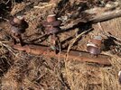
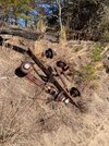
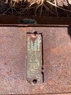

That's a very interesting question I can't answer, but in general I imagine the power equipment is from lines that must have ran along the tracks. Maybe in part servicing the NJ Silica Sand Company adjacent to the Fries Mill site?
Or - on the other hand, perhaps they manufactured electrical equipment specifically for railways, I'm not sure. Not a lot of information out there about this company. Here's an antique cutoff switch with a very similar plaque to what you found:

 www.worthpoint.com
Did you make it out to the chimneys or any of the old foundations? I have not been out here but it's been near the top of my list of places to check out ever since I saw a great video by Part-Time Explorer on YouTube about it:
Or - on the other hand, perhaps they manufactured electrical equipment specifically for railways, I'm not sure. Not a lot of information out there about this company. Here's an antique cutoff switch with a very similar plaque to what you found:
Antique Pull Switch ELPECO Electric Power Equipment Corp Phila Pat.1920 RR RARE | #1819792349
Huge Heavy, Antique Electrical Cut Off Switch for RR, Train or other industry.The switch is marked with an ID tag that reads... ELPECO 'Electric Power Equipment Corporation' Philadelphia, PA. The ID t
www.worthpoint.com
Did you make it out to the chimneys or any of the old foundations? I have not been out here but it's been near the top of my list of places to check out ever since I saw a great video by Part-Time Explorer on YouTube about it:
Last edited:
The tracks are still in use to the other side of Port Cumberland rd technically though I don't believe their hauling sand with them anymore.They use the tracks in manumuskin Preserve as a storing area for cars.Just leave them sit there for weeks or months at a time.The Preserve tried to buy the tracks but the RR refused to sell because it's the only place they can leave such large lines of cars setting.
I did make it the chimneys and foundations. There was one foundation that was perfectly square and in very good condition. There were the ruins of a saw or grist mill too. We hiked through the swamp to a large mound of dirt that was completely out of place. It turned out to be nothing as I could tell. We walked around the entire pit and even found this snake near the back up on the clay cliffs.That's a very interesting question I can't answer, but in general I imagine the power equipment is from lines that must have ran along the tracks. Maybe in part servicing the NJ Silica Sand Company adjacent to the Fries Mill site?
Or - on the other hand, perhaps they manufactured electrical equipment specifically for railways, I'm not sure. Not a lot of information out there about this company. Here's an antique cutoff switch with a very similar plaque to what you found:
Antique Pull Switch ELPECO Electric Power Equipment Corp Phila Pat.1920 RR RARE | #1819792349
Huge Heavy, Antique Electrical Cut Off Switch for RR, Train or other industry.The switch is marked with an ID tag that reads... ELPECO 'Electric Power Equipment Corporation' Philadelphia, PA. The ID t
Did you make it out to the chimneys or any of the old foundations? I have not been out here but it's been near the top of my list of places to check out ever since I saw a great video by Part-Time Explorer on YouTube about it:


pic with the boy in it is the actual Mill foundations. Chimney is at the old Fries Mill Tavern.Was a cabin standing there right into the 1990's.was a piano in it till the 80's.I found a Readers Digest in it from the .Thats back when the cedars shake roof was still good.I did make it the chimneys and foundations. There was one foundation that was perfectly square and in very good condition. There were the ruins of a saw or grist mill too. We hiked through the swamp to a large mound of dirt that was completely out of place. It turned out to be nothing as I could tell. We walked around the entire pit and even found this snake near the back up on the clay cliffs.
View attachment 16955View attachment 16956View attachment 16957View attachment 16958View attachment 16959
pic with the boy in it is the actual Mill foundations. Chimney is at the old Fries Mill Tavern.Was a cabin standing there right into the 1990's.was a piano in it till the 80's.I found a Readers Digest in it from the .Thats back when the cedars shake roof was still good.
I would really love to see photos of the site from back then, if you have any, or know of where any may be found. Such a shame that someone burned the last standing building in the 90s (or so I have read).
I have no photos but was first taken there in the dead of night as a scary trip by Camp Hollybrook counselors in the early 70's regaling us with horror stories of the ghost of Potter whose cabin it was hence the local name of Potters Cabin. It was a cabin in good shape back then though the piano no longer played.I didn't go back till the early 80's.I and the piano was gone.In the early 90's some local yahoo punks set the thing on fire and burnt it to the ground.
Maybe this is a little tangential for this thread, and I think I already know the answer, but I might as well ask anyway since I have your attention, and it is your username, after all ")
Do you happen to know if there is anything left of nearby Manumuskin Station?
At first I was thinking certainly not, as this was probably just a little side platform on the rail line even in its heyday. But then I found a vintage photo purportedly taken inside the station:
 www.mrtheritagesociety.org
So perhaps there was something more than a little platform here after all - an actual station building. So maybe foundations or something remain. Any idea about this?
Do you happen to know if there is anything left of nearby Manumuskin Station?
At first I was thinking certainly not, as this was probably just a little side platform on the rail line even in its heyday. But then I found a vintage photo purportedly taken inside the station:
Maurice River Township Railroads | mrths
www.mrtheritagesociety.org
So perhaps there was something more than a little platform here after all - an actual station building. So maybe foundations or something remain. Any idea about this?
There is no building but there is some kind of large electrical box there that always has a light lit on it and it hums constantly.You can park right next to it.It's maybe eight ft tall if I remember right and four ft across? I can take a pic of it if you like next time I go through there which is quite often. there are often train cars east of the road as well but the mainly store them west of the road often stretching from near the road all the way back past the sand washes which necessitates crawling under them or over the connections when crossing the tracks on any hikes you might be doing. Matter of fact you can see the box on Google Earth Street ViewMaybe this is a little tangential for this thread, and I think I already know the answer, but I might as well ask anyway since I have your attention, and it is your username, after all
Do you happen to know if there is anything left of nearby Manumuskin Station?
At first I was thinking certainly not, as this was probably just a little side platform on the rail line even in its heyday. But then I found a vintage photo purportedly taken inside the station:
Maurice River Township Railroads | mrths
So perhaps there was something more than a little platform here after all - an actual station building. So maybe foundations or something remain. Any idea about this?
That explains all the piles of old bottles buried all over the area. I found some beautiful pieces of broken blue glass. I guess the first foundation by the river was a residence of some sorts?pic with the boy in it is the actual Mill foundations. Chimney is at the old Fries Mill Tavern.Was a cabin standing there right into the 1990's.was a piano in it till the 80's.I found a Readers Digest in it from the .Thats back when the cedars shake roof was still good.
I'd like to check out this mound of dirt on lidar. Would you mind sharing the whereabouts?I did make it the chimneys and foundations. There was one foundation that was perfectly square and in very good condition. There were the ruins of a saw or grist mill too. We hiked through the swamp to a large mound of dirt that was completely out of place. It turned out to be nothing as I could tell. We walked around the entire pit and even found this snake near the back up on the clay cliffs.
View attachment 16955View attachment 16956View attachment 16957View attachment 16958View attachment 16959
I assume it was someones house,I don't have any info on it though.There is a major bottole dump behind the chimney you took a pic of (west of it)That explains all the piles of old bottles buried all over the area. I found some beautiful pieces of broken blue glass. I guess the first foundation by the river was a residence of some sorts?
https://boydsmaps.com/#18.00/39.348809/-74.958864/lidar2021bw/0.00/0.00I'd like to check out this mound of dirt on lidar. Would you mind sharing the whereabouts?
We went into the swamp next to a broken telephone pole. You can see it was next to a drainage pit or part of the creek. Another item of question was by the bridge. You can see it is a raised area. I thought maybe it was a landing of some sorts . There was also a piece of concrete by the water.
It was neat to see the trench that was dug to bring water to the mill. There is a earthen berm that goes across the supply for the mill (not the road) I assume this may have been a dam or where they controlled the water flow.
Last edited:
Another item of question was by the bridge. You can see it is a raised area. I thought maybe it was a landing of some sorts . There was also a piece of concrete by the water.
It appears to have been a beach; I am assuming this used to be part of Camp Hollybrook. Have a look at 1977 Tidelands or 1970 Wetlands maps, both have excellent detail in this location and clearly show the location and context of many buildings and structures nearby.
Here is a dock that was presumably part of the camp, since it is not there in the 30s: https://boydsmaps.com/#19.88/39.349284/-74.958047/njgin1977/-2.16/0.00
So, if that's accurate, I suppose campers used to swim right next to the bridge to Fries Mill? Happy to be corrected on this if it's wrong.
The mound feature you referenced looks like it has a path running to it from the beach. Maybe Manumuskin has memories of what it was.
This whole area is fascinating.
Thanks. Looking at historic aerials, you can see that sometime between 1940 and 1951, the creek was dug out deeper and wider to make a sort of pond (looks like for recreational purposes). The mound you visited were part of the dredge spoils.https://boydsmaps.com/#18.00/39.348809/-74.958864/lidar2021bw/0.00/0.00
We went into the swamp next to a broken telephone pole. You can see it was next to a drainage pit or part of the creek. Another item of question was by the bridge. You can see it is a raised area. I thought maybe it was a landing of some sorts . There was also a piece of concrete by the water.
It was neat to see the trench that was dug to bring water to the mill. There is a earthen berm that goes across the supply for the mill (not the road) I assume this may have been a dam or where they controlled the water flow.
I have never been to that mound but the raised area just east of it is where the saw mill was.You can still see on foundation stone next to the creek.In the 70's camp Hollybrook had a Diving Board attached to it,the bolts I believe are still in it.I was a little guy just learning to swim so i was across the crik on the beach.yep I learned to swim next to the Fires Mill bridgehttps://boydsmaps.com/#18.00/39.348809/-74.958864/lidar2021bw/0.00/0.00
We went into the swamp next to a broken telephone pole. You can see it was next to a drainage pit or part of the creek. Another item of question was by the bridge. You can see it is a raised area. I thought maybe it was a landing of some sorts . There was also a piece of concrete by the water.
It was neat to see the trench that was dug to bring water to the mill. There is a earthen berm that goes across the supply for the mill (not the road) I assume this may have been a dam or where they controlled the water flow.
I don't go back quite that far GabeThanks. Looking at historic aerials, you can see that sometime between 1940 and 1951, the creek was dug out deeper and wider to make a sort of pond (looks like for recreational purposes). The mound you visited were part of the dredge spoils.
Hey I know this area quite well.Anyone interested I can give them quite a tour of Fries Mill and camp Hollybrook complete with memories.Thge land North of the road and east of the creek Belongs to garrison. He is quite the character.He thinks or likes to make you think he owns the whole preserve and if he sees us out there He will approach us and give us the third degree.He has tried that with me and I explained to him just where his property corners were and that we were not inside them and his bravado wasn't impressing me (He used to be a state trooper from what I hear) He then became quite friendly and left us alone.He hates dirt bikers but i was on foot so I don't know what his problem was.Unfortunatley his land is where the girls cabins were.The Chickasaw,Choctaw and Cherokee.Thge boys were Apache which I was,they youngest five though eight,then the Comanche who were nine and ten. and then the Blackfeet who were 11 and 12.Thirteen and above were counselor helpers. I can kick the needles aside and show you the pads.You"llk walk right over em if you don't know where their at.Also the chapel down by the swamp.Pulpit is gone but the RR ties we sat on are still there.I can show you right where my bony little butt sat in 71,72
Hey I know this area quite well.Anyone interested I can give them quite a tour of Fries Mill and camp Hollybrook complete with memories.Thge land North of the road and east of the creek Belongs to garrison. He is quite the character.He thinks or likes to make you think he owns the whole preserve and if he sees us out there He will approach us and give us the third degree.He has tried that with me and I explained to him just where his property corners were and that we were not inside them and his bravado wasn't impressing me (He used to be a state trooper from what I hear) He then became quite friendly and left us alone.He hates dirt bikers but i was on foot so I don't know what his problem was.Unfortunatley his land is where the girls cabins were.The Chickasaw,Choctaw and Cherokee.Thge boys were Apache which I was,they youngest five though eight,then the Comanche who were nine and ten. and then the Blackfeet who were 11 and 12.Thirteen and above were counselor helpers. I can kick the needles aside and show you the pads.You"llk walk right over em if you don't know where their at.Also the chapel down by the swamp.Pulpit is gone but the RR ties we sat on are still there.I can show you right where my bony little butt sat in 71,72
That would be amazing, I know we are complete strangers but I'd genuinely be interested in doing that sometime, if you wanted to meet. It would be really cool to get a group together and coordinate if others here are interested in that sort of thing.
problem is I work shift work with rotating days off.Right now I"m off thur and fri and I back up a day every three weeks.if people want to go that have weekends off like normal folks I won't have those off again till probably late may or june.It's fifteen minutes from my house so I can make several trips if a few can go one day and a few another day but I"m on a strict point system so I don't take off unless absolutely necessary.They'd fire the plant manager if he pointed out.Matter of face they just did fire him but it wasn't pointsThat would be amazing, I know we are complete strangers but I'd genuinely be interested in doing that sometime, if you wanted to meet. It would be really cool to get a group together and coordinate if others here are interested in that sort of thing.