Google maps getting dumbed down even more?

Boyd

Administrator
Staff member
Site Administrator
Jul 31, 2004
9,631
2,851
Ben's Branch, Stephen Creek
Have you noticed a lack of road labels on Google maps recently? I don't use them all that often, but am working on my own streetmaps of the Northeast US right now and wanted to compare some things. Here's an example of the problem: there are some pretty major roads here.... what are they? No names and no icons showing route numbers (like the red, white and blue interstate highway shields).

https://www.google.com/maps/@41.3156125,-74.1204245,14z?entry=ttu

google.png


And this isn't just a cherry-picked screenshot, I can scroll around and zoom in and out all I want and no labels ever appear. Maybe there's a preference setting I don't know about? Or maybe I'm weird for wanting to know road names? :ninja: Guessing that Google decided most people don't care and only want to follow directions (turn right in 1.2 miles, etc). I know that's what my kids do, they never even look at the screen, just listen to the directions.

For comparison, Bing Maps shows everything, along with lots of intrusive sponsored POI's :D

https://www.bing.com/maps/?cp=41.307847~-74.149845&lvl=14.2

bing.png


Apple Maps has them too, but their color choices make it hard to see some of the roads

apple.png


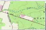
OpenTopoMap doesn't score very high with streetnames either, they don't even show interstate icons.

https://boydsmaps.com/#14.00/41.307514/-74.127049/usopentopo/0.00/0.00

opentopo.png


And while I don't like their overall style, at least the USGS has basic road info

https://boydsmaps.com/#14.00/41.307514/-74.127049/ustopo2023/0.00/0.00

usgs.png


Lots of work left to do on my version, but it will have plenty of road information. :) Creating the route icons and exit numbers is a big job, I am doing it "from scratch" for the most part. But they're something I find essential for the way I use maps.

boyd.png
 

Boyd

Administrator
Staff member
Site Administrator
Jul 31, 2004
9,631
2,851
Ben's Branch, Stephen Creek
OK, that's weird. Now it shows the names. :ninja: Wonder why they weren't showing before? That's why I posted, I thought it was something new because I'm sure I've seen names (like this) in the past.

Screen Shot 2024-06-29 at 12.59.11 PM.png
 
Last edited:

Boyd

Administrator
Staff member
Site Administrator
Jul 31, 2004
9,631
2,851
Ben's Branch, Stephen Creek
This is probably it (evidently a common problem, found it with a Google search). If you have the "Transit" or "Biking" layer selected, route numbers don't show. I guess it was defaulting to that for some reason (screenshot looks more like the Biking layer). That's a new one for me. :clint:

Screen Shot 2024-06-29 at 1.02.34 PM.png
 
  • Like
Reactions: Teegate

Boyd

Administrator
Staff member
Site Administrator
Jul 31, 2004
9,631
2,851
Ben's Branch, Stephen Creek
That doesn't bother me nearly as much as what the USGS did to the 7.5 minute quarter-quads several years ago

I am not impressed with the new US Topo maps either, to put it nicely. But, according to the USGS, they stopped making legacy 24k maps in 1992 and stopped revising them in 2006. I can understand how that only seems like "several years" when you're driving a 25 year old truck though. :D (sorry, couldn't resist)

This is what the USGS said when they launched the US Topo program (the new maps)

"Traditional national mapping programs gathered data from primary sources, including direct field observation. Such maps were compiled, drawn, and edited by hand. In the United States, the era of traditional topographic mapping lasted from about 1880 to about 1990, and was primarily the responsibility of the U.S. Geological Survey (USGS). By today's standards these traditional methods were very expensive, and USGS no longer has either mission or funding to make maps this way."

I think the "funding" part is probably the key. But the "mission" aspect is interesting, according to their site, core science systems (mapping) is only one of five mission areas.

I don't have any gripes with the USGS, they produce an unbelievable amount of data and make it available for free to everyone. Most other countries don't have anything like this. A few years ago they started moving it all to AWS servers which is a huge upgrade (as much as I dislike Amazon). It's now really fast and easy to download a wealth of geodata. I think you could make a good argument that all of this new, accessible technology and the secondary products that are produced from it provide more value to all of us than the paper topo maps did in their era.

I'm building my new Northeast US street map from current US Topo data, was originally going to use OpenStreetMap but after some in-depth study I liked the USGS data better. They seem to be steadily improving the new topo maps but aren't quite putting all the pieces together. Maybe they just no longer have people who remember what "real" topo maps look like and are striving for more of a Google maps style? Don't know, but think they could make new maps that are closer in style to the legacy topo's using available resources, if they wanted to.
 

RednekF350

Piney
Feb 20, 2004
4,981
3,182
Pestletown, N.J.
27 year old truck. Get it right! :)
My issue with the maps is not only the lack of physical detail, but they also thinned out the contour labeling so much that you get lost trying to follow a contour to see what it is. We used to use snippets of USGS maps for our key maps in various land use development applications and we would also include such maps in reports for agencies like NJDEP which required a plotting of a property on a USGS Quarter-quad. Now, that snippet rarely includes a contour label.

Examples attached. New vs old. The Myers Auto salvage yard area. Old Ham is the good old USGS map.
 

Attachments

  • old hamScreenshot 2024-06-30 142213.png
    old hamScreenshot 2024-06-30 142213.png
    2 MB · Views: 14
  • hamScreenshot 2024-06-30 141742.png
    hamScreenshot 2024-06-30 141742.png
    554.4 KB · Views: 14
  • Like
Reactions: Boyd

RednekF350

Piney
Feb 20, 2004
4,981
3,182
Pestletown, N.J.
I purposely zoomed way out on the newer map to show the dearth of contour labeling.
The old maps always gave you road intersection spot elevations too.
I’m a dinosaur and I like it !!
 
Last edited:
  • Like
Reactions: Boyd

Boyd

Administrator
Staff member
Site Administrator
Jul 31, 2004
9,631
2,851
Ben's Branch, Stephen Creek
I agree that the readability of the new topo maps is poor. But contours lines are a lousy source of elevation data in today's world. They are just approximations of elevation based on estimates. The elevation data used to create the contours on the legacy 24k maps is very low resolution by current standards. But, at least here in the Pines, we have very high resolution LIDAR DEM that can be easily downloaded. Here's an example in the vicinity of your screenshot.

lidar.png


It only takes a few clicks to generate contour lines if you need them, and they won't look anything like what you find on a topo map. Here are 1-foot interval contours

full_contours.png


Here's a close-up of the gravel pit in the purple rectangle to show the amount of detail

contours.png


For more casual use, you can get high resolution data from my site.

https://boydsmaps.com/#17.00/39.715170/-74.814832/midatlidar/0.00/0.00

And the elevation is displayed on any map in realtime as you drag it around. If you want the elevations of intersections, just position the crosshairs on them and click. That will create a waypoint which includes the LIDAR elevation. These can be exported for use in other software, including Google and Garmin. You can get even more detail in my terrain viewer, just click the blue cube at any location on the map.

https://boydsmaps.com/terra/#39.715...0/0/0/1000/600/-1000/45/4/2d/shader40/0/0/z17

terra.png


Anyway, I certainly love the old style topo maps which is why I put about 7,500 of them online for anyone to view. I also spent hundreds of hours last year making a new map of the Pines in the style of the old topo's. But it's not 1992 anymore, and there are much better sources for just about all of the data on those old maps, and it's in digital form which makes it easier to use and share.

I was recently remembering when I got really interested in the 24k topo maps. It was my freshman year in college in 1967 and I enjoyed spending time at the library just looking at stuff that interested me. So, I spent a lot of time in the map room where they had big file drawers with topo maps from many places. But think of the amount of space required to store all of these. I have a ream (500 sheets) of paper here and it's 2" thick. I'm pretty sure that the paper from those old topo maps was at least twice as thick as this cheap printer paper. Just for the sake of argument, let's say a stack of 100 paper topo maps would be one inch high. The 7500 topo's on my site would be a stack over 6 feet high, would hate to guess how much that would weigh!

The continental US is something like 40,000 quads. I doubt that many libraries would have had that many available. And think of the nightmare keeping them organized! It was always a challenge finding what you wanted on those drawers back then, with people constantly rummaging through them.

I think we've come a long way since then, and we have to think of geodata in different terms today. I'm all for honoring the accomplishments of the past, but we shouldn't let it hold us back today.
 
Last edited:
  • Like
Reactions: RednekF350

RednekF350

Piney
Feb 20, 2004
4,981
3,182
Pestletown, N.J.
You’re missing my point somewhat, Boyd.
Placing a simple key map on a site plan in the old USGS map format was perfect and showed just enough information for the purpose at hand. It didn’t have to be screaming with detail, it just needed to have an informative image and be just a little bit accurate.
My coworkers and I use your mapping programs all the time at work especially the LIDAR. I’m using it probably 3 to 4 times a week for a wide range of purposes.
 
  • Like
Reactions: Boyd

RednekF350

Piney
Feb 20, 2004
4,981
3,182
Pestletown, N.J.
Oh, as for my 27 year-old 1997 F-350, I put her (the truck) to work yesterday along with my wife. This is my wife tooling up 73 yesterday with my baby, a 1997 F-350 to help me do a final cleanout of my sister's house with me. Photo taken from my 22 year-old 2002 F-350 diesel. Hard to find a woman today to drive a 5-speed manual and willing to drive a truck with no air on a 90 degree day.

I ordered the red truck new in 1997 as an XL with no air conditioning and a 5-speed manual with a creeper. My option list consisted of a limited slip 4.10 axle ratio and an AM/FM radio. Solid axle came stock in the front with a Dana 60, and a Ford Sterling 10.5" in the rear. It has the standard 351 gasser, a reliable motor that Ford started making in 1969. Only 130,000 miles on the clock and it's as bombproof as they get. Analog gauges and no dumb ass video screens or back-up cameras in my dash and no audible warnings of any kind. Thankfully, Ford still allows you to disarm the annoying seat belt warning chimes. I have disabled them in every Ford I have ever owned, including my wifes 2017 Explorer. After all, it is still 'Merica!
:)

IMG_6314.jpg
IMG_6316.jpg
 

GermanG

Piney
Apr 2, 2005
1,127
454
Little Egg Harbor
Very nice truck but I went in the other, more minimalist direction, for every day driving with my 79 F-100, with a 300 inline and a 3-on-the-tree tranny. I started in 1st, accelerated in 2nd, and drove in 3rd. I miss it. I spend way too much time moving through the six gears now in my Crosstrek. The Ford was far from heavy duty but regularly carried a full bed of firewood with no problem and did everything else I asked of it within reason. I didn't get a 350 until later on when my tree service necessitated it. But I'd give anything to once again have a truck with a dashboard looking closer to that of a Model T than of the space shuttle. Oh yeah, it was also red! ;)
 

Boyd

Administrator
Staff member
Site Administrator
Jul 31, 2004
9,631
2,851
Ben's Branch, Stephen Creek
The space shuttle first flew in 1981 (and was retired in 2011), maybe not so different in terms of technology from your old truck. :D Although I understand your point, it's interesting you would pick that as an example of current technology. New vehicles make extensive use of touchscreens, which weren't used on a spacecraft until 2020.
 
Last edited:

RednekF350

Piney
Feb 20, 2004
4,981
3,182
Pestletown, N.J.
Very nice truck but I went in the other, more minimalist direction, for every day driving with my 79 F-100, with a 300 inline and a 3-on-the-tree tranny. I started in 1st, accelerated in 2nd, and drove in 3rd. I miss it. I spend way too much time moving through the six gears now in my Crosstrek. The Ford was far from heavy duty but regularly carried a full bed of firewood with no problem and did everything else I asked of it within reason. I didn't get a 350 until later on when my tree service necessitated it. But I'd give anything to once again have a truck with a dashboard looking closer to that of a Model T than of the space shuttle. Oh yeah, it was also red! ;)
German,
I had an '82 F-150 with the 300-inline with a Ford 4-speed manual with overdrive. I sold it to my father-in-law in 1987 and he ran it until he died. We sold it to a local landscaper who ran it for years.

My first heavy duty truck was an '87 F-250, also with 300-inline. That truck had the best trans ever made, the Borg-Warner T-18. Cast iron housing, unsynchronized creeper and a reverse shift gate so deep that the shifter would almost rest on the seat. They were made from 1965 until 1991 and you can still order them from custom rebuilders. I sold that truck to the same landscaper with 170,000 on it.

My '02 7.3 just turned 293,000 miles and I know for a fact that I won't be alive long enough to see it turn 1,000,000 miles which is what that motor is known for. It took me 22 years to put that mileage on so it will take me at least 53 more years to hit a million miles. The body, on the other hand, won't be with me much past this Christmas. :)
 
  • Like
Reactions: Boyd
Top