
GPS recommendations
- Thread starter sgtdave4321
- Start date
You are using an out of date browser. It may not display this or other websites correctly.
You should upgrade or use an alternative browser.
You should upgrade or use an alternative browser.
Update February 2022: downloadable maps are no longer available, but you can access hundreds of maps in the boydsmaps web app
Have spent the past few days editing the tutorial for my big map and realized that it's quite complicated and the 12 gigabyte download will scare many people away. So I made a much smaller map that anyone could quickly install to "get their feet wet" using a phone as a GPS. It works on Android and iOS with the Galileo app, which has a free 5 day trial. After 5 days you can either look at ads or purchase the Pro version for three bucks. You can also use the map in Backcountry Navigator on Android and Map Plus on the iPhone.
Have a look at the tutorial and see if you want to give it a try. You can be up and running with my map in Galileo in just a few minutes.
boydsmaps.com/download/Boyds%20Map%20of%20the%20Pines%20HD%20Lite.pdf
You'll see a link in the documentation to download a larger 2.4GB map that covers the core of the Pines and installs the same easy way. My big 12GB HD Map of the Pines should also be ready soon. Will start another thread when it is.")
Have spent the past few days editing the tutorial for my big map and realized that it's quite complicated and the 12 gigabyte download will scare many people away. So I made a much smaller map that anyone could quickly install to "get their feet wet" using a phone as a GPS. It works on Android and iOS with the Galileo app, which has a free 5 day trial. After 5 days you can either look at ads or purchase the Pro version for three bucks. You can also use the map in Backcountry Navigator on Android and Map Plus on the iPhone.
Have a look at the tutorial and see if you want to give it a try. You can be up and running with my map in Galileo in just a few minutes.
You'll see a link in the documentation to download a larger 2.4GB map that covers the core of the Pines and installs the same easy way. My big 12GB HD Map of the Pines should also be ready soon. Will start another thread when it is.
Last edited:
My larger "Core of the Pines" map is now ready for download. Here's the coverage area compared with the "Lite" map
.

Let me know if everything works and if you find anything confusing in the tutorial. These maps may be compatible with additional Android or iOS app as well. Let me know if you find any, they will need to support sqlitedb format offline maps to be compatible.
.
Let me know if everything works and if you find anything confusing in the tutorial. These maps may be compatible with additional Android or iOS app as well. Let me know if you find any, they will need to support sqlitedb format offline maps to be compatible.
Last edited:


I hiked the last leg of my hike today in the dark from Quaker Bridge to Carranza using the Gaia app on my iPhone. I was going to upgrade my 10 year old Garmin handheld GPS but the apps I have on my phone work so well I couldn't justify spending $200-$500 for a backup handheld device.
I have tried most of the GPS apps available in android and IOS, and the my first choice is Gaia, my runner up is MiliGPS. Gaia is already loaded with the Batona Trail, so I can see exactly where I am on the trail, how far I am from my destination, and I can see it in multiple viewing options. In two hours and fifteen minutes of continuous use of the Gaia app, it only drained 8% of my battery power, which is not bad for a GPS app with a continuous position display.
I have tried most of the GPS apps available in android and IOS, and the my first choice is Gaia, my runner up is MiliGPS. Gaia is already loaded with the Batona Trail, so I can see exactly where I am on the trail, how far I am from my destination, and I can see it in multiple viewing options. In two hours and fifteen minutes of continuous use of the Gaia app, it only drained 8% of my battery power, which is not bad for a GPS app with a continuous position display.
Thanks for all the hard work. I'll have to download the package and give it a try. Out of curiosity is there a reason this wasn't done to just overlay an existing Google Maps app, rather than requiring yet another mapping app to get installed on a phone?
I'm sure there's some technical or licensing issue, but figured I'd ask.
I'm sure there's some technical or licensing issue, but figured I'd ask.
You can create overlays that work in Google Earth on your computer, but that feature is not available in their smartphone app. As to why... I guess you would need to ask Google. I suspect they just don't see any motivation to support something like this. Most people wouldn't be interested and Google's real goal is to track wherever you go and whatever you click on, so they can sell the info to advertisers. ")
Just to prove I haven't completely forsaken you, here's a Garmin version of my HD map that covers most of Wharton. You can read the documentation here: boydsmaps.com/download/Boyds HD Map of Wharton for Garmin.pdf
Download the full package here, it's about 180mb:boydsmaps.com/download/boydmapWhartonHD.zip
As you can see, there are severe limitations on how large a map Garmin allows you to install on the GPS. For more flexibility, you can install my full HD Map on your computer when it's available. You can then use Mobile Atlas Creator to export any portion you choose for your GPS.
You can read the documentation here: Download the full package here, it's about 180mb:
As you can see, there are severe limitations on how large a map Garmin allows you to install on the GPS. For more flexibility, you can install my full HD Map on your computer when it's available. You can then use Mobile Atlas Creator to export any portion you choose for your GPS.
Last edited:
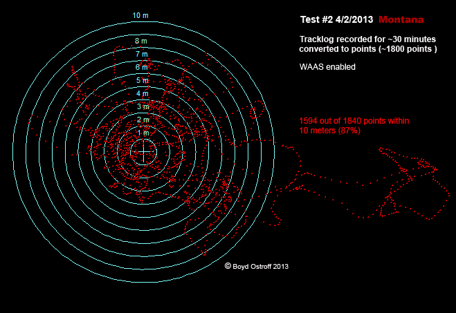
I did some testing back in 2013 and the 60csx held its own quite well. In these tests, the GPS was stationary with a good view of the sky and I just let it record one point per second for about a half hour, resulting in ~1800 points. The center of the bullseye is the actual location and the rings are spaced one meter apart.
With the 60csx, 94% of the points were within 10 meters and they were clustered pretty tightly (although off-center). There are "tails" at 5, 7 and 10 o'clock though where it wandered pretty far.

The Montana 600 did not show such a tight pattern of points, it was more like a shotgun blast and some points wandered very far from the target.. But if you averaged them all, you would be very close to the center of the bullseye. On the surface, it looks like the Montana is not as accurate, but if you were recording points with waypoint averaging, you might get better results than the 60csx. Still, I find this rather disappointing for such an expensive device. Statistically, 87% of the points were within 10 meters which isn't a lot different from the 60csx.
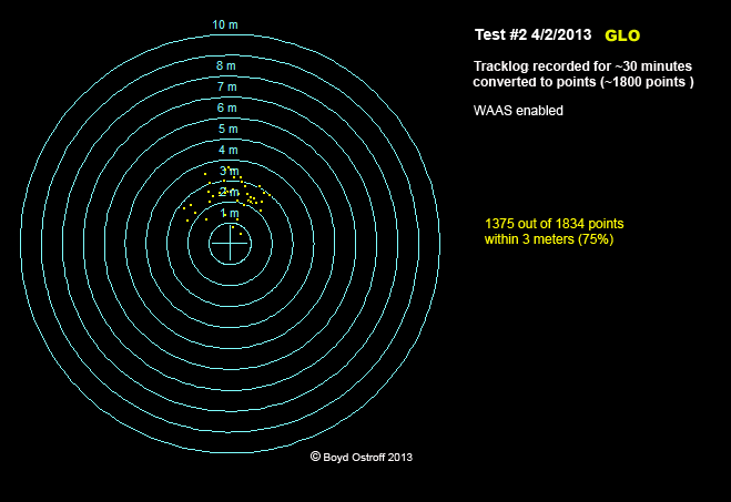
But now look at the GLO, Garmin's bluetooth GPS receiver that you use with a smartphone. It receives additional signals from the GLONASS satellites and it also records position fixes faster than Garmin's handhelds. Believe it or not, there are actually the same number of points in this image, but they are all right on top of each other. 100% of these points were within 10 meters and 75% were within 3 meters of the target. I found this very impressive for a $100 device. Garmin's new models (like the Oregon 700, Montana 700 and GPSMap 64) also have GLONASS receivers but I have not tested any. I suspect they would also beat the Montana 600.
But aside from accuracy, the 60csx really shows its age in terms of map rendering. It's really slow compared to newer devices and is not compatible with the new map formats (such as the Garmin files I posted above). Not compatible with aerial imagery such as Garmin Birdseye. The tiny screen only supports 256 colors and there's an old bug that causes lowercase text in maps to be garbled. Screen is very readable in daylight without the backlight, it's really the champ at that. But in a situation where you need the backlight, it's horrible. Very dim.
So if your main interest is accuracy in recording waypoints and tracks, I think the 60csx holds it own. But otherwise it's very out of date. I still have mine and plan to keep it though. There's just something cool about it, feels rugged and well designed. I gather they sell for ridiculous prices on eBay, so they are still popular.
With the 60csx, 94% of the points were within 10 meters and they were clustered pretty tightly (although off-center). There are "tails" at 5, 7 and 10 o'clock though where it wandered pretty far.
The Montana 600 did not show such a tight pattern of points, it was more like a shotgun blast and some points wandered very far from the target.. But if you averaged them all, you would be very close to the center of the bullseye. On the surface, it looks like the Montana is not as accurate, but if you were recording points with waypoint averaging, you might get better results than the 60csx. Still, I find this rather disappointing for such an expensive device. Statistically, 87% of the points were within 10 meters which isn't a lot different from the 60csx.
But now look at the GLO, Garmin's bluetooth GPS receiver that you use with a smartphone. It receives additional signals from the GLONASS satellites and it also records position fixes faster than Garmin's handhelds. Believe it or not, there are actually the same number of points in this image, but they are all right on top of each other. 100% of these points were within 10 meters and 75% were within 3 meters of the target. I found this very impressive for a $100 device. Garmin's new models (like the Oregon 700, Montana 700 and GPSMap 64) also have GLONASS receivers but I have not tested any. I suspect they would also beat the Montana 600.
But aside from accuracy, the 60csx really shows its age in terms of map rendering. It's really slow compared to newer devices and is not compatible with the new map formats (such as the Garmin files I posted above). Not compatible with aerial imagery such as Garmin Birdseye. The tiny screen only supports 256 colors and there's an old bug that causes lowercase text in maps to be garbled. Screen is very readable in daylight without the backlight, it's really the champ at that. But in a situation where you need the backlight, it's horrible. Very dim.
So if your main interest is accuracy in recording waypoints and tracks, I think the 60csx holds it own. But otherwise it's very out of date. I still have mine and plan to keep it though. There's just something cool about it, feels rugged and well designed. I gather they sell for ridiculous prices on eBay, so they are still popular.
I can't get my 60CSX to connect to my current computer and because of that I still have my older computer sitting here. If I get rid of it I would have to use my wife's Windows laptop to connect. Boyd, if you know about a driver for 10.XX let me know.
Guy, it's been a long time since I've used the 60csx on a Mac. I mostly used Windows with my Garmin devices, in the past it worked better and I actually preferred Mapsource to Basecamp (especially for older models).
Of course you can transfer data to a memory card by using an external USB reader reader or built-in slot if your Mac has one. But I'm assuming you're talking about sending/receiving waypoints, which uses Garmin's proprietary protocol. IIRC, the last time I tried doing this on Windows, Basecamp didn't work. I ended up using Mapsource and that was OK. Never took any time to troubleshoot since I just don't use the 60csx anymore.
Of course you can transfer data to a memory card by using an external USB reader reader or built-in slot if your Mac has one. But I'm assuming you're talking about sending/receiving waypoints, which uses Garmin's proprietary protocol. IIRC, the last time I tried doing this on Windows, Basecamp didn't work. I ended up using Mapsource and that was OK. Never took any time to troubleshoot since I just don't use the 60csx anymore.
I can't get my 60CSX to connect to my current computer and because of that I still have my older computer sitting here. If I get rid of it I would have to use my wife's Windows laptop to connect.
Can you emulate Windows on your system to work with the CSX?
I installed the newest version of Garmin's Bluechart in my 60CSX last summer because I lost my original 60CSX a few years ago and my Bluechart was in it. 
Several website FAQ responses said it would work in my unit so I ordered it. That same day I had sent an email to Garmin asking that same question. It took about two days for that response and my chip was already on the way at that point. Garmin said it would not work in my unit.
As it turns out, Garmin was wrong. It does work but I obviously can't get all the 3D features of a modern Bluechart on my unit but I really don't need any of that anyway as my dash mounted 740s has all of that. I use the 60CSX on my boat when I am away from the helm and I use it on other people's boats when I feel that they are electronically challenged and we are not hitting the structures just right or if they seem to not know where they are going.
Everything old is new again.... There was a recent Wall St. Journal editorial warning of the vulnerability of GPS to EMP and urging congress to bring back the Loran system.
"Fifteen of the “18 Critical Infrastructure and Key Resource sectors” in the U.S. are GPS-reliant, according to the Department of Homeland Security.
_________
Anything that requires precise timing would be affected because GPS satellites serve as global timekeepers. The loss of clock synchronization across the world would cause the internet to stall and financial transactions to cease.
_________
Congress is considering a bill, the Department of Homeland Security Authorization Act, that would revive and enhance Loran into a highly reliable, ground-based backup system."
https://www.wsj.com/articles/if-gps-failed-wed-be-more-than-lost-1511730287
(article is only available for subscribers, but you should be able to read it by typing "wall st journal gps lost" into a Google search)
Everything old is new again.... There was a recent Wall St. Journal editorial warning of the vulnerability of GPS to EMP and urging congress to bring back the Loran system.
Just in case...
www.loran-history.info/Loran-C/Jansky _ Bailey 1962.pdf