Great shot of the red-bellied cooter in that first pic Toothy Critter! Also, regarding mullein, the dried stalk makes a good hand drill for friction fire.

You are using an out of date browser. It may not display this or other websites correctly.
You should upgrade or use an alternative browser.
You should upgrade or use an alternative browser.

T
Toothy Critter
Guest

Colliers Mill WMA
Speaking of that area. Do you know who owns this preserve? I think it may be Plumsted Township. Have you ever been in there?
T
Toothy Critter
Guest
I believe that is on the Joint Milatary base property. I fished there 20 years ago when they allocated permits to fish on Ft Dix, but they have since ended that to private citizens. . There were a half dozen lakes that were fishable, each with a specific dominant species. Nearby Brindle Lake, which is just southwest of the area you highlighted was especially targeted and I miss that one in particular. I will not say for certain that Jumping Brook is on Base property but I am almost sure of it as far as I can recollect. Although one map shows it just outside the base but with no access to my knowledge.
Last edited by a moderator:
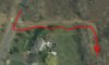
Not part of the base. See first photo below, and entrance from Cranberry Canners Road. See the base boundary in blue in second photo.


T
Toothy Critter
Guest
Nice info.. I will check this out soon. And make some calls. Thanks. According to maps, the tank itself has had water continuously.
It is part of New Egypt, Plumstead Twnship; a good birding spot. There is a ROW thru, I believe, private property.
https://en.calameo.com/read/00019277085d00ef1f78c
https://en.calameo.com/read/00019277085d00ef1f78c
I believe that is on the Joint Milatary base property.
FWIW, I have included the Joint Base boundaries on my Map of the Pines (shown as a heavy dashed line). Could not find an official source for the boundary, so I used tax parcel data. There could be some errors, so caveat emptor, but I think it's reasonably accurate. Just don't blame me if you end up in the brig.

https://online.boydsmaps.com/#13/40.0083/-74.4651/pinesHD-x
Also see "Parcels in the Pines" for ownership info, but again "caveat emptor"
https://online.boydsmaps.com/#14/40.0079/-74.4772/parcels-x
Nice info.. I will check this out soon. And make some calls. Thanks. According to maps, the tank itself has had water continuously.
The right of way is so close to a house that I"ll bet it's little used because people are hesitant. It at first appears part of their yard.
Yes, I've been on that road several times botanizing. That google mobile went through the gate that is usually closed. There is a gate right after that reservoir close to the road heading east.
T
Toothy Critter
Guest
Yes, I've been on that road several times botanizing. That google mobile went through the gate that is usually closed. There is a gate right after that reservoir close to the road heading east.
So you turned left onto the dirt road from Cranberry Growers Road and was able to drive exactly how far in? You say there is a gate right past that reservoir. Just to clarify, there is technically only one "reservoir" which is actually called a "tank". That is the waterbody to the upper northeast of the preserve. The rest of the waterbodies are just abandoned bogs. A tank is the storage water so when they need to flood the bogs. Can we drive anywhere near this tank (reservoir)? Only reason is I am consumed with fishing some of the most remote ponds in the State. I apparently overlooked this by assuming it was, like nearby Brindle, on Base property and thus off limits. Thanks for your input.
I looked at Boyd's Lidar map. If these roads are drivable, this might be the best route to the tank.
https://maps.njpinebarrens.com/#lat=40.04191961342056&lng=-74.48604107926604&z=16&type=lidar&gpx=
EDIT: Never mind, it looks like the road is inside the base boundary.
https://maps.njpinebarrens.com/#lat=40.04191961342056&lng=-74.48604107926604&z=16&type=lidar&gpx=
EDIT: Never mind, it looks like the road is inside the base boundary.
T
Toothy Critter
Guest

")
So you turned left onto the dirt road from Cranberry Growers Road and was able to drive exactly how far in? You say there is a gate right past that reservoir. Just to clarify, there is technically only one "reservoir" which is actually called a "tank". That is the waterbody to the upper northeast of the preserve. The rest of the waterbodies are just abandoned bogs. A tank is the storage water so when they need to flood the bogs. Can we drive anywhere near this tank (reservoir)? Only reason is I am consumed with fishing some of the most remote ponds in the State. I apparently overlooked this by assuming it was, like nearby Brindle, on Base property and thus off limits. Thanks for your input.
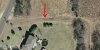
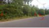
I"m sorry, I did not see this post until now Critter. No, I did not try to drive in from Growers road until last night, and something is wrong. I found 2 signs that indicate there is an easement, but they don't match what I thought was the way in. Look at the 2 aerials below, one ifs from the state tax map and it seems to indicate an easement right next to the private property. Then, look at the 2007 aerial from boyd's maps site and you can clearly see there was a way in at one time. Now I find that this is ambiguous because the homeowner apparently put grass there and made it look like there is no way in. But, I find two easement signs on the north side (left side looking in) of the supposed easement road, so I"m wonder just what is going on. Something is fishy here, so I plan to go to the township. There needs to be a way in.
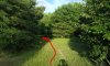
That telephone pole is key to this story, it has not moved. See my photo from last night looking down the supposed road from the hard road. The telephone pole is on my right. As you look down the road, it is covered in grass and made to look like a lawn.
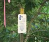
But there are 2 easement signs immediately north of the road. First I have a photo of a sign, and then a backed up shot showing where they are placed. Oddly, the one on the right has disturbed dirt around it (if you get my meaning, something may have moved). I'm not accusing anyone just yet, maybe some money legally changed hands.
Attachments
A lot depends on the type of easement. If it were voluntary, and the Wetlands Program was, the landowner controls access and has the right to close it.
But, this is their property from parcels.com. Something is rotten in Denmark (or Plumsted).
