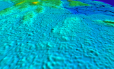
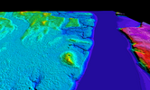
I have been doing some searching on Lidar for old home sites and tar kiln in my area and have found something near Estelle Manor Park off of South river. I spotted this last year and have tried making multiple attempts to get to the area with no luck. Tried getting to it from different directions and it is really thick. There looks to be a road going to what looks like a foundation or wall of some sort from lidar. Aerials doesn't really show much. Any help or info would be appreciated https://boydsmaps.com/#17.30/39.418938/-74.721568/midatlidar/0.00/0.00
Help identifying what i see on Lidar
- Thread starter Dirtrider2
- Start date
You are using an out of date browser. It may not display this or other websites correctly.
You should upgrade or use an alternative browser.
You should upgrade or use an alternative browser.
Not familiar with that site although I've been all over the Belco ruins just West of there and have included them on recent maps.
I see that line (wall?) to the left of the link you posted but not sure what it is, maybe the the remains of an old road with a ditch that was excavated? You can play around with the lighting and other parameters in the terrain viewer and see if that helps.
https://boydsmaps.com/terra/#39.418...0/4/0/1239/704/-1000/45/4/2d/shader40/0/0/z17
Just looking some more, I see that the Vermeule map shows some roads in that area that don't appear on other maps.
https://boydsmaps.com/#15.00/39.418938/-74.721568/vermeule/0.00/0.00
https://boydsmaps.com/#15.00/39.418938/-74.721568/vermeule/0.00/0.00
It's hard to believe it today, but this stretch of land was probably used by the eighteenth century as horse and cow pasture—savannah, as in Demitroff 2024 (Soggy Ground). Just to the northeast Dowers had a ferry to Tompsontown that ran through at least the Civil War. This connected the Lower Cohansey trail to the Long-a-Coming trail. Due south, across Tows Island Creek, lies Tow Island.
My guess is that "tow" refers to bundle of untwisted natural fibers, perhaps a place in the eighteenth century to grow flax like around Absecon. That might help explain the other Tow Islands around South Jersey. To the east, across the Great Egg Harbor River were extensive wharves and fisheries going back to the late seventeenth century.
Barns and fish-processing sites were present on the west bank of the Great Egg Harbor River, but were mostly atop Pleistocene dunes or protodunes adjacent to a navigable waterway. Ruddick or Ruddock Townsend owns the property by 1758. There may have been an Enoch Lord living nearby. It is imortant that the archeological integrety of such sites are maintained as we know so little of this area's early history, cultural heritage that will soon be inundated.
I think I see another one. They might be corrals? This one abuts the ferry access road—
Note how the ferry causeway on the west bank correlates well to the Thompsontown road-cut access ramp on the east side (forgot an "H" in the last post). The presumed corral (paddock) is well fit to the road curve, which is convenient to the ferry.
Anyone else see it, or am I reading too much into it? Here's an interesting read written by an old friend on salt-marsh utility—
 www.smithjam.com
The ferryman lived at what was last known as the Smallwood Place, here shown on the deed map for Bethlehem Loading Company. Housed at the Atlantic County Historical Society, it is the Rosetta Stone to all the associated properties. Sadly, it is in too poor of shaped to handle without some sort of conservation first.
S-M
Note how the ferry causeway on the west bank correlates well to the Thompsontown road-cut access ramp on the east side (forgot an "H" in the last post). The presumed corral (paddock) is well fit to the road curve, which is convenient to the ferry.
Anyone else see it, or am I reading too much into it? Here's an interesting read written by an old friend on salt-marsh utility—
Joseph Smith
S-M
I have walked the west side of the river in the past and there is definitely some interesting stuff going on. I've seen wood supports that look like they could have been part of the the ferry causeway you speak of Spungman and it is clear after seeing the lidar. By the way to post are I would guess it would have been some thing like a boardwalk.

I have been on that spot that looks like a corral and it was different there than everything around that area. Crazy to think that it could have be a pasture back then with how it looks in there today.Thanks Spungman for the info so far and I think your spot on. Also, thanks Boyd for site and maps. I spend more time on there than I like to admit
I have been on that spot that looks like a corral and it was different there than everything around that area. Crazy to think that it could have be a pasture back then with how it looks in there today.Thanks Spungman for the info so far and I think your spot on. Also, thanks Boyd for site and maps. I spend more time on there than I like to admit
I have been on that spot that looks like a corral and it was different there than everything around that area. Crazy to think that it could have be a pasture back then with how it looks in there today.
Attached is a warrant of the area and its conversion from cursive to print. Unfortunately, few early accounts of the Dutch, Swedes, and Finns who came here first in the seventeenth century can be found.
For example, John Stanaland on the attached warrant is a Dutchman who partners with George May by 1737 in forest supplies. At the time John owns a mill in the area, and I'm hoping to have that answer soon. Stanaland last lived where the couthouse now stands, then left the area. May's (Mays Landing) wife spoke a foreign tongue, but was she Dutch, Swedish, or Finnish? By 1886, the last two decendents of May were deceased.
Agreed, Boyd has made a most wonderful contribution to Pinelands appreciation, which is well worth our time. Hooray!Also, thanks Boyd for site and maps. I spend more time on there than I like to admit
S-M
Attachments
Last edited:
Many thanks to the site's creator(s).
It's just me, I make the maps, write the software, manage the server.... pay the bills!

Thanks, glad you find it useful... and welcome to the NJBP forums!
Last edited:
BTW... if I understand that Beers map, it looks like the Slater & Getsinger Glassworks you have circled is the historic site now known as the Estelleville Glassworks. The location that Brandon is talking about is about two miles Northeast of there.
Last edited:
So when will Boyd's Maps add layer options for making notations and saving them to an individual profile?
That's something I actually considered once, but decided against it. Lots of work to write an editor with enough options to be useful, and most people wouldn't use it anyway. But there is a screenshot button (camera icon) that gives you a "clean" PNG image without any of the user interface and you can use Photoshop or other software to add notations. Screenshots also include waypoints, so those could be used as rudimentary "annotations" too.
Can you imagine the bandwidth if you covered the entire United States!
I don't think it's a bandwidth issue, it sure would be a storage problem though! The current Northeast US LIDAR elevation dataset covers about 220,000 square miles and consists of 18,335,000 map tiles which use about 600gb of disk space. But there's a companion set of tiles that hold the imagery, which brings the total to about 36.7 million tiles and 1.2 terabytes.
Now, the full continental US is about 3.1 million square miles, which is about 14x the size of the current map (actually, I thought it would be more until I ran the numbers). So, we could estimate that would take around 17 terabytes for the whole continental US at the current resolution of 4 feet/pixel. That's not an outrageous number, but would be a lot more than I could afford - not to mention the amount of time it would take for me to make such a map. I currently have 3tb of disk, which is already pushing the limits of what I can afford for this "hobby"!

The other issue is that I'm pretty sure high-resolution LIDAR DEM is only available for a small fraction of the US. We're kind of "spoiled" here in New Jersey, with full high-res coverage. Other small states are similar (MD, DE, MA, etc). But (just off the top of my head), the 4-foot resolution data is only available for maybe 65% of the current map. If we're talking about the whole US, I'd bet it's only available for 20% or so. Other places would have lower quality DEM, mostly 32-foot resolution with some older LIDAR coverage at around 16-foot resolution.
But, because the whole map must be the same resolution, I'd have to "up-res" that 32-foot data to match the 4-foot data which is very wasteful in terms of storage (a 4-foot resolution map takes 64x more storage space than a 32-foot res map).
Last edited:


