Just noticed a bunch of errors in the logfile... turns out that I messed up the zoom level definition of the 1981-87 aerials in the process of correcting another error. If you zoomed in too far, the map went blank. That is fixed now.
HERE maps - possible changes coming
- Thread starter Boyd
- Start date
You are using an out of date browser. It may not display this or other websites correctly.
You should upgrade or use an alternative browser.
You should upgrade or use an alternative browser.
Just to close the book on this, contacting HERE support to close my account. Their new pricing is too confusing to fully grasp, but from what I can tell, the first 8 days of January cost me around $7. I'm not going to miss any meals to pay that off, but it's significant - $360/year - and I haven't changed a single thing from before. I never even used half of the free map tile allowance under their old plan.
It's probably buried in the fine print but I never saw it, they said you didn't have to change anything and it would work the same. It works the same... but costs 15x more! If I re-wrote my code, I might be within the new limits, because it works differently now. But it made more sense to re-write my code... without them in it!
It's probably buried in the fine print but I never saw it, they said you didn't have to change anything and it would work the same. It works the same... but costs 15x more! If I re-wrote my code, I might be within the new limits, because it works differently now. But it made more sense to re-write my code... without them in it!
I also use that Rowan Property map a lot, and they have a nice selection, including Here maps. It's typical for me to have Boyds, Google Maps, NJ tax map, USA photo maps, and the Rowan map all open and available since I do reports of the last year in January. I'm using your maps a lot now, and putting waypoints on to show plant locations in my report like this (I blanked the plant name out, but it's not an important plant to most people anyway).Just to close the book on this, contacting HERE support to close my account. Their new pricing is too confusing to fully grasp, but from what I can tell, the first 8 days of January cost me around $7. I'm not going to miss any meals to pay that off, but it's significant - $360/year - and I haven't changed a single thing from before. I never even used half of the free map tile allowance under their old plan.
It's probably buried in the fine print but I never saw it, they said you didn't have to change anything and it would work the same. It works the same... but costs 15x more! If I re-wrote my code, I might be within the new limits, because it works differently now. But it made more sense to re-write my code... without them in it!
Am going to attempt to throw together a couple new maps: a street map and hybrid map, both similar in style to HERE maps. Maybe also a dark version of the street map. Of course, it won't be a HERE map it will all be my own data overlaid on the 2019 NAIP aerials at level 17 (4 foot) resolution. I just need to download some parts of Eastern PA to fill in the blanks from the NJGIN map. These maps will only cover my "pines" area South of i-195 plus the Philadelphia metro area and most of Delaware. I can use the same data from my 2023 topo, just change the style. A bit of a project, but pretty straightforward.
More on this later...
More on this later...
HERE is actually owned by a consortium of German automakers, including BMW, Mercedes-Benz, and Volkswagen. It does have its original roots in Navteq, which was then purchased by Nokia, and then later sold to the automakers. Garmin is just another customer of their map data, and not an owner, I believe.
What a difference a year makes
https://forums.njpinebarrens.com/threads/here-now.14319/#post-172916
Thanks! They are coming along pretty well, trying something new and building three maps at the same time: a dark-themed street map, light-themed streetmap and a hybrid street/aerials map. It's pretty challenging, but with a bit of luck, they should be online by the end of the week. Level 17 maps are done, rendering level 16 now. Each level gets easier as I work my way down the zoom scale, since there's less detail.
Sneak peek...

Light Street Map

Dark Street Map

Hybrid Map
https://forums.njpinebarrens.com/threads/here-now.14319/#post-172916
I'm a registered HERE developer, which is free. Their maps are not free but you get a monthly quota of free tiles. That quota is very generous IMO, and boydsmaps typically only uses about 10% of it.
Good luck with developing your alternatives!
Thanks! They are coming along pretty well, trying something new and building three maps at the same time: a dark-themed street map, light-themed streetmap and a hybrid street/aerials map. It's pretty challenging, but with a bit of luck, they should be online by the end of the week. Level 17 maps are done, rendering level 16 now. Each level gets easier as I work my way down the zoom scale, since there's less detail.
Sneak peek...
Light Street Map
Dark Street Map
Hybrid Map
Rolling these out one at a time, since they are taking a bit longer than expected. For starters, here's my new dark street map. It features parcel boundaries, starting at level 13. It also includes public openspace data, indicated by green shading.
https://boydsmaps.com/#13.00/39.867703/-74.652521/darkstreets/0.00/0.00

You'll also see buildings, starting at level 15
https://boydsmaps.com/#15.00/39.867703/-74.652521/darkstreets/0.00/0.00

Maximum zoom is level 17 (4 feet/pixel resolution)
https://boydsmaps.com/#17.00/39.867703/-74.652521/darkstreets/0.00/0.00

Unpaved road coverage is only partial. These are the unpaved roads from the USGS 24k Legacy Topo maps which are shown in black on my 2023 topo. I did not include "trails" (aka "Jeep Trails") from the 24k topos or roads visible on aerials that aren't on the topos. I did include the NJDEP recreational trails (such as Batona) however and also the NJDEP park POI (parking areas, restrooms, etc).
One thing I should note about these new maps as well as my 2023 topo: although they include coverage of Pennsylvania, Delaware and Maryland, they're really only intented for use in Southern New Jersey. The other parts of the map were not made with the same quality of data as New Jersey and no effort was made to improve the presentation.
Standard disclaimers apply regarding browsers, you might need to clear your cache to view this new map.
https://boydsmaps.com/#13.00/39.867703/-74.652521/darkstreets/0.00/0.00
You'll also see buildings, starting at level 15
https://boydsmaps.com/#15.00/39.867703/-74.652521/darkstreets/0.00/0.00
Maximum zoom is level 17 (4 feet/pixel resolution)
https://boydsmaps.com/#17.00/39.867703/-74.652521/darkstreets/0.00/0.00
Unpaved road coverage is only partial. These are the unpaved roads from the USGS 24k Legacy Topo maps which are shown in black on my 2023 topo. I did not include "trails" (aka "Jeep Trails") from the 24k topos or roads visible on aerials that aren't on the topos. I did include the NJDEP recreational trails (such as Batona) however and also the NJDEP park POI (parking areas, restrooms, etc).
One thing I should note about these new maps as well as my 2023 topo: although they include coverage of Pennsylvania, Delaware and Maryland, they're really only intented for use in Southern New Jersey. The other parts of the map were not made with the same quality of data as New Jersey and no effort was made to improve the presentation.
Standard disclaimers apply regarding browsers, you might need to clear your cache to view this new map.
Last edited:
The new Hybrid Map of the Pines is now available.
https://boydsmaps.com/#15.00/39.585985/-74.459255/hybrid/0.00/0.00

Like other recent maps, the maximum resolution is 4 feet (1.2 meters).
https://boydsmaps.com/#17.00/39.843185/-75.149360/hybrid/0.00/0.00

Using the NAIP 2019 imagery here in New Jersey. Pennsylvania, Delaware and Maryland use a mix of other recent NAIP imagery. Was a bit of a jigsaw puzzle putting these irregularly-shaped aerials together, there are some glitches along the Delaware River where they meet. Also had a problem downloading from PASDA, finally gave up and used NAIP imagery from the USGS National Map in a section of Southeast Pennsylvania. That imagery is only available at level 16 resolution, so there's less detail when you zoom all the way into this (relatively small) area.
There are other things that could be improved, just noticed the trails (Batona, etc) are hard to see against the forest background, for example. May fix them one day, but moving on to the next map for now.")
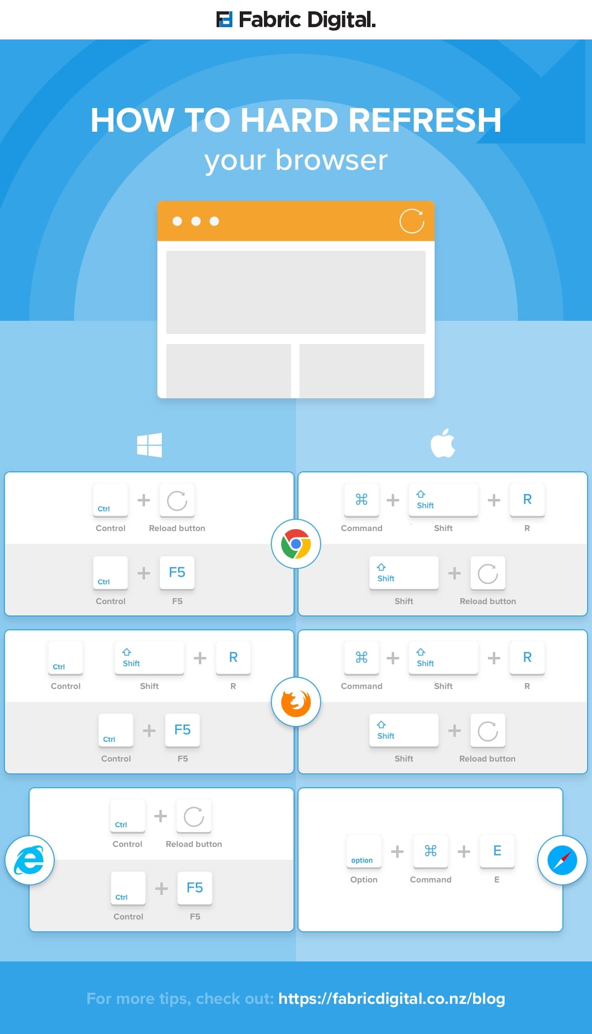
If you have trouble opening these links, then you will likely need to clear your browser cache. I found this article recently, with instructions on how to do that with different browsers. Caveat emptor, have not really tested them.
 fabricdigital.co.nz
https://boydsmaps.com/#15.00/39.585985/-74.459255/hybrid/0.00/0.00
Like other recent maps, the maximum resolution is 4 feet (1.2 meters).
https://boydsmaps.com/#17.00/39.843185/-75.149360/hybrid/0.00/0.00
Using the NAIP 2019 imagery here in New Jersey. Pennsylvania, Delaware and Maryland use a mix of other recent NAIP imagery. Was a bit of a jigsaw puzzle putting these irregularly-shaped aerials together, there are some glitches along the Delaware River where they meet. Also had a problem downloading from PASDA, finally gave up and used NAIP imagery from the USGS National Map in a section of Southeast Pennsylvania. That imagery is only available at level 16 resolution, so there's less detail when you zoom all the way into this (relatively small) area.
There are other things that could be improved, just noticed the trails (Batona, etc) are hard to see against the forest background, for example. May fix them one day, but moving on to the next map for now.
If you have trouble opening these links, then you will likely need to clear your browser cache. I found this article recently, with instructions on how to do that with different browsers. Caveat emptor, have not really tested them.
How to hard refresh your browser Chrome, Firefox, Safari
Hard refreshing your browser clears your cache and forces your browser to download a new copy of the website. This is extremely helpful when you developing a website and need to see new changes.
Here's something annoying  On my 2023 Topo, I labelled Sandy Ridge like the USGS 24k topo
https://boydsmaps.com/#15.00/39.776230/-74.609356/pines2023/0.00/0.00

I used the same base POI's on these new maps, but when I changed the fonts, the label rotation was apparently reset back to zero. I had made a mental note to check that and other rotated text but obviously never got around to it.
https://boydsmaps.com/#15.00/39.776230/-74.609356/hybrid/0.00/0.00

Fun fact - the dark streetmap compresses very efficiently as .png files, the whole map is under 2gb. But the hybrid map is another story completely, it weighs in at 56gb! Using .jpg instead of .png files would make it much smaller, but it wouldn't have the same clarity.
On my 2023 Topo, I labelled Sandy Ridge like the USGS 24k topohttps://boydsmaps.com/#15.00/39.776230/-74.609356/pines2023/0.00/0.00
I used the same base POI's on these new maps, but when I changed the fonts, the label rotation was apparently reset back to zero. I had made a mental note to check that and other rotated text but obviously never got around to it.
https://boydsmaps.com/#15.00/39.776230/-74.609356/hybrid/0.00/0.00
Fun fact - the dark streetmap compresses very efficiently as .png files, the whole map is under 2gb. But the hybrid map is another story completely, it weighs in at 56gb! Using .jpg instead of .png files would make it much smaller, but it wouldn't have the same clarity.
FInally... the light-themed street map is now available. Basically the same dataset as the dark map, but you'll find some differences here and there, resulting from hand-tweaking each map. Property lines show at zoom levels 14 - 17, buildings on levels 15 - 17.
https://boydsmaps.com/#15.00/39.596581/-74.877334/lightstreets/0.00/0.00

Again, maximum resolution is 4 ft/pixel (level 17)
https://boydsmaps.com/#17.00/39.601201/-74.346390/lightstreets/0.00/0.00

You may find this map (and the dark version) useful for browsing parcel data in the pinesXT app
https://boydsmaps.com/pines/#16/39.618844/-74.495154/lightstreets/0/0/

Compare the light and dark versions with the sync app!
https://boydsmaps.com/sync/#16/39.619551/-74.774442/lightstreets/0/0/darkstreets/16/0/0

(Usual disclaimers about clear your cache apply)
https://boydsmaps.com/#15.00/39.596581/-74.877334/lightstreets/0.00/0.00
Again, maximum resolution is 4 ft/pixel (level 17)
https://boydsmaps.com/#17.00/39.601201/-74.346390/lightstreets/0.00/0.00
You may find this map (and the dark version) useful for browsing parcel data in the pinesXT app
https://boydsmaps.com/pines/#16/39.618844/-74.495154/lightstreets/0/0/
Compare the light and dark versions with the sync app!
https://boydsmaps.com/sync/#16/39.619551/-74.774442/lightstreets/0/0/darkstreets/16/0/0
(Usual disclaimers about clear your cache apply)
Just for fun, I did some comparisons between these new maps and HERE maps on my phone (the HERE WeGo app). If anybody thought I was ripping off HERE, this should put that to rest. My goals are obviously very different from theirs. Not "better" or "worse", just "different".
Dark Map


Light Map


Hybrid Map


My goals are obviously very different from theirs. Not "better" or "worse", just "different".Dark Map
Light Map
Hybrid Map
Yellow is for county routes such as Rt 563, I wouldn't consider that a "super highway" myself. ") Interstate highways and toll roads are green, state and US highways are red. The MAP is just a bunch of BS to me, I pay no attention to it. But the unpaved roads on these three new maps were taken from USGS 24k legacy topo's and not a mix of data from different sources like my older maps.
Interstate highways and toll roads are green, state and US highways are red. The MAP is just a bunch of BS to me, I pay no attention to it. But the unpaved roads on these three new maps were taken from USGS 24k legacy topo's and not a mix of data from different sources like my older maps.
Interstate highways and toll roads are green, state and US highways are red. The MAP is just a bunch of BS to me, I pay no attention to it. But the unpaved roads on these three new maps were taken from USGS 24k legacy topo's and not a mix of data from different sources like my older maps.One of the things that I liked about the HERE street maps is they have both mobile and desktop versions. I had it setup to automatically choose the version based on your device preference. Was road-testing the new streetmaps the other day, and the labels were just too small for me to easily read in the car, even on my 10-inch iPad screen.
So, I made a new mobile version of the light street map, it will be automatically chosen if you use mobile mode on a phone or tablet. Same map, but larger street names and route numbers. Will see how I like it and may make a similar version of the dark map. You don't need to do anything, the system will automatically choose the version based on your device preference.
Original (desktop) light streetmap

New mobile version. Fewer street names are shown, due to the much larger font. This is similar to the HERE mobile versions.

So, I made a new mobile version of the light street map, it will be automatically chosen if you use mobile mode on a phone or tablet. Same map, but larger street names and route numbers. Will see how I like it and may make a similar version of the dark map. You don't need to do anything, the system will automatically choose the version based on your device preference.
Original (desktop) light streetmap
New mobile version. Fewer street names are shown, due to the much larger font. This is similar to the HERE mobile versions.
Last edited:
A mobile version of the dark streetmaps is now available. Like the light version, you don't need to do anything, the mobile version is automatically used when your device is set to mobile mode. If you're using the app on a computer in desktop mode, you won't ever see this version. I tweaked some colors, most notably the minor roads are less bright so that the names will stand out.
Desktop version

New mobile version

Also notice how the Parkway is now identified with icons, like other highways. This was a feature I thought about adding to all these new maps but decided against it. Gave it a try here and will probably add the icons to the other versions of the new maps (eventually). The NJ and PA turnpikes also have new icons as does the Atlantic City Expressway.

Desktop version
New mobile version
Also notice how the Parkway is now identified with icons, like other highways. This was a feature I thought about adding to all these new maps but decided against it. Gave it a try here and will probably add the icons to the other versions of the new maps (eventually). The NJ and PA turnpikes also have new icons as does the Atlantic City Expressway.
Originally had not planned to do it, but I went ahead and made a mobile version of the hybrid map. My concern had been that the original hybrid map is about 56gb and I didn't want to devote that much space to another version. The original is compressed as .png images, which typically provides the best detail., but I decided to try using .jpg files for the mobile version. Looks pretty good and the whole map is only 6gb!
Like these other maps, you don't need to do anything, if you're using mobile mode in the app, the new version will automatically be chosen. With the desktop setting, there will be no change. Usual cache disclaimers apply.
New mobile version

Original desktop version

Like these other maps, you don't need to do anything, if you're using mobile mode in the app, the new version will automatically be chosen. With the desktop setting, there will be no change. Usual cache disclaimers apply.
New mobile version
Original desktop version
Ugh, it's gonna be harder to get away from proprietary maps than I thought. I removed all mapbox data from boydsmaps and am only using their API to display the 3d maps that I host myself. Turns out, everytime somebody loads one of these maps, it creates a billable event just because the Mapbox API is being used. I get 50,000 for free every month and only 10,000 were used in the past 30 days, so no problem yet. However, back in November, there were only about 5,000 so usage is clearly growing.
Will need to address this soon. Mapbox used to be open source but they quietly changed that awhile ago. There's an older open source version being developed as an alternative at Github. Will see if that's a viable alternative.
I've also noticed that people are using the 3d versions of the LIDAR maps when they really shouldn't be (these are the maps shown in blue in the menu). If you're viewing a map in 2d, don't use the 3d version. Aside from the fact that it might cost me money, you have to load twice as much data (elevation + map) which makes it slower and your computer/phone works harder. The image quality will also be a little worse due to perspective/parallax. I realize this is confusing, so I'll write some new code that just removes the 3d maps from the menu if you're using a 2d view.
To be clear, the 2d versions are the the four maps below the blue 3d versions on the menu:

Use the 2d map for this type of view.
https://boydsmaps.com/#17.00/39.807194/-74.589592/midatlidar/0.00/0.00

You should only use the 3d (blue) maps for 3d views, such as this
https://boydsmaps.com/#17.49/39.807194/-74.589592/mbx3dmidatl/-25.20/74.20

Will need to address this soon. Mapbox used to be open source but they quietly changed that awhile ago. There's an older open source version being developed as an alternative at Github. Will see if that's a viable alternative.
I've also noticed that people are using the 3d versions of the LIDAR maps when they really shouldn't be (these are the maps shown in blue in the menu). If you're viewing a map in 2d, don't use the 3d version. Aside from the fact that it might cost me money, you have to load twice as much data (elevation + map) which makes it slower and your computer/phone works harder. The image quality will also be a little worse due to perspective/parallax. I realize this is confusing, so I'll write some new code that just removes the 3d maps from the menu if you're using a 2d view.
To be clear, the 2d versions are the the four maps below the blue 3d versions on the menu:
Use the 2d map for this type of view.
https://boydsmaps.com/#17.00/39.807194/-74.589592/midatlidar/0.00/0.00
You should only use the 3d (blue) maps for 3d views, such as this
https://boydsmaps.com/#17.49/39.807194/-74.589592/mbx3dmidatl/-25.20/74.20