Impassible roads

scubabruce

Scout
Jul 1, 2011
86
21
ATCO, NJ
Thanks for the information. I appreciate any future updates as you hear things improve, as well. Sounds like our group should add the Mullica above Atsion L. to our list, as we love the upper Batsto. We are all using manueverable solo canoes, tight channels are a fun challenge!

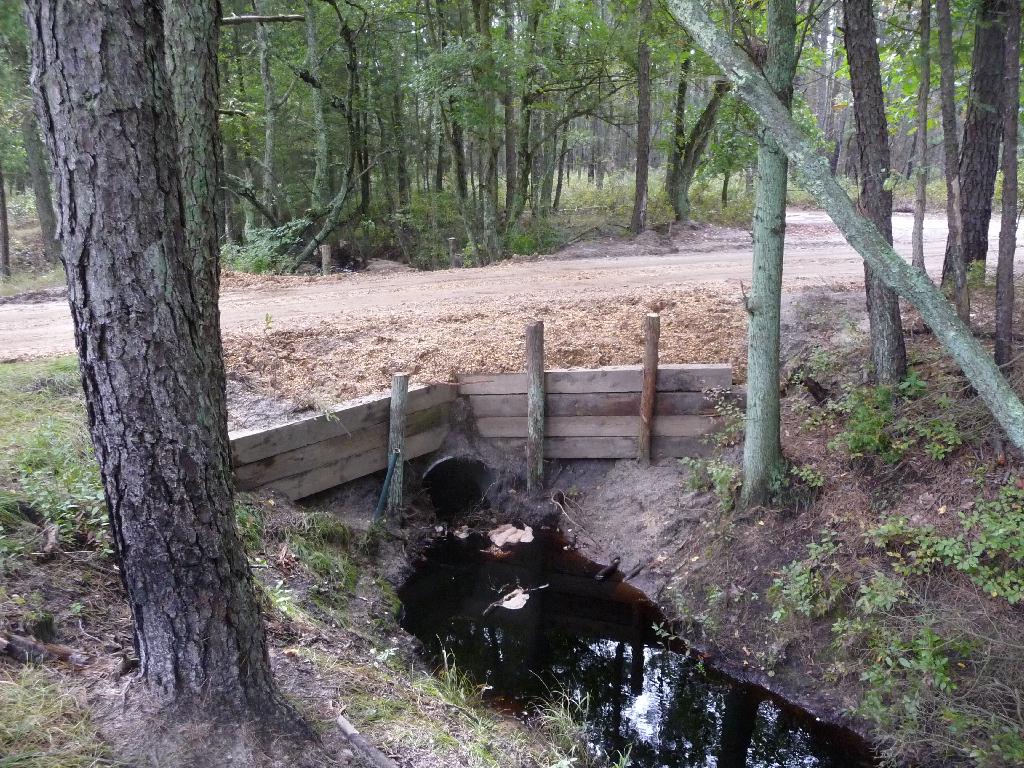
To share what I've learned since posting: On Wednesday I phoned the Atsion office of Wharton State Forest. I was told, in short, that both the Batsto and Mullica rivers are designated "CLOSED" by the State Forest because they are still "too high", and because emergency vehicle access is not possible due to significant sand road damage (if a paddler should need to be rescued). I always assume I'm on my own "out there", but I guess the state has a liability concern if they can't rescue an ill, injured or stranded visitor. I didn't ask if they issue trespass citations/fines to violators of the closures.

I was told to check back weekly; the forest staff is in the woods every day evaluating and will reopen sections of the river to paddling as soon as access improves.

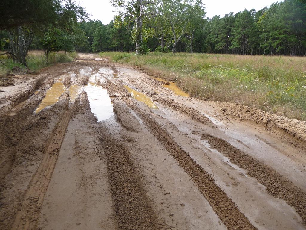
I just did the Oswego River on Wednesday. It was the only river open at the time and it was really moving fast (I flipped my kayak); however, the water level was receding and it should be very doable unless we get more heavy rain. I also did the Mullica above Atsion Lake about a month ago after heavy rains, putting in at Goshon Pond. It's cleared for a distance, but not all the way to Jackson Road in ATCO. Some heavy timber down so expect to do some liftovers if you take that route. Best advice is to call Micks (800-732-0793) or Bell Haven (800-445-0953) and they will give you the scoop on river conditions for the Mullica, Batsto and Oswego. Rt 542 at Basto has been closed (don't know if it's open yet) pending a bridge inspection. The bridge is intact but needs an inspection. This has prevented Bell Haven from picking up people at Pleasant Mills and Batsto Lake. In addition, I understand that the dirt road leading into the canoe launch area at Basto Lake was affected, so call Bell Haven for a status report. The Great Egg Harbor River above Lake Lenape may be another option. Call the Winding River camp ground for a status report.
 

scubabruce

Scout
Jul 1, 2011
86
21
ATCO, NJ
I talked to the folks at Bel Haven today - Rt 542 at Batsto is closed indefinitely - the problem is the bridge at Pleasant Mills, and the one at Batsto needs to be inspected. Batsto Lake is not accessable now but may be later if the bridge ever gets inspected and passes. Micks was doing a booming business putting folks into the Wading and Oswego rivers.
 

Christie Post

New Member
Sep 13, 2011
4
0
59
Thanks again, all who have responded. Our group is still undecided two weeks from the planned dates, but we're encouraged that it doesn't appear to be a total bust.

As far as the Oswego, does it truly get "drained" for cranberry harvest to the point it can't be paddled by skilled canoeists (as the paddling guides caution), and if so, is the drawdown likely to occur during early-to-mid October? Is there any way to know when and for how long?

If we can count on the Oswego, we will probably make the trip.
 

Teegate

Administrator
Site Administrator
Sep 17, 2002
25,627
8,228
With the weather we have been having the Oswego will be good. However, the state has been planning on building a foot bridge across the river at Martha but nothing really seems to be happening with that. But if by chance they do start on it they will have to block the river downstream. I say the chances of that are remote.

If you have never been on the Oswego you drop off at the parking area and paddle across the lake to the dam. Carry across and put in on the other side of the dam.

Guy
 

ecampbell

Piney
Jan 2, 2003
2,841
964
I drove by the canoe launch at Atsion this morning, it is still marked as " CLOSED TO PUBLIC USE". The river is fast and I wouldn't launch there right now. Too many twist and turns which will pin you aginst the banks.
The road closed sign at Quaker Bridge Road is moved to the side.
 

ecampbell

Piney
Jan 2, 2003
2,841
964
The bridge at Hampton Furnace has been repaired. They are using cedar posts to hold the ties in place.


They also dumped some fill in the holes in the road and made a real mess.
 

Teegate

Administrator
Site Administrator
Sep 17, 2002
25,627
8,228
It looks to me that it may wash out at the bottom of the ties. They need at least one more at the bottom.

Guy
 

Christie Post

New Member
Sep 13, 2011
4
0
59
Hi all who provided helpful information. To follow up, our small group (from mostly western PA) did our trip to the Pine Barrens two weekends ago. We had perfect weather. To avoid the long detour at Pleasant Mills bridge, we opted to paddle the Mullica above Atsion Lake; the Wading from Godfrey Br to Evans Br; and the Oswego. The second and third days were uneventful except for being relaxed, beautiful trips.

The Mullica was quite an adventure! In spite of being warned against putting in at Jackson Rd, that's what we did, because we couldn't find any reference to Atco in Parnes' paddling guidebook. It looked like there is an upstream access also along Jackson Rd, so we thought we were safe with the downstream entry.

According to the GPS of one in our party, at almost two hours we had gone only 1,600 feet! We had brief stretches where the going was clear, but where it was obstructed, it was nearly impassible, often because the foliage along the banks was too thick to get through.

Well, I can't say we weren't warned! Long story short, everyone ended up having a relatively fun time, and most of the stress was because one of our group had a time constraint we were trying to meet. We all agreed later that had we been better equipped to clear some of the bigger obstructions and no time constraint, it would have been all good. (We only had small folding saws. Loppers, pruners and a small chainsaw would have made all the difference.)

I'm enjoying this forum and will add it to my favorites.

CP
 

Teegate

Administrator
Site Administrator
Sep 17, 2002
25,627
8,228
Glad you had a pretty good time. Thanks for posting your report.

Guy
 

ecampbell

Piney
Jan 2, 2003
2,841
964
The downed tree on Push Line Road has been cleared. The washout at the gravel hill has been filled in.
 

Teegate

Administrator
Site Administrator
Sep 17, 2002
25,627
8,228
So they are steadily and slowly working on things out there.
 

Gibby

Piney
Apr 4, 2011
1,640
442
Trenton
I had questioned Teegate earlier in this thread about clay pipes that were exposed by the hurricane along the side of the road that runs through Hampton Park. We both saw them and never went further than agreeing that they were there. The pipes were along the edge of field in the second photograph in ecampells post above, but one puddle/hole before it. I was lucky enough to get several pictures of them before the void was filled in. I don't know if they were once part of sewer system for the couple buildings that once existed here or modern drainage that was put in by the state.

pipe.jpg
 

46er

Piney
Mar 24, 2004
8,837
2,143
Coastal NJ
For whomever might be considering a trip to the DWGNRA; there are many road & facility closures up there. I was there yesterday, the main detours for me was the Big Flatbrook bridge & Rt 615 on the northside up to the campground are closed and Old Mine Road from Millbrook Village to the bridge are closed. Old Mine Road from RT80 to Millbrook is open, but a few areas are closed, like Van Campens. It is a LONG detour from Millbrook village out to rt94 to rt206 to rt615. Millbrook is a disaster zone. On the PA side there are more closures, primarily around Dingmans Ferry and VC, but I never got over there. Spoke with the folks at the Kittatiny Point VC and they have no idea when things will be repaired. They had just finished repairing the damage from the last big flooding incident. The NPS site for DWGNRA has some pictures of the damage. I would imagine todays storm will only make things worse.
It was nice to go on a weekday and miss the crowd at Hot Dog Johnnys :smug:
 
Top