Bob, If you drive in the main entrance on Lakehurst Rd. you will come to a stop sign at the intersection in front of the general store. Go straight and as you said about 1/4 mile there is the hill where if you were driving you would slow down because the road is narrow and you can't see if anyone is coming from the other direction. Did you stop at the settlement of Whitesbog or was there something else hidden in the woods? BTW The Whitesbog Blueberry Festival is on June 27 this year.
Jemima Mount
- Thread starter Kevinhooa
- Start date
You are using an out of date browser. It may not display this or other websites correctly.
You should upgrade or use an alternative browser.
You should upgrade or use an alternative browser.
Uploaded the photos to my Flickr Page. Link to the set is:
http://www.flickr.com/photos/kevinhooa/sets/72157619648109049/
Kind of difficult to really see the size of this place, so I may try and go back at night to illuminate it with flashes. Or at least on a cloudy day so there's less contrast. Enjoy.
http://www.flickr.com/photos/kevinhooa/sets/72157619648109049/
Kind of difficult to really see the size of this place, so I may try and go back at night to illuminate it with flashes. Or at least on a cloudy day so there's less contrast. Enjoy.

South Jersey is Backwards!
Gabe,
You are correct. Our high points began as old (i.e., Miocene age) river bottoms. In places where streams changed their course, gravels where deposited. In places where water flow was sluggish and swampy, ironstone would form. As rivers changed course the abandoned channel floors became hardened caps that were more resistant to erosion than the softer old riverbanks. This is called inverted relief. Wearing away of the landscape (i.e., denudation) occurred over a very long time, with a significant amount of slope modification taking place at the end of permafrost episodes during the ice age.
Detailed overviews of Pine Barrens geologic history can be found in Stanford (2003) and Newell et al. (2000). Both are pretty much in agreement with the Late Tertiary material. The former paper deemphasized the role of cold-climate processes in sculpting the landscape, and attributes the current landscape to fluvial incision and erosion. The latter work suggested that the Coastal Plain is a badlands landscape with periglacial (i.e., cold, nonglacial) mass wastage assigned to sustained cold periods during the Pleistocene. Newell recognized South Jersey's periglacial past while doing fieldwork during the early 1980s, but had little opportunity to publish. He was simply too far ahead of his time. For new details on Pinelands cold-climate landscape modification see French et al. (2007).
French HM, Demitroff M, Forman SL, Newell WL. 2007. A Chronology of Late-Pleistocene permafrost events in southern New Jersey, eastern USA. Permafrost and Periglacial Processes. 18: 49-59.
Newell WL. 2005. Evidence of cold climate slope processes from the New Jersey Coastal Plain: debris flow stratigraphy at Haines Corner, Camden County, New Jersey. U.S. Geological Survey, Open-File Report 2005-1296. July 2005. Version 1.0. Unpaginated. http://pubs.usgs.gov/of/2005/1296/
Newell WL, Powars DS, Owens JP, Stanford SD, Stone BD. 2000. Surficial geologic map of central and southern New Jersey. United States Geological Survey, Miscellaneous Investigations Series, Map 1-2540-D, Washington, DC.
Stanford SD. 2003. Late Miocene to Holocene geology of the New Jersey Coastal Plain. In Hozik, MJ, Mihalasky MJ (eds.). Periglacial Features of Southern New Jersey: Field Guide and Proceedings, 20th Annual Meeting of the Geological Association of New Jersey, October 10-11, 2003. Trenton, NJ: Geological Association of New Jersey. pp. 21-49.
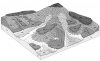
Figure 1 Block diagram showing schematic relationship between surficial materials and South Jersey landforms. High flat areas are known as "relict plateaus." From Newell et al. (2000: Figure 4).
My understanding is that our SJ hills are scattered remnants of sandy/gravelly river bottoms that have largely eroded away.
Gabe,
You are correct. Our high points began as old (i.e., Miocene age) river bottoms. In places where streams changed their course, gravels where deposited. In places where water flow was sluggish and swampy, ironstone would form. As rivers changed course the abandoned channel floors became hardened caps that were more resistant to erosion than the softer old riverbanks. This is called inverted relief. Wearing away of the landscape (i.e., denudation) occurred over a very long time, with a significant amount of slope modification taking place at the end of permafrost episodes during the ice age.
Detailed overviews of Pine Barrens geologic history can be found in Stanford (2003) and Newell et al. (2000). Both are pretty much in agreement with the Late Tertiary material. The former paper deemphasized the role of cold-climate processes in sculpting the landscape, and attributes the current landscape to fluvial incision and erosion. The latter work suggested that the Coastal Plain is a badlands landscape with periglacial (i.e., cold, nonglacial) mass wastage assigned to sustained cold periods during the Pleistocene. Newell recognized South Jersey's periglacial past while doing fieldwork during the early 1980s, but had little opportunity to publish. He was simply too far ahead of his time. For new details on Pinelands cold-climate landscape modification see French et al. (2007).
French HM, Demitroff M, Forman SL, Newell WL. 2007. A Chronology of Late-Pleistocene permafrost events in southern New Jersey, eastern USA. Permafrost and Periglacial Processes. 18: 49-59.
Newell WL. 2005. Evidence of cold climate slope processes from the New Jersey Coastal Plain: debris flow stratigraphy at Haines Corner, Camden County, New Jersey. U.S. Geological Survey, Open-File Report 2005-1296. July 2005. Version 1.0. Unpaginated. http://pubs.usgs.gov/of/2005/1296/
Newell WL, Powars DS, Owens JP, Stanford SD, Stone BD. 2000. Surficial geologic map of central and southern New Jersey. United States Geological Survey, Miscellaneous Investigations Series, Map 1-2540-D, Washington, DC.
Stanford SD. 2003. Late Miocene to Holocene geology of the New Jersey Coastal Plain. In Hozik, MJ, Mihalasky MJ (eds.). Periglacial Features of Southern New Jersey: Field Guide and Proceedings, 20th Annual Meeting of the Geological Association of New Jersey, October 10-11, 2003. Trenton, NJ: Geological Association of New Jersey. pp. 21-49.
Figure 1 Block diagram showing schematic relationship between surficial materials and South Jersey landforms. High flat areas are known as "relict plateaus." From Newell et al. (2000: Figure 4).
Attachments
Here is a photo of Jemima Mount in 1979. This was the only route up the hill then.

Guy
I agree. There's been alot of damage since I was last there! In the 60's, I don't remember any soil showing, just a detrius covered trail! I wonder how long at this rate it will become the size of "Willy's Hill"?
Mountains
Thanks to everyone for the information provided. Spung-man, thanks a lot for that explenation about the eroded riverbeds. That clears up a lot of mysteries about why the dirt was colored the way it was and why there was such a concentration of gravel. That's pretty neat. Using this info I think I'll spend a night or two with my huge topo of the Atsion to New Gretna area and do some paper exploring. I know there's nothing really amazing about the heights of these hills and mountains, but when the average height above sea level is 30ft. to 80ft., something like 200ft. is something really neat to see. And their just another part of what makes this area so unique. Thanks again.
Kevin
And their just another part of what makes this area so unique.
Kevin
Hi Kevin,
Pinelands hills are fascinating inside and out! In old Piney speak, they’re often referred to as “buck hills.” Does anyone know the reason for this archaic designation? Has anyone used mounts as hunting resources?
Spung-Man
Hi Kevin,
Pinelands hills are fascinating inside and out! In old Piney speak, they’re often referred to as “buck hills.” Does anyone know the reason for this archaic designation? Has anyone used mounts as hunting resources?
Spung-Man
Maybe the Bucks go on them to keep watch for trouble?
Guy
cold, dry, windy
Furball,
Indeed, the ancient cold climate mass wastage of Pine Barrens terrain and the presence of submerged bones are linked. Warm, wet interglacial periods were the climatic exception, not the climatic norm for the last million+ years (i.e., the Pleistocene). North America’s Laurentide ice sheet at maximum was probably about 25% larger than the current Antarctic ice sheet. South Jersey is the sole remnant of North American ice marginal coastal plain. Its position accounts for many of the area's unusual “periglacial” landforms, and that is what makes the Pinelands landscape so special (e.g., spungs, cripples, savannahs, dunes).
That rampageous thug, the Laurentide, on occasion parked itself as far south as Exit 12 on the New Jersey Turnpike. Ice age Pine Barrens experienced rigorous cold, dry, and windy conditions. Ocean depths dropped as much as 400 feet below today’s sea level, exposing vast stretches of now offshore slope for cold adapted critters to play upon. However Pleistocene New Jersey vegetation was sparse. At times the region resembled a polar-like semidesert, which likely limited faunal activity and probably accounts for the paucity of plant and animal remains dated to that period.
Spung-Man
Would this type of ancient erosion account for mastadon bones and the like found submerged out at sea?
Furball,
Indeed, the ancient cold climate mass wastage of Pine Barrens terrain and the presence of submerged bones are linked. Warm, wet interglacial periods were the climatic exception, not the climatic norm for the last million+ years (i.e., the Pleistocene). North America’s Laurentide ice sheet at maximum was probably about 25% larger than the current Antarctic ice sheet. South Jersey is the sole remnant of North American ice marginal coastal plain. Its position accounts for many of the area's unusual “periglacial” landforms, and that is what makes the Pinelands landscape so special (e.g., spungs, cripples, savannahs, dunes).
That rampageous thug, the Laurentide, on occasion parked itself as far south as Exit 12 on the New Jersey Turnpike. Ice age Pine Barrens experienced rigorous cold, dry, and windy conditions. Ocean depths dropped as much as 400 feet below today’s sea level, exposing vast stretches of now offshore slope for cold adapted critters to play upon. However Pleistocene New Jersey vegetation was sparse. At times the region resembled a polar-like semidesert, which likely limited faunal activity and probably accounts for the paucity of plant and animal remains dated to that period.
Spung-Man
here, here!
Let's hope those entrusted with the stewardship of this place share our sentiments.
thank God for the pinebarrens of today!
Let's hope those entrusted with the stewardship of this place share our sentiments.
Spungman,
How prevalent is ironstone in the Cohansey formation? I used to work at the golf course in Waretown (I know, 'tis a shame) where ironstone is virtually everywhere exposed. Was this ironstone formed via bacteria just as it is today in the Pine Barrens?
How prevalent is ironstone in the Cohansey formation? I used to work at the golf course in Waretown (I know, 'tis a shame) where ironstone is virtually everywhere exposed. Was this ironstone formed via bacteria just as it is today in the Pine Barrens?
Rocks in Gabe's head, tassels on his feet....
Good questions, Gabe,
As stated in an earlier Pinelands stone thread (link below), my discipline concerns only the last couple hundred thousand-years of Pinelands geologic history (i.e., Late Pleistocene). Still, I’ll try to simplify earlier events, as I understand them. Many people associate the Cohansey Formation with riverine sand from marine, marine marginal, estuarine, deltaic, and fluvial deposits of Miocene age (~23 to 5 million-years ago). But that’s only part of the story.
Throughout the Miocene Epoch sea level fluctuated, especially towards the Middle-to-Late Miocene when oceans progressively lowered as the Earth cooled. Ironstone would have formed during ground exposing lowstands, particularly at water table around swamps and river-bottoms. Ironstone continued to form by during ensuing warm periods, including interglacial intervals. The process continues today. Yes, the bacteria responsible for much of the ironstone formation have been precipitating iron oxide for a very, very long time.
The material that caps northern (i.e., above the Mullica River) Pine Barrens mounts was derived from the Beacon Hill facies of the Cohansey Formation, and is not a separate geologic entity as earlier supposed. Facies is a somewhat difficult interpretive concept, but basically means that different sedimentary environments can exist at the same time and that the same sedimentary environment can exist at different times. Since sea level was dropping, the ancient river(s) that brought Pine Barrens sediments was no longer near its lower and slower journey’s end where sands and clays deposit. Instead this watercourse was higher upstream so flowed with sufficient power to carry gravels and cobbles. Salients below the Mullica River are composed of younger (i.e., Late Miocene) Bridgeton Formation gravels and cobbles deposited over-top older Cohansey Formation sediments.
Gabe, you didn't have to wear those funny shoes at the club...
did you?
(also see earlier thread ? About differences in NJ Stones – http://forums.njpinebarrens.com/showthread.php?t=6414)
Spungman,
How prevalent is ironstone in the Cohansey formation? I used to work at the golf course in Waretown (I know, 'tis a shame) where ironstone is virtually everywhere exposed. Was this ironstone formed via bacteria just as it is today in the Pine Barrens?
Good questions, Gabe,
As stated in an earlier Pinelands stone thread (link below), my discipline concerns only the last couple hundred thousand-years of Pinelands geologic history (i.e., Late Pleistocene). Still, I’ll try to simplify earlier events, as I understand them. Many people associate the Cohansey Formation with riverine sand from marine, marine marginal, estuarine, deltaic, and fluvial deposits of Miocene age (~23 to 5 million-years ago). But that’s only part of the story.
Throughout the Miocene Epoch sea level fluctuated, especially towards the Middle-to-Late Miocene when oceans progressively lowered as the Earth cooled. Ironstone would have formed during ground exposing lowstands, particularly at water table around swamps and river-bottoms. Ironstone continued to form by during ensuing warm periods, including interglacial intervals. The process continues today. Yes, the bacteria responsible for much of the ironstone formation have been precipitating iron oxide for a very, very long time.
The material that caps northern (i.e., above the Mullica River) Pine Barrens mounts was derived from the Beacon Hill facies of the Cohansey Formation, and is not a separate geologic entity as earlier supposed. Facies is a somewhat difficult interpretive concept, but basically means that different sedimentary environments can exist at the same time and that the same sedimentary environment can exist at different times. Since sea level was dropping, the ancient river(s) that brought Pine Barrens sediments was no longer near its lower and slower journey’s end where sands and clays deposit. Instead this watercourse was higher upstream so flowed with sufficient power to carry gravels and cobbles. Salients below the Mullica River are composed of younger (i.e., Late Miocene) Bridgeton Formation gravels and cobbles deposited over-top older Cohansey Formation sediments.
Gabe, you didn't have to wear those funny shoes at the club...
did you?
(also see earlier thread ? About differences in NJ Stones – http://forums.njpinebarrens.com/showthread.php?t=6414)
Gabe, you didn't have to wear those funny shoes at the club...
did you?
Oh no, not AGAIN? He wore these at the last hike and was really annoying; whimpering about having to step over logs and getting the bows caught on lowbush blueberry.
http://www.shoeblog.com/wp-content/uploads/2008/04/ks-girly.jpg
Oh no, not AGAIN?
I meant golfing shoes, but I'm certainly relieved to see Gabe has better taste in footwear than presumed!
Mounts
Took a ride out to Devious Mt. today to see what that was all about, (thanks for the heads up on it James!) Pretty neat place. On the topo map it seemed like it rose up somewhat on the steep side, but really it's more gradual than it appeared. There's no road leading to it from the Tuckerton Stage rd., but there were motorcycle trails all over the place in front of it, and one led up and around over the top. It's not huge, but is pretty long. I mostly stayed on the trails to keep from getting covered in ticks. The top, where the trails were dug out, is made of dirt and pretty good sized gravel with a few baseball sized light grey stones.
After checking out the topo map it looks like there is another hill located about 1/2 mile south and has an elevation of exactly 1 foot higher than Devious. There's no name for this hill, and it seems like it rises up fast enough to warrant a name for itself. Might be worth a hike just to see what's up. lol.