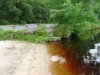
I found my photos which show a spot in the lawn where the culvert was collapsing. Photo doesn't let me know where it was but I can see I was taking photos between the house and garage. No reason to bother homeowner as there doesnt seem to be anything to learn about former forge from it's presence. Below is a photo of the inlet at the lake for the culvert:

Lakehurst, home of multiple forges?
- Thread starter Ryan Walton
- Start date
You are using an out of date browser. It may not display this or other websites correctly.
You should upgrade or use an alternative browser.
You should upgrade or use an alternative browser.
Two maps I have been going over have something to offer. The Lakehurst Walking tour map give the location of the small pond that used to be East of Lake Horicon. It shows both the culvert into the pond and a stream that feeds back into the Horicon Branch. The other is Boyd's lidar map. It provided a clue to a more exact location. There appears to be an intersecting wall line south of the properties that are on Church St. If you could lay one map over the other you would get a structure on the northeast side of the small pond. I believe this to be Federal furnace.
Very interesting what has been shared. I was forgetting about the second forge that was located further downstream. It still seems stranage that the culvert would go towards Church Street. The pond that was mentioned downstream seems like a point of interest.
Phoenix forge, which has been mentioned previously, resides nowhere in Lakehurst. Thanks once again to Boyd's lidar map with a comparison to a Google earth satellite photo, there is proof that the forge is where the Union Branch of the Toms River and the Manapaqua branch come together.
In the woods, directly behind the Manchester Library there appears to be another building like shape on the Lidar map.
I can't wait to have an opportunity to check it out.
In the woods, directly behind the Manchester Library there appears to be another building like shape on the Lidar map.
I can't wait to have an opportunity to check it out.
Thanks once again to Boyd's lidar map with a comparison to a Google earth satellite photo, there is proof that the forge is where the Union Branch of the Toms River and the Manapaqua branch come together.
Can you show us exactly what you are looking at on the LIDAR map?
Just in case you don't know how to do that... simply drag the map until the cross-hairs point to what you want and zoom to the desired level. Then just copy the entire URL and paste it into your post.

Of course. Here you go.
http://boydsmaps.com/#lidar,40.008586,-74.296517,16
Hmmm...I'm not sure what you are looking at there. Maybe try to pinpoint it with the live maps?
Thanks, Bobby. Have you poked around the Phoenix site?
Thanks, Bobby. Have you poked around the Phoenix site?
No, never did. What say ye we all pop over there some day?
I think the path of Manapaqua Brook may have been altered or the old map is just wrong since I don't believe that junction (of 2 brooks) is the correct location for the former Phoenix Forge. This is just my opinion and I could very well be wrong.
Hmmm...I'm not sure what you are looking at there.
Just a tip if you're using my LIDAR map. There's a very long thread here describing how I created it, and one of the issues is that a huge number of files are needed for each level of zoom in the map. Therefore I only allow you to zoom far enough to see each pixel in the image.
But you can use your web browser to zoom in farther, and even though it's just making big pixels out of little pixels, I think it helps show the detail. Typically you would use control + and control - to zoom in Windows or command + and command - to zoom on the Mac. Here's an example using Ryan's link.
Bob, that was the map I was trying to find! I had seen it, but could not find it again. the Lidar map backs up the old topo map with Phoenix marked on it.
Can anyone tell me what the lines north of Phoenix forge are on the lidar map?
Can anyone tell me what the lines north of Phoenix forge are on the lidar map?
.Can anyone tell me what the lines north of Phoenix forge are on the lidar map?
They have been there since the 30's at least. My guess is a canal or a couple cordoroy roads for logging.
http://www.lakehurstnj.org/walktour.html
This is the walking tour map. note the small pond that feeds back into the Union branch.
This is the walking tour map. note the small pond that feeds back into the Union branch.