Mapping Graves with a Trimble GPS

jfrady

New Member
May 19, 2020
9
18
Austin, TX
wikigrave.com
Thought I'd share this here as it may be of some interest to some. I photograph a lot of cemeteries and I have been collecting positional data of gravestones to help locate them in the future but also to look for relational data based on their positions. For example, if there is a large concentration of a family name in one part of the cemetery and then one lone outlier of the same family in another part of the cemetery, this raises some interesting questions.

For general photography, I use my iPhone with the built in GPS or my DSLR camera using the iPhone as an external GPS. For graves of personal special interest to me, I've started using a Trimble GPS to collect submeter positional data. I'm familiar with working with these units so I knew exactly which hardware version, firmware version, and software version/license I needed and was fortunate enough to find a unit that had the sweet spot I was looking for on eBay for cheap. Positional data is corrected in realtime using SBAS but can also be post corrected using the computer software. Data entry is a little tedious so I obviously can't use this for everything but does provide some great data to work with.

82704784_462945677706782_902321196656230400_o.jpg
 
  • Like
  • Love
Reactions: Boyd and bobpbx

manumuskin

Piney
Jul 20, 2003
8,633
2,552
60
millville nj
www.youtube.com
I have been all over South Jersey tracking down Graves of my ancestors and I did make gpx file.I"m sure I still have it but can't quite remember where I put it.Thnkfully I have n uncanny ability to go back to a spot I found many years ago so I think I can refind most of the graves.I do have the pics of them which may help if for some reason I can't find one. I came in contct with a first cousin while trying to do genealogy on my dads side,I never knew the family even though they live close by.She responded to a query I made on a message board and next thing i know she dumped her years of research on me and took me on a field trip of all my folks resting places,mabny I have driven by for years and never knew. I knew Moms roots went back to Appalachia and tidewater Va but knew nothing of my Dad.Turns out I have folks here in NJ about as long as they were in va.Early 1600s even.
 

Boyd

Administrator
Staff member
Site Administrator
Jul 31, 2004
9,706
2,910
Ben's Branch, Stephen Creek
I think it's very cool. But I'm afraid Trimble is above my pay grade. Will admit that I'm jealous though! :D Would be interested to hear more about @jfrady 's setup.
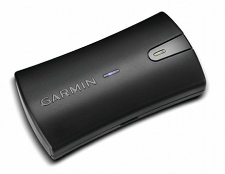
My GLO is accurate enough for anything I need to do and it works with any app on my iPhone, iPad, Android tablet or laptop. Have written a couple reviews over the years:


  • Like
Reactions: jfrady

jfrady

New Member
May 19, 2020
9
18
Austin, TX
wikigrave.com
I just checked my email, it was $150 back in January. The software license that it came with was a nice bonus. I used to provide tech support for Trimble devices at my previous job so I was familiar with this configuration.

Trimble GeoXT 2008
TerraSync 3.30 handheld software
GPS Pathfinder Office 4.20 desktop software (requires some effort to get it to work on Windows 7 and 10)

For collecting static positions, I'll hover over the spot and collect data for about 30 seconds, I'm usually entering in the name of the position while its collecting data. This will collect enough positional data to perform post processing on the computer using CORS reference station data freely available on the internet.

Serial out is avaliable with an add on module but I do not have one. I haven't had any success getting serial output over Bluetooth to work, additional software licensing might be required.
 
  • Like
Reactions: Boyd

Boyd

Administrator
Staff member
Site Administrator
Jul 31, 2004
9,706
2,910
Ben's Branch, Stephen Creek
Nice! I can see where you would need sub-meter accuracy to identify individual graves that are closely spaced. I wanted a device like that for a long time, but have mostly lost interest in GPS hardware over time and concentrated on maps. Don't really need to save position data with that kind of accuracy myself, but what you're doing is very cool! :cool:

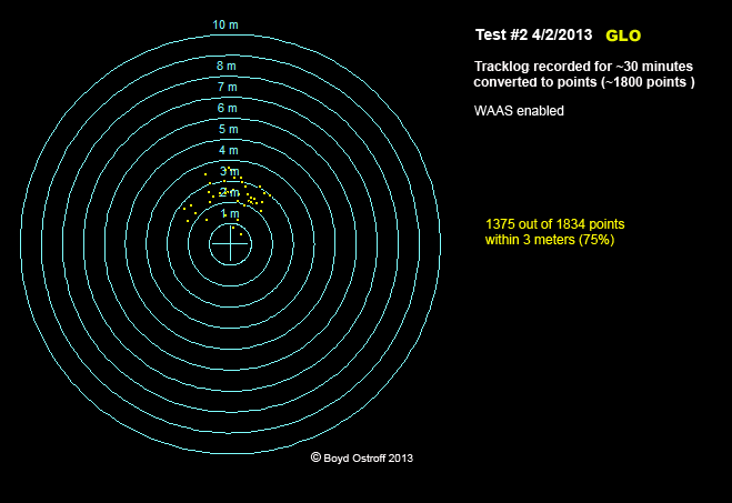
My Garmin GLO ($100 new - got mine on sale for $90) can usually get me within 2 or 3 meters, which is better than a Garmin handheld does. It provides 10 position updates per second over bluetooth, so with your example, I could use any number of smartphone apps and just record my track to a .gpx file for 30 seconds which would give me 300 points. I could then open the GPX file in Globalmapper and convert the line to individual points, which could be averaged or otherwise interpreted.

Here's a test I did a number of years ago, where the GLO was stationary for about 30 minutes and gathered ~1800 samples. The GLO was at the center of the bullseye and each ring is spaced one meter apart

GLO1.png


Here's a close-up

GLO2.png


It doesn't look like it, but there really are 1800 dots in that image - many of them are right on top of each other however! The way they're all tightly grouped North of the bullseye makes me wonder if some kind of software correction could improve accuracy? Is there a way to do this with data from a .gpx file? Or maybe from an NMEA stream? Or do you need a professional device (like a Trimble) with proprietary software? I have never looked into this, since I don't really need more accuracy. :)

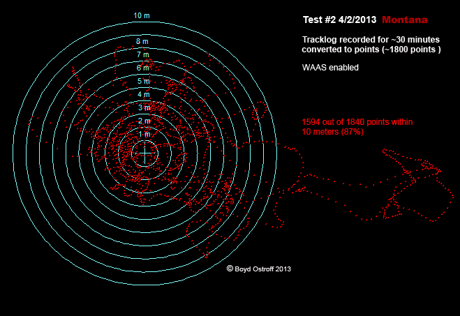
For users of Garmin handhelds, here are the results of the same test, performed at the same time with a Montana 600. As you can see, it "wanders" all over the place and is much less accurate than the GLO

montana.png


This is the venerable Garmin GPSMap 60csx that has been very popular. Again, not really in the same league as the GLO when it comes to recording static positions. But, to be fair, the Montana and 60csx performance was pretty close to the GLO driving on a sand road at 20 MPH. :)

60csx.png
 
Last edited:

jfrady

New Member
May 19, 2020
9
18
Austin, TX
wikigrave.com
Nice! I can see where you would need sub-meter accuracy to identify individual graves that are closely spaced. I wanted a device like that for a long time, but have mostly lost interest in GPS hardware over time and concentrated on maps. Don't really need to save position data with that kind of accuracy myself, but what you're doing is very cool! :cool:

My Garmin GLO ($100 new - got mine on sale for $90) can usually get me within 2 or 3 meters, which is better than a Garmin handheld does. It provides 10 position updates per second over bluetooth, so with your example, I could use any number of smartphone apps and just record my track to a .gpx file for 30 seconds which would give me 300 points. I could then open the GPX file in Globalmapper and convert the line to individual points, which could be averaged or otherwise interpreted.

Here's a test I did a number of years ago, where the GLO was stationary for about 30 minutes and gathered ~1800 samples. The GLO was at the center of the bullseye and each ring is spaced one meter apart

GLO1.png


Here's a close-up

GLO2.png


It doesn't look like it, but there really are 1800 dots in that image - many of them are right on top of each other however! The way they're all tightly grouped North of the bullseye makes me wonder if some kind of software correction could improve accuracy? Is there a way to do this with data from a .gpx file? Or maybe from an NMEA stream? Or do you need a professional device (like a Trimble) with proprietary software? I have never looked into this, since I don't really need more accuracy. :)

For users or Garmin handhelds, here are the results of the same test, performed at the same time with a Montana 600. As you can see, it "wanders" all over the place and is much less accurate than the GLO

montana.png


This is the venerable Garmin GPSMap 60csx that has been very popular. Again, not really in the same league as the GLO when it comes to recording static positions. But, to be fair, the Montana and 60csx performance was pretty close to the GLO driving on a sand road at 20 MPH. :)

60csx.png
Fascinating! The Garmin GLO looks like it would make a great companion for my DSLR camera in the future.
 
  • Like
Reactions: Boyd
Top