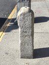
There is a milestone in downtown Haddonfield you may be familiar with. It's in front of Happy Hippo if you're unfamiliar.
Upon examining it, the hand points at Camden the correct way. The "Glou" side points north, up the Kings Highway, to a point roughly where Lenola Rd hits Kings Highway.
Why is this? If the hand to Glou pointed S down Kings Highway, it would hit where Kings Highway comes next to Timber Creek, a likely place for a town.
Has the sign been moved? I tried to triangulate as best as I could and found a spot around Westville where the distances and directions work.