Nice place to paddle and picnic

scubabruce

Scout
Jul 1, 2011
86
21
ATCO, NJ
Launched my kayak at the lower Batsto River beach Tuesday at high tide.
Batsto River Beach 001.jpg


Sand road going in is very narrow - saw glass from a lot of broken side mirrors on the way in. I paddled up the lower Batsto River about half way to the 542 bridge - the way was cleared up to that point but a tree across the river stopped me. I could have portaged around it but I wasn't dressed for wet. Came down the Batsto then went past Rabbit? Island, around the point and up the Mullica to the 542 bridge, then back down to the beach. This is a great location to kayak both lower rivers plus a nice picnic/swimming location.
Batsto River Beach 002.jpg

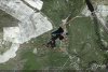
This is a view of Rabbit? Island from the beach. I didn't see the name of the island on any maps, but a hiker buddy of mine told me that's it's name. Anyway my qustion is......has anyone set foot on the island, or do you know anything about it? I've heard there were some fortifications at the Forks during the Revolutionary War. The Island would have been a good place to put them. Are there any reminants of those fortifications anywhere?
 
Apr 6, 2004
3,607
552
Galloway
Yep, that there be Rabbit Island. According to oral tradition, there were warehouses there in which spoils were stored. I've also heard that there was a military post there. None of this can be verified though. There are no remnants to be seen.
 

bushwacker

Scout
May 18, 2009
80
6
port republic
it looks like you put in from the beach at the end of forks rd, which is between the batsto and mullica rivers. Now I was told both bridges on 542 were out, was I misinformed? If not, how did you get there, through Batso village?

I have been on the island, I have seen evidence of the ocassional pirate camper, maybe a duck blind as well.
 

manumuskin

Piney
Jul 20, 2003
8,552
2,465
59
millville nj
www.youtube.com
I've been on that island and love it.Thats Gabe's neck of the woods. I was thinking of a clandestine campout on that island but you would be spotted from across the Mullica so it would be a no fire camp.It's very open and when I was there someone had set up a teepee of sticks like they were going to make a wikiup or maybe they were going to throw a tarp over it and camp.I didn't know the name till now,I called it The Forks island.
 

scubabruce

Scout
Jul 1, 2011
86
21
ATCO, NJ
it looks like you put in from the beach at the end of forks rd, which is between the batsto and mullica rivers. Now I was told both bridges on 542 were out, was I misinformed? If not, how did you get there, through Batso village?

I have been on the island, I have seen evidence of the ocassional pirate camper, maybe a duck blind as well.
Only the Pleasant Mills bridge is out. You can go over the 542 Batsto River Bridge but you have to approach it by taking the Pleasant Mills to Weekstown road, cross the Mullica and head back towards Batsto. Crossing the 542 Batsto River Bridge you can access that sand road in. You can also access the canoe/kayak launch area now at Pleasant Mills near that bridge going the direction described above, as well as the canoe/kayak launch area on Batsto Lake. BHP informed me that although Batsto Lake is now available for canoe pickup, they still can't get to Quaker Bridge for put in.
 

scubabruce

Scout
Jul 1, 2011
86
21
ATCO, NJ
are you saying we can get across this way?
No. I can't tell for certain from your map cause it's too small, but there's a second road closure at Pleasant Mills near Nescochague Lake. Coming from the direction of Hammonton on 542 you have to take the Pleasant Mills to Weekstown Road at its fork with 542 cause 542 is blocked at that point. Continue on Pleasant Mills to Weekstown Road (past Joe Mulliner's grave stone) to the Mullica River crossing at Greenbank, then head back to Batsto in the direction of Hammonton on 542 and cross the Batsto River.
 

manumuskin

Piney
Jul 20, 2003
8,552
2,465
59
millville nj
www.youtube.com
Oh ,I thought you were saying you could get across the Batsto using 542 when all the signs say otherwise.I have been crossing at green bank anyway but i come into Weekstown from Elwood.It lets me avoid Hammonton altogether.
 

scubabruce

Scout
Jul 1, 2011
86
21
ATCO, NJ
I thought you couldn't cross the Batsto River.
Can you place the pointer?
http://maps.njpinebarrens.com/#lat=39.64180131233001&lng=-74.65508222579956&z=15&type=k&gpx=
Yes - you can cross the Batsto River now on 542 as of about 2 weeks ago IF you are headed on 542 in the direction of Hammonton, but you can't cross the Pleasant Mills bridge on 542. The Batsto River bridge was never damaged, they closed it until they had a chance to inspect it for damage which they did, and it passed. However, you can't cross the Batsto River on 542 going the other way because the Pleasant Mills bridge (which comes first) is still closed (big hole in the road). I'm not sure what you want me to put the pointer on. So....if you want to get to Batsto from Hammonton, you have to do a loop; i.e. go around the Weekstown side of the Mullica, cross over at Greenbank and come down 542 from that direction. There is a sign at that crossing near BHP that says 542 is closed except to local traffic AND BATSTO. Just go around the road block sign at BHP and head toward Batsto.
 

manumuskin

Piney
Jul 20, 2003
8,552
2,465
59
millville nj
www.youtube.com
but can you detour the 542 pleasant mills bridge by going around nescohague lake as I showed on the image or is the bridge on pleasant mills weekstown road also out? It makes no sense to be able to go over the 542 batsto bridge at all if there is no place you can get to on the other side except perhaps the church?
Al
 

scubabruce

Scout
Jul 1, 2011
86
21
ATCO, NJ
There's another road outage near Nescohague lake - not sure of the location. However, if you do the loop I described above you'll have access to Batsto Lake, Batsto village, the beach and the kayak/canoe launch at the Pleasant mills bridge. You have to take the loop in the opposite direction to go back to Hammonton. The loop is an extra 20 minutes from the normal time to go from Hammonton to Batsto. FYI - the South Jersey Outdoor club is having a Halloween hike on Oct 31st at 10:00 AM to the lower Batsto River beach I discussed (contact romason@comcast.net). I was really impressed with this beach because it's nice and there was no trash. It would be an ideal camping area if the state widened the road in, except that it's really too nice for the general public in my humble opinion.
 
Top