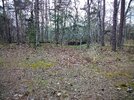
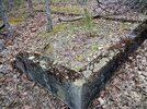
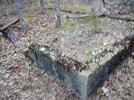
Recently I was biking through this park and noticed an old foundation I'd never noticed before. In the 1980s I found some distinctive "holes" or possibly some kind of old sewage "manholes" in the ground in this area. Today, the park is run by Atlantic County as a campground/recreational area. However, there is no indication or mention of this area's historical use. I always thought it was just a wooded area, but after discovering the foundation the other day, it is evident that something was here. Does anyone have any ideas or knowledge of this area? I tried looking at Boyds Maps but nothing resembling any structures appear in the older maps.

Ruins at Lake Lenape West, Mays Landing, NJ
- Thread starter EddieD
- Start date
You are using an out of date browser. It may not display this or other websites correctly.
You should upgrade or use an alternative browser.
You should upgrade or use an alternative browser.
Can you ping the location so we can take a look?Recently I was biking through this park and noticed an old foundation I'd never noticed before. In the 1980s I found some distinctive "holes" or possibly some kind of old sewage "manholes" in the ground in this area. Today, the park is run by Atlantic County as a campground/recreational area. However, there is no indication or mention of this area's historical use. I always thought it was just a wooded area, but after discovering the foundation the other day, it is evident that something was here. Does anyone have any ideas or knowledge of this area? I tried looking at Boyds Maps but nothing resembling any structures appear in the older maps.
To "
Since the time I've asked this question, I have learned from a Park ranger that he belives (he's not sure) that the area was once some sort of labor camp for the nearby Atlantic Blueberry Farms Co. in Mays Landing/Hammonton NJ.
Here are some pics showing the foundational ruins I have found at this location.
pinelandpaddler" So sorry for not replying to your question. It's been a while sine I've had the spare time to get back on this site and go get the location coordinates for you. Here are the coordinates and some pics. I hope the GEO software I used was accurate enough.
Latitude: 39°27'31.190"N Longitude: -74°44'18.437"W
Since the time I've asked this question, I have learned from a Park ranger that he belives (he's not sure) that the area was once some sort of labor camp for the nearby Atlantic Blueberry Farms Co. in Mays Landing/Hammonton NJ.
Here are some pics showing the foundational ruins I have found at this location.
Attachments

To "Can you ping the location so we can take a look?
@pinelandpaddler" So sorry for not replying to your question. It's been a while sine I've had the spare time to get back on this site and go get the location coordinates for you. Here are the coordinates and some pics. I hope the GEO software I used was accurate enough.
@Latitude: 39°27'31.190"N Longitude: -74°44'18.437"W
Since the time I've asked this question, I have learned from a Park ranger that he belives (he's not sure) that the area was once some sort of labor camp for the nearby Atlantic Blueberry Farms Co. in Mays Landing/Hammonton NJ.Here are some pics showing the foundational ruins I have found at this location.
Attachments
-

IMG_20220427_172128.jpg
2.6 MB · Views: 0 -

IMG_20220427_172148.jpg
2.7 MB · Views: 0 -

IMG_20220427_172153.jpg
1.4 MB · Views: 0
FWIW, it would be a lot easier for people to help if you convert your coordinates to decimal degrees, they are the standard for the digital age! ")
O. Okay. I'll keep that in mind. LOL! I actually copied these and pasted them directly from my little "free" GEO app on my cell phone. I think its by "examobile.com" and is simply called "GPS Data." So, guess I'll either translate it or find another app that gives digital readings...thanks for the heads up!FWIW, it would be a lot easier for people to help if you convert your coordinates to decimal degrees, they are the standard for the digital age!
My app is free and will work on your phone (as long as you have cell signal). Press the Coordinates button on the main menu for coordinates, or use the Share button and copy a link to the actual map you're viewing, then just paste it into your post here. Here's an aerial view of Mays Landing, for example:
https://boydsmaps.com/#17.00/39.453720/-74.739216/mbxhybrid/0.00/0.00
Or use the LIDAR map to find ruins:
https://boydsmaps.com/#17.00/39.453720/-74.739216/midatlidar/0.00/0.00
https://boydsmaps.com/#17.00/39.453720/-74.739216/mbxhybrid/0.00/0.00
Or use the LIDAR map to find ruins:
https://boydsmaps.com/#17.00/39.453720/-74.739216/midatlidar/0.00/0.00
Okay, cool. Now I also see, the app I was using was not too accuarate. After looking at your maps, I think the correct coordinates would be https://boydsmaps.com/#19.00/39.458636/-74.738765/midatlidar/0.00/0.00 Thanks!My app is free and will work on your phone (as long as you have cell signal). Press the Coordinates button on the main menu for coordinates, or use the Share button and copy a link to the actual map you're viewing, then just paste it into your post here. Here's an aerial view of Mays Landing, for example:
https://boydsmaps.com/#17.00/39.453720/-74.739216/mbxhybrid/0.00/0.00
Or use the LIDAR map to find ruins:
https://boydsmaps.com/#17.00/39.453720/-74.739216/midatlidar/0.00/0.00
I've walked by this foundation many times, and I always thought it was the ruins of an old bath house or something from the park. However, this area was someone's property in the late 19th/early 20th centuries.
You can see the house in this panorama from 1910:
https://tile.loc.gov/storage-services/master/pnp/ds/02500/02578u.tif
(Library of Congress)
It looks like the house was in the area where the boathouse and parking lot are now. The foundation could be from the same era?
You can see the house in this panorama from 1910:
https://tile.loc.gov/storage-services/master/pnp/ds/02500/02578u.tif
(Library of Congress)
It looks like the house was in the area where the boathouse and parking lot are now. The foundation could be from the same era?
Oh! Hey! The picture(s) are fascinating! I never knew there was so many houses in this area! I knew it from the 80s (before it became part of the "Lake Lenape Park (West) of the Atlantic County Parks Department. Back then it was just a single dirt road following the lakeside where everyone used to camp, fish, and ride dirt bikes (much like today, except that its controlled and maintained). I never knew it was ever anything more. Its hard to make out what is what in the picture, but, I get a good understanding as to what the foundation(s) were. Thanks allot!
I knew it from the 80s (before it became part of the "Lake Lenape Park (West) of the Atlantic County Parks Department.
Did you look at the 1977 black and white aerials? That might bring back some memories!
https://boydsmaps.com/#18.00/39.458636/-74.738765/njgin1977/0.00/0.00
There are also infrared aerials from the 1980's, but they are not nearly as clear as 1977
https://boydsmaps.com/#17.00/39.458636/-74.738765/njgin1980/0.00/0.00
I was living in Sterling, NY, near Lake Ontario back then, although I lived in Bayville, NJ from 1972 to 73.
Ha! Thanks for the maps. Yes, I have looked at Boyd's Maps. Every time I look at them I wind up spending hours examining them and being fascinated by the history you can "uncover!" However, I still have not found my answer. What in the heck was the name of the company that owned the land or was it all a private residential area. The maps only indicate that the building(s) were there in the early 1900s, then disappeared. I guess I would have to inquire with the county clerk's office or records department to find deed records maybe. But, I now know that there was something in that area, just what is anyone's guess it seems.