Signs On Route 70

Teegate

Administrator
Site Administrator
Sep 17, 2002
25,951
8,694
Yesterday I noticed that in two places along Route 70, one in Medford and one close to Southampton still in Medford, they were putting chiclets in the ground right up to the road. The chiclets are smaller in size than the ones in the Parker Preserve. Anyway, I noticed that at the one closer to the town of Medford they had already put in large round concrete bases with studs sticking up. It appears to me they are going to put those digital informational signs like they have in Cherry Hill on Route 70 and on 295. The chiclets are there to allow the vehicles and maybe a crane to drive up to the concrete base to install the bases and or install the sign.

One is right here at the WaWa along 70.


The other is on the other side of 70 near Medford. I will have to go by again and narrow that location down.
 
Last edited:

Teegate

Administrator
Site Administrator
Sep 17, 2002
25,951
8,694
These area all tied together by wire so they stay in place and you can drive over them without sinking.


IMG_7984.JPG
 

Teegate

Administrator
Site Administrator
Sep 17, 2002
25,951
8,694
I will have to go back and do a "Then & Now" on that photo.
 

Rooftree

Explorer
Mar 24, 2017
390
617
79
Haddon Township
Yesterday I noticed that in two places along Route 70, one in Medford and one close to Southampton still in Medford, they were putting chiclets in the ground right up to the road. The chiclets are smaller in size than the ones in the Parker Preserve. Anyway, I noticed that at the one closer to the town of Medford they had already put in large round concrete bases with studs sticking up. It appears to me they are going to put those digital informational signs like they have in Cherry Hill on Route 70 and on 295. The chiclets are there to allow the vehicles and maybe a crane to drive up to the concrete base to install the bases and or install the sign.

One is right here at the WaWa along 70.


The other is on the other side of 70 near Medford. I will have to go by again and narrow that location down.
Guy. The sign in front of WaWa may be for this project.


Teegate

Administrator
Site Administrator
Sep 17, 2002
25,951
8,694
I suspect the sign they are putting up is much more involved. They worked on those chiclets all day and certainly worked all day on the other one. Plus, they poured concrete and installed the studs and then would have to install the sign. Seem like quite a bit of money to use for one project. However, I really don't know.
 

Teegate

Administrator
Site Administrator
Sep 17, 2002
25,951
8,694
It is on the eastbound side but I only saw it as we passed and don't remember the exact spot. It was hard to look and drive at the same time. I saw the chiclets and then noticed the two large concrete bases already poured and ready to go. It had already been finished sometime in the past week and they were now working at WaWa.
 

RednekF350

Piney
Feb 20, 2004
5,054
3,327
Pestletown, N.J.
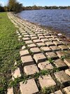
I was the project manager for our office when we designed the Brooklawn shoreline stabilization at the end of Timber Boulevard on Big Timber Creek circa 2010. The product we specified is called Cable Concrete and it is made by Bethlehem Precast. It is the most commonly specified product in our area. I suppose Chicklets is an appropriate nickname.


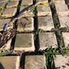
The mats come in 16' x 4' sections and all of the individual blocks are linked with cast in place 5/32" 302 stainless cable. We specified CC-45 which is built with the 45 lb individual blocks. In my discussions with the Army Corps, NJDEP and Bethlehem, they all agreed that the CC-45 was heavy enough for this application given the strong northwest winds coming off the Delaware and the fairly significant tidal range and summer boat traffic. There is only one heavier CC-70 for use where wave action is an issue.

Spec sheet: https://bethlehemprecast.com/wp-content/uploads/2015/08/Cable-Concrete-Specifications.pdf

The prep for the job was the biggest task. The shoreline was covered with more than 100 years' worth of rubble consisting of concrete slabs, asphalt, trees, old pilings and every kind of flotsam and jetsam you could imagine. We wrote into the bid specs that the contractor had to set up a crushing plant onsite and recycle as much concrete as possible and to use it as sub-base for the mats. He brought in a large Cat excavator to rip everything from the banks and fitted the excavator with a breaker to break the slabs and separate the rebar. Some of the rebar was #12 bar which is 12-8ths or 1-1/2" thick. It was brutal work but he did it very efficiently and with a smile on his face. He worked alone most of the time with his dog by his side every day.

We had to hire an archaeologist to review the site and its history before bidding and they found remains of pottery that they linked to an old tavern that was formerly located on the top of the bank. Typical for NJ, there was no funding for any further investigative work or preservation and all we had to do was include an area of additional 18" of fill over the guesstimated area where the tavern might have been. George Washington might have been under there but we shall never know. :)

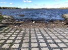
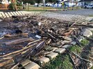
The Cable Concrete has been in the ground for 11 years now and every time I'm in town I stop to check it and nothing has moved. The cable is still as shiny as the day it was laid. It is intended to catch windblown soil and sediments from tidal deposition and naturally vegetate over time. We formed a contiguous boat ramp with the mats which has held up very well but it is the most effective trash collector you have ever seen after a hard northwest blow. That day the boat ramp was a disaster area. Sadly, there is usually drug paraphernalia in the debris the that blows in from Philadelphia's storm sewer systems.

The pics below were taken on November 1, 2021 when I was in town and it was actually during a good blow. Look at that boat ramp !!
 

Attachments

  • IMG_8915.jpg
    IMG_8915.jpg
    123.1 KB · Views: 135
  • IMG_8916.jpg
    IMG_8916.jpg
    141.5 KB · Views: 125
  • IMG_8917.jpg
    IMG_8917.jpg
    132.9 KB · Views: 146
  • IMG_8920.jpg
    IMG_8920.jpg
    164 KB · Views: 133

Teegate

Administrator
Site Administrator
Sep 17, 2002
25,951
8,694
I went down 70 again today and the second location is on the property next to what now is Carter Lumber if they are even open anymore. It was Dubell.


They put up a guard rail yesterday at the WaWa to protect whatever they are placing there. I guess they have worries at that intersection of cars getting into accidents and going off the road into it.
 

bobpbx

Piney
Staff member
Oct 25, 2002
14,659
4,837
Pines; Bamber area
I went down 70 again today and the second location is on the property next to what now is Carter Lumber if they are even open anymore. It was Dubell.


They put up a guard rail yesterday at the WaWa to protect whatever they are placing there. I guess they have worries at that intersection of cars getting into accidents and going off the road into it.
Guy, did you realize that in your link, if you zoom in, it's like Birdsye? Very clear.
 

Boyd

Administrator
Staff member
Site Administrator
Jul 31, 2004
9,826
3,005
Ben's Branch, Stephen Creek
Kind of weird, when you zoom past level 17 it changes to 45-degree imagery at very high resolution (maybe 3"/pixel?). If you switch to Birdseye view, there's a clearly visible shadow of the Google Car with the camera mast on top.
 

bobpbx

Piney
Staff member
Oct 25, 2002
14,659
4,837
Pines; Bamber area
Kind of weird, when you zoom past level 17 it changes to 45-degree imagery at very high resolution (maybe 3"/pixel?). If you switch to Birdseye view, there's a clearly visible shadow of the Google Car with the camera mast on top.
Google car? There is a tile tile here to change the plane, and when it does the cars are different, so the time period is different, especially when it's noted the bushes have suddenly got leaves.

1639946924672.png
 

Boyd

Administrator
Staff member
Site Administrator
Jul 31, 2004
9,826
3,005
Ben's Branch, Stephen Creek
Google car?

Click on Guy's link, zoom all the way in and then drag the little man to the map. Look around and you will see the shadow of the Google Maps car on the pavement. They have a mast on the roof with a 360-degree camera that photographs everything for street view.

Screen Shot 2021-12-19 at 4.37.33 PM.png
 

bobpbx

Piney
Staff member
Oct 25, 2002
14,659
4,837
Pines; Bamber area
Oh yes, I thought you were still looking in aerial view. I do street view a lot and drive on the street to look around. This morning I was driving on the main road in Greenwich NJ. Very historic town. A little while ago I was driving along streets in Yellowknife, NW territories.
 
  • Like
Reactions: Menantico

Boyd

Administrator
Staff member
Site Administrator
Jul 31, 2004
9,826
3,005
Ben's Branch, Stephen Creek
Sorry, I said "Birdseye View" but later realized Google calls it "Street View". I spend very little time on Google maps. They are watching whatever you look at and building a digital "voodoo doll" of you for their advertising business. Even if you are anonymous, they still build a voodoo doll to represent somebody "like you" to help them understand what a such a person is interested in.
 
Top