Snow

46er

Piney
Mar 24, 2004
8,837
2,143
Coastal NJ
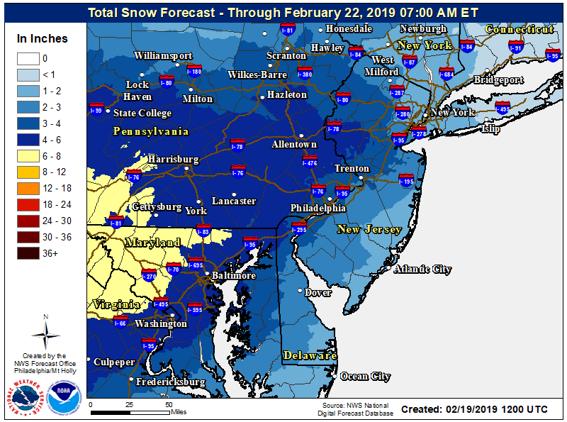
Perhaps some nasty stuff on the way tonight and again Monday night.

000
WWUS41 KPHI 100836
WSWPHI

URGENT - WINTER WEATHER MESSAGE
National Weather Service Mount Holly NJ
336 AM EST Sun Feb 10 2019

DEZ001-002-MDZ008-012-015-NJZ016>027-PAZ070-071-101-102-104-106-
102200-
/O.NEW.KPHI.WW.Y.0008.190211T0300Z-190211T1700Z/
New Castle-Kent-Cecil-Kent MD-Queen Annes-Salem-Gloucester-Camden-
Northwestern Burlington-Ocean-Cumberland-Atlantic-Cape May-
Atlantic Coastal Cape May-Coastal Atlantic-Coastal Ocean-
Southeastern Burlington-Delaware-Philadelphia-Western Chester-
Eastern Chester-Eastern Montgomery-Lower Bucks-
Including the cities of Wilmington, Dover, Elkton, Chestertown,
Centreville, Pennsville, Glassboro, Camden, Cherry Hill,
Moorestown, Mount Holly, Jackson, Millville, Hammonton,
Cape May Court House, Ocean City, Atlantic City,
Long Beach Island, Wharton State Forest, Media, Philadelphia,
Honey Brook, Oxford, West Chester, Kennett Square, Norristown,
Lansdale, Morrisville, and Doylestown
336 AM EST Sun Feb 10 2019

...WINTER WEATHER ADVISORY IN EFFECT FROM 10 PM THIS EVENING TO
NOON EST MONDAY...

* WHAT...Mixed precipitation expected. Total snow accumulations up
to two inches expected and ice accumulations of a light glaze
possible. Precipitation is expected to be mainly snow north of
Delmarva but may be mixed with sleet and freezing rain farther
south. Locally higher amounts of snow are possible, especially
if little mixing occurs.

* WHERE...Portions of southern New Jersey, southeast
Pennsylvania, northeast Maryland, and central and northern
Delaware.

* WHEN...From 10 PM this evening to noon EST Monday.

* ADDITIONAL DETAILS...Plan on slippery road conditions. The
hazardous conditions will likely impact the Monday morning
commute.

PRECAUTIONARY/PREPAREDNESS ACTIONS...

A Winter Weather Advisory means that periods of snow, sleet or
freezing rain will cause travel difficulties. Expect slippery
roads and limited visibilities, and use caution while driving.

The latest road conditions for the state you are calling from can
be obtained by calling 5 1 1.

&&

$$

For more information from the National Weather Service visit
www.weather.gov/phi/winter

CMS/Davis
StormTotalSnowWeb.png


StormTotalIceFcst.png
 
Last edited:

Boyd

Administrator
Staff member
Site Administrator
Jul 31, 2004
9,502
2,765
Ben's Branch, Stephen Creek
We got two to three inches of wet, heavy snow here. Flurries now but the forecast says up to 2 inches more could come down, so this one is heavier than yesterday's estimates. 48 degrees tomorrow and it will all be gone. :)
 

Boyd

Administrator
Staff member
Site Administrator
Jul 31, 2004
9,502
2,765
Ben's Branch, Stephen Creek
URGENT - WINTER WEATHER MESSAGE
National Weather Service Mount Holly NJ
332 AM EST Tue Feb 12 2019

DEZ001-MDZ008-012-NJZ016>022-025>027-122300-
/O.CON.KPHI.WW.Y.0009.000000T0000Z-190212T2300Z/
New Castle-Cecil-Kent MD-Salem-Gloucester-Camden-
Northwestern Burlington-Ocean-Cumberland-Atlantic-
Coastal Atlantic-Coastal Ocean-Southeastern Burlington-
Including the cities of Wilmington, Elkton, Chestertown,
Pennsville, Glassboro, Camden, Cherry Hill, Moorestown,
Mount Holly, Jackson, Millville, Hammonton, Atlantic City,
Long Beach Island, and Wharton State Forest
332 AM EST Tue Feb 12 2019

...WINTER WEATHER ADVISORY REMAINS IN EFFECT UNTIL 6 PM EST THIS
EVENING...

* WHAT...Mixed precipitation. Additional snow accumulations of
up to two inches and ice accumulations of a light glaze.

* WHERE...Portions of southern New Jersey, northeast Maryland
and northern Delaware.

* WHEN...Until 6 PM EST this evening.

* ADDITIONAL DETAILS...Plan on slippery road conditions. The
hazardous conditions could impact the morning commute.
 

Boyd

Administrator
Staff member
Site Administrator
Jul 31, 2004
9,502
2,765
Ben's Branch, Stephen Creek
Hazardous Weather Outlook
National Weather Service Mount Holly NJ
926 AM EST Mon Feb 18 2019

This Hazardous Weather Outlook is for central Delaware, southern
Delaware, central New Jersey, northern New Jersey and southern New
Jersey.

.DAYS TWO THROUGH SEVEN...Tuesday through Sunday.

A storm system will affect the area Wednesday through Thursday
morning. Snow on Wednesday will become a wintry mix, eventually
becoming all rain by Wednesday night. Hazardous driving conditions
are possible.

Screen Shot 2019-02-18 at 1.58.52 PM.png
 

Boyd

Administrator
Staff member
Site Administrator
Jul 31, 2004
9,502
2,765
Ben's Branch, Stephen Creek
WTF? I refreshed my browser multiple times and tried that link on both my PC and Mac. The "current briefing" is dated Monday, February 11 and describes last week's event on Tuesday February 12.

Screen Shot 2019-02-19 at 10.53.19 AM.png


The real storm is coming tomorrow, Wednesday February 20:

Tonight
Mostly cloudy, with a low around 25. North wind 3 to 5 mph.

Wednesday
Snow before 1pm, then rain and snow. High near 38. Calm wind becoming east 5 to 9 mph in the morning. Chance of precipitation is 90%. New snow accumulation of 1 to 3 inches possible.

Wednesday Night
Rain. Low around 37. East wind 8 to 11 mph becoming south after midnight. Chance of precipitation is 90%. New precipitation amounts between a half and three quarters of an inch possible.
 

Boyd

Administrator
Staff member
Site Administrator
Jul 31, 2004
9,502
2,765
Ben's Branch, Stephen Creek
A little more snow coming to the Southern Pines, they were spraying the roads this morning. Not much hope for an early spring in the 10 day forecast, just more of the same with highs in the 40's and lows in the 30's.

south.png
 

Boyd

Administrator
Staff member
Site Administrator
Jul 31, 2004
9,502
2,765
Ben's Branch, Stephen Creek
just more of the same with highs in the 40's and lows in the 30's.

Now they say it will be actually getting colder, with lows in the teens and highs in the 30's. And the accumulating snow has expanded to the North.

Screen Shot 2019-02-28 at 6.48.08 PM.png


URGENT - WINTER WEATHER MESSAGE
National Weather Service Mount Holly NJ
250 PM EST Thu Feb 28 2019

NJZ016>019-021-PAZ070-071-101-102-104-106-010800-
/O.NEW.KPHI.WW.Y.0013.190301T0600Z-190301T1500Z/
Salem-Gloucester-Camden-Northwestern Burlington-Cumberland-
Delaware-Philadelphia-Western Chester-Eastern Chester-
Eastern Montgomery-Lower Bucks-
Including the cities of Pennsville, Glassboro, Camden,
Cherry Hill, Moorestown, Mount Holly, Millville, Media,
Philadelphia, Honey Brook, Oxford, West Chester, Kennett Square,
Norristown, Lansdale, Morrisville, and Doylestown
250 PM EST Thu Feb 28 2019

...WINTER WEATHER ADVISORY IN EFFECT FROM 1 AM TO 10 AM EST
FRIDAY...

* WHAT...Snow expected. Total snow accumulations of 1 to 3
inches expected.

* WHERE...Portions of southern New Jersey and southeast
Pennsylvania.

* WHEN...Snow will begin overnight after midnight from west to
east and continue through early Friday morning before
diminishing to light rain or patchy freezing drizzle by late
morning. The heaviest snow is expected from roughly 4 AM to 8
AM
 

Boyd

Administrator
Staff member
Site Administrator
Jul 31, 2004
9,502
2,765
Ben's Branch, Stephen Creek
About two inches here, looks like it is moving out on the radar. But there is supposed to be more fun on the way, with some significant rain tonight.

Tonight
Rain. Low around 35. Northeast wind 11 to 13 mph. Chance of precipitation is 80%. New precipitation amounts between a half and three quarters of an inch possible.
 
Last edited:

Boyd

Administrator
Staff member
Site Administrator
Jul 31, 2004
9,502
2,765
Ben's Branch, Stephen Creek
Wow. When I went to bed last night they were forecasting a half inch of snow today. Now it looks like it could be one of our heavier storms of the season. :confused:

Right now it looks like I won't get too much here in Atlantic County, but as we have seen with other storms, the line where the heavy snow falls can change. The Northern parts of the pines could get hit pretty hard.

And then get ready for another deep-freeze, with a low temperature of only 10 degrees Wednesday night. I am getting really tired of this winter, am on track to use even more firewood than last year (which I thought was bad).

Screen Shot 2019-03-03 at 6.46.35 AM.png


Winter Storm Warning
URGENT - WINTER WEATHER MESSAGE
National Weather Service Mount Holly NJ
401 AM EST Sun Mar 3 2019

New Castle-Cecil-Western Monmouth-Eastern Monmouth-Salem-
Gloucester-Camden-Northwestern Burlington-Ocean-
Southeastern Burlington-Delaware-Philadelphia-
Including the cities of Wilmington, Elkton, Freehold, Sandy Hook,
Pennsville, Glassboro, Camden, Cherry Hill, Moorestown,
Mount Holly, Jackson, Wharton State Forest, Media,
and Philadelphia
401 AM EST Sun Mar 3 2019

...WINTER STORM WARNING IN EFFECT FROM 3 PM THIS AFTERNOON TO
7 AM EST MONDAY...

* WHAT...Heavy wet snow and sleet expected. Total snow and sleet
accumulations of 4 to 7 inches expected.

* WHERE...Portions of central and southern New Jersey, southeast
Pennsylvania, northeast Maryland and northern Delaware.

* WHEN...Rain and snow develops this afternoon, then all snow
occurs into this evening. Snow should mix with sleet from
southeast to northwest by later this evening, with even some
areas changing to rain especially closer to the coast. Any rain
or wintry mix changes back to snow before ending early Monday
morning.


* ADDITIONAL DETAILS...Travel could be very difficult. Snowfall
rates of up to an inch per hour will be possible between about 5
PM and 11 PM, especially closer to Interstate 95. While the
precipitation will end before the Monday morning commute,
hazardous conditions should still be occurring from the earlier
heavy wet snow and sleet.
 
Last edited:
Top