Greetings! 
The PBX crew performed one of our explorations yesterday. The trip was designed by Guy and was conducted deep in the woods near the Forked River Mountains.
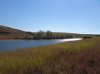
This land is a mixture of high uplands interspersed with the ravines of several headwaters of the Forked River and Oyster Creek. The Cave Cabin Branch and Long Branch both run to the North Branch of the Forked River, while Cold Spring Branch runs to the Oyster Creek.
We had a plan. We were looking for the fabled black hamlet deep in these woods. We also wanted to hit some high spots, including 2 hills (1 as high as Forked River Mountain) as well as a visit to Chicken Bone ridge, which is a dividing ridge between the Forked River and Oyster Creek. Our final destination was the long-abandoned Albert Brothers Home-place, where many fox hunts began and many an evening was spent pickin and plucking on banjos.
This trip was strenuous. It ended up being 6.4 miles of grueling, difficult hiking through very dense huckleberry. I was amazed at the dense vegetation, even if it has been 18 years since the big fire of '95. The huckleberry were like constant straggly fingers trying to slow you down and trip you up. This trip, in all seriousness, was 85% difficult, 5% very difficult, 5% virtually impassable without a struggle, and 5% fairly easy going. We were in stuff so thick that a big buck refused to move himself until Chris (Hewey) stopped right next to it.
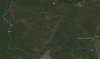
Here is the plan, and right below it the tracks from yesterday. The tracks were supplied by Guy. Also some photos to enjoy.
There were not a lot of photos because of the dense woods. We were in many desolate locations. The one hill we were on was marked 184 on the map, but my altimeter read 190 feet. These hills were not visited by off-road vehicles, which is very rare in the pines. Nor were there paths leading up them. The feeling of wild country was great, which is why I gave it a 9 out of 10. I love those wild spots. But overall the crew gave it a 7.9. It was a difficult slog.


The PBX crew performed one of our explorations yesterday. The trip was designed by Guy and was conducted deep in the woods near the Forked River Mountains.
This land is a mixture of high uplands interspersed with the ravines of several headwaters of the Forked River and Oyster Creek. The Cave Cabin Branch and Long Branch both run to the North Branch of the Forked River, while Cold Spring Branch runs to the Oyster Creek.
We had a plan. We were looking for the fabled black hamlet deep in these woods. We also wanted to hit some high spots, including 2 hills (1 as high as Forked River Mountain) as well as a visit to Chicken Bone ridge, which is a dividing ridge between the Forked River and Oyster Creek. Our final destination was the long-abandoned Albert Brothers Home-place, where many fox hunts began and many an evening was spent pickin and plucking on banjos.
This trip was strenuous. It ended up being 6.4 miles of grueling, difficult hiking through very dense huckleberry. I was amazed at the dense vegetation, even if it has been 18 years since the big fire of '95. The huckleberry were like constant straggly fingers trying to slow you down and trip you up. This trip, in all seriousness, was 85% difficult, 5% very difficult, 5% virtually impassable without a struggle, and 5% fairly easy going. We were in stuff so thick that a big buck refused to move himself until Chris (Hewey) stopped right next to it.
Here is the plan, and right below it the tracks from yesterday. The tracks were supplied by Guy. Also some photos to enjoy.
There were not a lot of photos because of the dense woods. We were in many desolate locations. The one hill we were on was marked 184 on the map, but my altimeter read 190 feet. These hills were not visited by off-road vehicles, which is very rare in the pines. Nor were there paths leading up them. The feeling of wild country was great, which is why I gave it a 9 out of 10. I love those wild spots. But overall the crew gave it a 7.9. It was a difficult slog.