I found myself in Greenwich with a couple of hours with nothing to do this Sunday so brought my running shoes. Looking on the map for a destination the night before I saw Tindall (aka Tyndall Island) Island Trail. Searching for more info I came across a most excellent 2010 trip report and thread right here on NJPineBarrens. Going in I knew the trail's causeway had a major breach that was only accessible at the lowest of tides and assumed the fun part of the run would be passing all of Greenwich's old houses (which were particularly resplendent in the fall foliage).
I was surprised then to get to the breach and find the water low and easily crossable. I pulled up the tide charts and realized that dumb luck had brought me an hour before low tide, giving me plenty of time to explore without having to worry about getting stuck wading through rising water as some people on the 2010 thread reported.
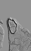
So I hopped the breach and continued on the causeway. Before too long I got to the monument people mentioned in 2010, right before you get to the three Tindall Islands. I went straight ahead to the southern-most island. It took me awhile to figure it out. I should have just checked the 2021 B/W Lidar on Boydsmaps:
This island has a ten-foot-or-so berm about four feet high on top that circles around the edge of the whole southern island. Looking at the aerial maps it shows up sometime between 1980 and 1995 and had water within in. At the top end of the island there's some sort of metal contraption with what looks like drains below it. I have no idea why someone would have build this berm and water control structure at this time. The trees growing on top make it hard to walk there but there are spots in which you can walk along the bottom of the berm. At the far end of the island are shells, some cool bones, and various evidence of animals, including the large piles of scat mentioned in the 2010 post.
Near the water control structure I saw what kind of worked as a path to the next island. It was a six inch gap in the phragmites, obviously only semi-dry at low tide. There were deer prints so I knew I wasn't the first going through.
It's a bit of an adventure to push past the reeds and not get too muddy. The maps show a road between these islands but I saw no evidence.I walked to the next island (which I marked as the middle island) and then mud-walked again to the third island. I didn't explore it too much, which I kind of regret as the 2010 folks said there are some cellar holes back there.
Here's a Google Photos link to more photos: https://photos.app.goo.gl/ghp9SS8H8RRjvA4n8
Also, on your way back out of Greenwich, if the Museum of Prehistory is open definitely make a point of stopping. It's very cool and the staffers really know their archaeology.
I was surprised then to get to the breach and find the water low and easily crossable. I pulled up the tide charts and realized that dumb luck had brought me an hour before low tide, giving me plenty of time to explore without having to worry about getting stuck wading through rising water as some people on the 2010 thread reported.
So I hopped the breach and continued on the causeway. Before too long I got to the monument people mentioned in 2010, right before you get to the three Tindall Islands. I went straight ahead to the southern-most island. It took me awhile to figure it out. I should have just checked the 2021 B/W Lidar on Boydsmaps:
This island has a ten-foot-or-so berm about four feet high on top that circles around the edge of the whole southern island. Looking at the aerial maps it shows up sometime between 1980 and 1995 and had water within in. At the top end of the island there's some sort of metal contraption with what looks like drains below it. I have no idea why someone would have build this berm and water control structure at this time. The trees growing on top make it hard to walk there but there are spots in which you can walk along the bottom of the berm. At the far end of the island are shells, some cool bones, and various evidence of animals, including the large piles of scat mentioned in the 2010 post.
Near the water control structure I saw what kind of worked as a path to the next island. It was a six inch gap in the phragmites, obviously only semi-dry at low tide. There were deer prints so I knew I wasn't the first going through.
It's a bit of an adventure to push past the reeds and not get too muddy. The maps show a road between these islands but I saw no evidence.I walked to the next island (which I marked as the middle island) and then mud-walked again to the third island. I didn't explore it too much, which I kind of regret as the 2010 folks said there are some cellar holes back there.
Here's a Google Photos link to more photos: https://photos.app.goo.gl/ghp9SS8H8RRjvA4n8
Also, on your way back out of Greenwich, if the Museum of Prehistory is open definitely make a point of stopping. It's very cool and the staffers really know their archaeology.