
On Oct 17, 2012 I kayaked to Oak Island and toured the place as best I could. Hiking the island is no picnic becuse of the dense tangle of briers and other plants that reach waste high and higher in some places. On Oct 18, 2012 I hiked toward the island from the old roadway off Rt 9. As a condition of my special use permit, I need to provide US FWS a report and a copy of my pictures. Here are some of the pictures that I took.
 (2).jpg")
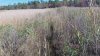
Point of departure on Bass River. Cross the river, enter Broadhead Creek and take the first tributary on your left. This will bring you to the southern most part of the island
 (2).jpg")
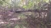
The oyster dredge is still at my landing point. There is a clearing for about a 10 yard radius around this spot. After that, the briers and undergrowth for about 75 yards make travel impossible. I had to go along a deer path in the marsh to travel any further. After the 75 yards, there is higher ground with almost no undergrowth and you come to the 1935 geodetic survey monuments.......
.jpg")
This is the triangulation station disk. The fiberglass witness post is still present (top of picture) but broken off.
.jpg")
Below is the reference mark disk NO. 2
.jpg")
There should be another reference mark disk labeled NO. 1 but it is missing! In it's place where it should have been I found a square hole. Since USGS last inspected these markers in 2011, it was removed recently. The markers are in line with each other approximately 15 feet apart.
The triangle disk N 39 34.5130 W 074 26.3219 elevation approx 12 feet.
.jpg")
Missing marker?
.jpg")
Ruins of a structure I believe was used by the USGS folks. Inside is a collapsed block chimney with a hole in the block for a stove pipe. N 39 34.6344 W 074 26.5192
.jpg")
This I believe is a fox den hole judging by the number and type of tracks around it. It was about 50 feet from the ruins described above
.jpg")
Duck pond on the eastern side of the island. I saw two duck blinds on the pond but no ducks.
N 39 34.5308 W 074 26.1924
.jpg")
Tree stand not far from the duck pond. It's chained to the tree and there are no steps going up to it. US FWS probably has rules against putting nails in trees.
Up to this point I could find no evidence of man made trails, but the hiking was easy due to the lack of undergrowth. As I continued north I found a raised trail and followed it a short distance but this area was heavily encased in dense briers. I could see where it made a sharp 90 degree turn toward the east, eventually curving around toward rt 9. There is a low area just before this trail which is full of tall Spartina grass and briers that I couldn't wade through. I was disappointed because this is supposedly the area where there are several ruins of homesteads. A better approach would be to come in via boat from Jobs Creek and Rt 9.
Point of departure on Bass River. Cross the river, enter Broadhead Creek and take the first tributary on your left. This will bring you to the southern most part of the island
The oyster dredge is still at my landing point. There is a clearing for about a 10 yard radius around this spot. After that, the briers and undergrowth for about 75 yards make travel impossible. I had to go along a deer path in the marsh to travel any further. After the 75 yards, there is higher ground with almost no undergrowth and you come to the 1935 geodetic survey monuments.......
This is the triangulation station disk. The fiberglass witness post is still present (top of picture) but broken off.
Below is the reference mark disk NO. 2
There should be another reference mark disk labeled NO. 1 but it is missing! In it's place where it should have been I found a square hole. Since USGS last inspected these markers in 2011, it was removed recently. The markers are in line with each other approximately 15 feet apart.
The triangle disk N 39 34.5130 W 074 26.3219 elevation approx 12 feet.
Missing marker?
Ruins of a structure I believe was used by the USGS folks. Inside is a collapsed block chimney with a hole in the block for a stove pipe. N 39 34.6344 W 074 26.5192
This I believe is a fox den hole judging by the number and type of tracks around it. It was about 50 feet from the ruins described above
Duck pond on the eastern side of the island. I saw two duck blinds on the pond but no ducks.
N 39 34.5308 W 074 26.1924
Tree stand not far from the duck pond. It's chained to the tree and there are no steps going up to it. US FWS probably has rules against putting nails in trees.
Up to this point I could find no evidence of man made trails, but the hiking was easy due to the lack of undergrowth. As I continued north I found a raised trail and followed it a short distance but this area was heavily encased in dense briers. I could see where it made a sharp 90 degree turn toward the east, eventually curving around toward rt 9. There is a low area just before this trail which is full of tall Spartina grass and briers that I couldn't wade through. I was disappointed because this is supposedly the area where there are several ruins of homesteads. A better approach would be to come in via boat from Jobs Creek and Rt 9.

")