
Has anyone been back there recently?
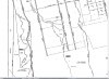
Currently the only access to West Mill Road is from Route 206. The other access point is from Route 542 (by the Church in Pleasant Mills). Access from Route 542 is currently closed because the bridge by the Church in Pleasant Mills is unsafe to cross.
I've been going back West Mill Road (from Route 206) for the last 25 years. I mainly go back there to deer hunt and hike. The road was sometimes not that easy to navigate in those 25 years. Especially the section closest to Route 206. The Forest Fire Service fixed the entire length of the road 3 years ago (Fall 2012). It was nice after they fixed it and I no longer had to worry about damaging my vehicle.
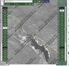
The portion of road that sits northeast of Paradise Lakes is now flooded. It has been flooded since early October. 1 mile portion of the road is underwater and now is impassable. The woods surrounding the road is flooded and water is flowing across/down the road. I thought beavers created this problem but I looked around and didn't see any evidence to support my thinking.
Paradise Lakes was recently purchased and has a new owner. I know a new dam was constructed at Paradise Lakes after the purchase. I'm thinking maybe the owner raised the level of the water at Paradise Lakes (by raising the dam) thus flooding the woods that sit northeast of Paradise Lakes? I don't plan to walk over there to check out the dam because the area is clearly marked with 'No Trespassing' signs.
Anybody have any ideas who I should contact regarding this situation?
Thanks!
Currently the only access to West Mill Road is from Route 206. The other access point is from Route 542 (by the Church in Pleasant Mills). Access from Route 542 is currently closed because the bridge by the Church in Pleasant Mills is unsafe to cross.
I've been going back West Mill Road (from Route 206) for the last 25 years. I mainly go back there to deer hunt and hike. The road was sometimes not that easy to navigate in those 25 years. Especially the section closest to Route 206. The Forest Fire Service fixed the entire length of the road 3 years ago (Fall 2012). It was nice after they fixed it and I no longer had to worry about damaging my vehicle.
The portion of road that sits northeast of Paradise Lakes is now flooded. It has been flooded since early October. 1 mile portion of the road is underwater and now is impassable. The woods surrounding the road is flooded and water is flowing across/down the road. I thought beavers created this problem but I looked around and didn't see any evidence to support my thinking.
Paradise Lakes was recently purchased and has a new owner. I know a new dam was constructed at Paradise Lakes after the purchase. I'm thinking maybe the owner raised the level of the water at Paradise Lakes (by raising the dam) thus flooding the woods that sit northeast of Paradise Lakes? I don't plan to walk over there to check out the dam because the area is clearly marked with 'No Trespassing' signs.
Anybody have any ideas who I should contact regarding this situation?
Thanks!
Last edited:


") , on existing roads, the pushed portion would be treated as public too.
, on existing roads, the pushed portion would be treated as public too.
