Wharton Boundary

PinesExplr

Scout
Dec 7, 2005
94
9
Medford, NJ
Does anyone know the latest boundary of Wharton (State Forest) in the area between Jackson/Medford Rd and Hopewell Rd? I thought I noticed a new sign off Hopewell Rd just south of Stone Mtn (Little Mill CC) that looked like a State Forest Boundary sign.

If thats Wharton, does it link to the larger forest in the area of the wildlife refuge/west jersey cranberry bogs? Wharton SF in Marlton?

I also noticed a sign near Crowfoot Rd road for "Rancocas Conservancy".

Thks
 

Teegate

Administrator
Site Administrator
Sep 17, 2002
25,642
8,250
I can't help you if it is new acquisitions. Wharton never made it to Marlton; however, it now may since they just add the property they acquire to the main state forest that is near it. You should go to the local clerks office of Marlton and Medford and ask about all that property near your house. I bet you can find quite a bit of interesting info. The one problem would be if you want older info. I went to Marlton and they do not keep anything there that is "old." They told me when I went there they ship it to the county. They don't have the room in that massive building to store it.


Guy
 

Boyd

Administrator
Staff member
Site Administrator
Jul 31, 2004
9,547
2,806
Ben's Branch, Stephen Creek
FWIW, if you download either the classic or nuvi version of my Map of the Pines, you will see the boundaries of Wharton and all the other State properties on your Garmin GPS. Well, anyway... as best as I could do with the data available on the State's GIS website. I don't know how often they update those files or how accurate they are, but I used data which was available about 6 months ago.

See: http://forums.njpinebarrens.com/showthread.php?t=5929
 

Boyd

Administrator
Staff member
Site Administrator
Jul 31, 2004
9,547
2,806
Ben's Branch, Stephen Creek
Just opened up my source file in Global Mapper and had it fill all of the Wharton areas with green. I have removed a lot of other details from the map to make it more readable. According to my data, this is the extent of Wharton properties in (I think) the area you mention.

wharton01.jpg


As I said, this is based on data downloaded from NJGS about 6 months ago...
 

Boyd

Administrator
Staff member
Site Administrator
Jul 31, 2004
9,547
2,806
Ben's Branch, Stephen Creek
Here's the metadata associated with the files. It's about 5 years old (December 2004)

Originator: New Jersey Department of Environmental Protection (NJDEP), Green Acres
Publication_Date: 1995
Title: NJDEP State Owned, Protected Open Space and Recreation Areas in New Jersey
Edition: 2005
Geospatial_Data_Presentation_Form: vector digital data
Publication_Information:
Publication_Place: Trenton, NJ
Publisher: Green Acres

Other_Citation_Details: This version is current to the end of 200412.
Online_Linkage: <http://www.state.nj.us/dep/gis/digidownload/zips/statewide/newstate.zip>

Description:

Abstract:
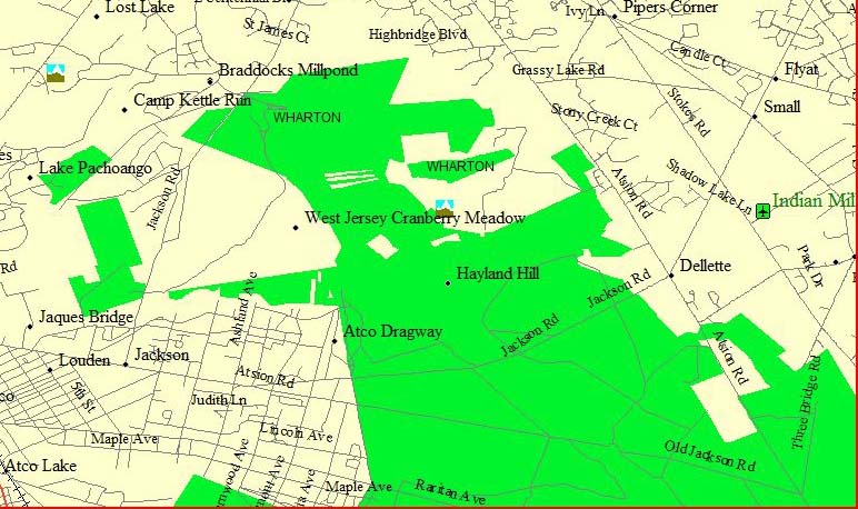
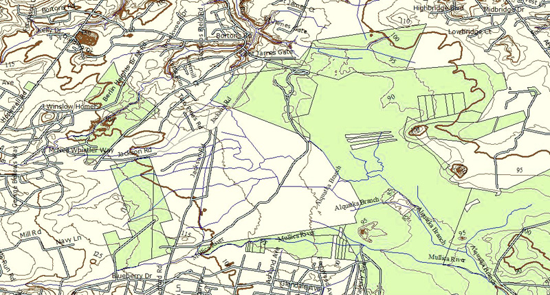
This data set contains protected open space and recreation areas owned in fee simple interest by the State of New Jersey Department of Environmental Protection (NJDEP). Types of property in this data layer include parcels such as parks, forests, historic sites, natural areas and wildlife management areas. The data was derived from a variety of source maps including tax maps, surveys and even hand-drafted boundary lines on USGS topographic maps. These source materials vary in scale and level of accuracy. Due to the varied mapped sources and methods of data capture, this data set is limited in its ability to portray all open space lands accurately, particularly the parcels purchased prior to 1991.

Purpose:
To provide Natural and Historic Resource Divisions in NJDEP with a manageable, graphic inventory of state owned and protected open space throughout New Jersey. It serves as a valuable tool in land acquisition decisions and is NOT to be used for describing actual or true property ownership title.

Supplemental_Information:
A detailed discussion of specific procedures used to create and update this inventory of state owned and protected open space is included in the Mapping_Methodology.doc contained in the downloadable ZIP file. Please read it prior to using the data set to better understand limitations and intended use.
 

Boyd

Administrator
Staff member
Site Administrator
Jul 31, 2004
9,547
2,806
Ben's Branch, Stephen Creek
Well I just downloaded the latest. According to the metadata it is current as of December 10, 2008. Go figure... Notice the little "island" in the Northwest corner by Hopewell Rd :).

wharton02.jpg
 

PinesExplr

Scout
Dec 7, 2005
94
9
Medford, NJ
ah, new info to me

The "island" on Hopewell you note is on the opposite side of the sign I noticed - so that is Marlton, I believe.

The sign (actually there are about 4-5 five of them, one color SF sign, the rest the B&W "rules" signs I see a lot) were 1/2 between LMCC & the island, on the opposite side (as seen on your map). I don't see that stretch on the maps, so maybe its a very recent addition. I drive that stretch 2-4x a day and just noticed the signs about a week ago.

ed


Well I just downloaded the latest. According to the metadata it is current as of December 10, 2008. Go figure... Notice the little "island" in the Northwest corner by Hopewell Rd :).

wharton02.jpg
 

raiden098

New Member
Apr 27, 2005
25
0
Grinnell, IA
Those three little strips right above "Jersey" in West Jersey Cranberry Meadow are also owned by the state. You can see some of the stones in this thread from our PBX hike there.


http://forums.njpinebarrens.com/showthread.php?t=5166&highlight=alquatka


Guy

WOAH. One wonders how I let this one fly over my head. I live right on Gravelly for god's sake..
I remember heading through that area about this time last summer. The greenery was lovely but nothing short of a hazmat suit would have kept the flies from me. I'm going to try and hit the place up with some waders and a camera tomorrow.
 

Teegate

Administrator
Site Administrator
Sep 17, 2002
25,642
8,250
If you give the area you will be in I will pass along some cords if you want to do some stone searching. That is if you are in the area I have info on.

Guy
 
Top