I have a hypothesis, but want to hear from others first. Any ideas as to what these grid-like patterns are? These features predate the 1931 aerial photos.

What are these features?
- Thread starter pinelandpaddler
- Start date
You are using an out of date browser. It may not display this or other websites correctly.
You should upgrade or use an alternative browser.
You should upgrade or use an alternative browser.

There's something similar near Washington that I always found interesting.
https://boydsmaps.com/#17.00/39.682946/-74.573294/midatlidar/0.00/0.00
I wondered if it might have been caused by years of mowing/harvesting/tilling the soil but really don't know.
https://boydsmaps.com/#17.00/39.682946/-74.573294/midatlidar/0.00/0.00
I wondered if it might have been caused by years of mowing/harvesting/tilling the soil but really don't know.
I'd suggest blueberry as well, but they were traditionally grown in wetter soils, especially before modern advances in irrigation. Given the existence of the pit silo ruins nearby, I'd me more likley to go with an old cornfield.
Looking at agricultural areas on the LIDAR is pretty interesting, have not spent much time doing that. But looking quickly now, most of the farmland as well as the "alphabet soup" rye strips shows parallel lines from mowing/cultivation. You can see that here (near the Hammonton airport).
https://boydsmaps.com/#17.00/39.659693/-74.746706/midatlidar/0.00/0.00
But the field where the crosshairs are centered shows more of a grid pattern. Look back through the aerials and you will see it was once a field similar to the others but has gradually grown over. For example, look at the 1995 vs 2000 aerials. I'm wondering if that is actually a plantation/nursery? Would that result in a more grid-like pattern?
Are there examples of blueberry or corn fields that have a grid pattern vs parallel lines?
Two two locations I linked to are the only two that I've found that have this grid pattern.
I'm seeing it in overgrown areas bordering developments, for example
https://boydsmaps.com/#17.00/39.860319/-74.754612/midatlidar/0.00/0.00
https://boydsmaps.com/#17.00/39.860319/-74.754612/pines1995/0.00/0.00
Could this be the result of levelling an area with bulldozers or other heavy equipment? Maybe a tree farm or re-forestation project, where where they plant lots of little saplings in a grid pattern?
I think they're all over the place, if you look for them! ") This one is interesting, looking all the way back through the aerials, it just appears to be a wooded area. But on the 1930's aerials, it looks sort of like an old field.
This one is interesting, looking all the way back through the aerials, it just appears to be a wooded area. But on the 1930's aerials, it looks sort of like an old field.
https://boydsmaps.com/#17.00/39.595866/-74.780861/midatlidar/0.00/0.00

I'm thinking these are old tree farms/nurseries.
This one is interesting, looking all the way back through the aerials, it just appears to be a wooded area. But on the 1930's aerials, it looks sort of like an old field.https://boydsmaps.com/#17.00/39.595866/-74.780861/midatlidar/0.00/0.00
I'm thinking these are old tree farms/nurseries.
You are no doubt correct about this location. Here are some other examples: https://boydsmaps.com/#18.00/39.632185/-74.688277/midatlidar/0.00/0.00I think they're all over the place, if you look for them!
https://boydsmaps.com/#17.00/39.595866/-74.780861/midatlidar/0.00/0.00
View attachment 20689
I'm thinking these are old tree farms/nurseries.
Take a look at the 1977 aerials and it becomes obvious that these are tree nurseries. I'm not so sure about the locations I linked to in the OP. I should have said, "the two locations I linked to are the only two that I've found that have this specific grid-like pattern."
There are some differences that may or may not be significant. In the location above, note that the "modules" in the "grid" are significantly larger. Also note that much of this location was deforested in the 1931 aerial. By 1951, many trees had grown, but not in a way corresponding to the "grid."
What kind of trees were planted there?Would you consider this one? If so I know exactly what this field was.
I wouldn't classify this one with the features at Tulpehocken and Sweetwater.
Apple. Planted I believe in the 30’s or 40’s. Hasn’t been farmed since the 80’s or soWhat kind of trees were planted there?
I wouldn't classify this one with the features at Tulpehocken and Sweetwater.
I suspect the house for the farm at Hawkins Bridge is the large cellar hole right along the road at the top of the hill.
The features at Washington most likely is the Sooy properties N.P. Sooy, P.S. Sooy Job W. Sooy had three lots at 10.5177 acres, 15.6947 acres and 4.4115 acres.The property stones were still there when Wharton was purchased. I went there years ago after a very crispy fire where all you could see was dirt and I did not find the stones.
The features at Washington most likely is the Sooy properties N.P. Sooy, P.S. Sooy Job W. Sooy had three lots at 10.5177 acres, 15.6947 acres and 4.4115 acres.The property stones were still there when Wharton was purchased. I went there years ago after a very crispy fire where all you could see was dirt and I did not find the stones.
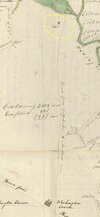
Guy, do you think the features I am looking at near Hawkin Bridge are remnants of the farm?I suspect the house for the farm at Hawkins Bridge is the large cellar hole right along the road at the top of the hill.
The features at Washington most likely is the Sooy properties N.P. Sooy, P.S. Sooy Job W. Sooy had three lots at 10.5177 acres, 15.6947 acres and 4.4115 acres.The property stones were still there when Wharton was purchased. I went there years ago after a very crispy fire where all you could see was dirt and I did not find the stones.
Guy, do you think the features I am looking at near Hawkin Bridge are remnants of the farm?
I have never heard anyone mention what the ruins were along the road south of Hawkin's bridge and I know there were other farms south of that location. I would think you are correct.
Did you notice a somewhat similar disturbance south of there at the Godfrey Estlow property?
@Boyd are these striations artifacts or are they really there? They don't show in the Mid-Atlantic Lidar
That's some kind of artifact, probably the result of the workflow I used when creating that map. That was one of my first 3d maps using the MapBox API and I didn't quite understand a couple of the finer points (you need to figure it all out for yourself, they don't support making you own maps with your own data).@Boyd are these striations artifacts or are they really there? They don't show in the Mid-Atlantic Lidar
If you want to see the most accurate representation, use the terrain viewer. It creates a new map from my improved dataset every time and you can further explore by changing the lighting and using 3d view. I don't see any grid patterns here.
https://boydsmaps.com/terra/#39.708.../-2000/1296/-2000/40.25/5/2d/shader10/0/0/z17
I like how the LIDAR proves the old cranberry bogs that were present near 100 years ago or more for example at Leamings Mill and Bennett’s Mill. At least that’s what I believe these lines to be?
This map shows a cabin in the vicinity of where Hawkin bridge would be I believe. I too have wondered what the cellar hole was. Lots of references to Tulpenhawkin (spelled in numerous variations) in old texts and deeds. References to a mill dating back to the 1700s, but information is few and far between.