That excerpt from Harshberger's book is very informative. I gotta get me a copy of that. Thanks for the maps, fellers. Makes fine sense to me.

What constitutes the Pine Barrens?
- Thread starter pinelandpaddler
- Start date
You are using an out of date browser. It may not display this or other websites correctly.
You should upgrade or use an alternative browser.
You should upgrade or use an alternative browser.
I keep coming back to this thread because the topic fascinates me for some reason. Here's another answer to your question.... go to the i-MapNJ site and launch the viewer:
http://www.nj.gov/dep/gis/depsplash.htm
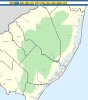
Notice on the left that there's a layer named "pinelands boundaries". I've attached a screengrab of what they consider to be the pinelands. BTW, that's a very cool website that I want to spend some time exploring...
http://www.nj.gov/dep/gis/depsplash.htm
Notice on the left that there's a layer named "pinelands boundaries". I've attached a screengrab of what they consider to be the pinelands. BTW, that's a very cool website that I want to spend some time exploring...
Attachments
Boyd, I have trouble with that site all the time. It does not do what you want it to. You select things like names and munipalities, hit refresh, and it does nothing. Do you have the same problem?
I really haven't spent any time there yet, just played around a for a few minutes. Last year ago I used a similar GIS browser for Atlantic County to determine where the flood plain was in relation to my home. Then last week I tried that site again and got nothing but errors.... weird.
Boyd, I have trouble with that site all the time. It does not do what you want it to. You select things like names and munipalities, hit refresh, and it does nothing. Do you have the same problem?
Bob
I use it all the time for work, almost daily.
Make sure you have all pop up blockers off or you will be booted out just as you are about to open a layer of data.
The Big News this month is that they have added a base mapping layer of 1930 aerials. You deselect the 2002 photobase when you have your area and select 1930 aerial and whallla!
It is cooller than hell and I have been playing with it all week.
Actually that can can contribute to blindness I am told.
")
Wow... that is really cool to see the way the area around my house looked almost 80 years ago! Thanks for the tip, but I fear I could also be afflicted by blindness soon as well
Bob, some of the layers appear to be 'greyed out' in my browser even though I can select them. These won't show when you refresh the image. Took me a few minutes to catch on, but the layer availability depends on what zoom level you're at. Try zooming in and out and you will notice layers changing between gray and dark blue. When they're dark blue you should be able to select and view them.
Bob, some of the layers appear to be 'greyed out' in my browser even though I can select them. These won't show when you refresh the image. Took me a few minutes to catch on, but the layer availability depends on what zoom level you're at. Try zooming in and out and you will notice layers changing between gray and dark blue. When they're dark blue you should be able to select and view them.
I did everything; changed my system to always accept pop-ups from that site, etc. Nothing. I am going to blame it on my video card.
Whoops, wait, I finally got it. You are right, I should have zoomed in more with a dab of patience........
Scott, thanks so much for the tip on the 1931 maps. It opens up an astounding new world for us to explore. GREAT!
This is a section close to Whiting. Guess what the dots are. I am positive I know what they are:

This is a section close to Whiting. Guess what the dots are. I am positive I know what they are:
Those are landing sites for alien spacecraft. They could be charcoal pits too, but I like the landing sites idea better.
Those are landing sites for alien spacecraft. They could be charcoal pits too, but I like the landing sites idea better.
Charcoal pits German? How deep might they be then?
Since we are talking about the work of NJ pine barrens colliers, they would be pits in name only, more accurately being desrcibed as mounds. After the charcoal is scooped up, I'd guess only a minor depression would be left if any.
I was thinking that also (charcoal pits) but they seemed too numerous. I wasn't sure of the distance/perspective of the photo either.
Jeff
Jeff
Scarlet snake
I read these old posts today and thought of the only time I've seen a scarlet snake in NJ. It was in a place that would not be considered it's habitat. It was on the marshes of the Delaware bay down from Stowsneck.ok, but i'll guarantee you a scarlet one way or the other
Stowsneck????? would you mean stow creek?Sayres neck??? never heard of stows neck and beings it's in my neck of the marsh that is upsetting
Al
Al
Stowneck rd. in Cumberland county. It ends at a little landing and parking area. Not sure if that has a name. It was 1985 so it's been a while.Stowsneck????? would you mean stow creek?Sayres neck??? never heard of stows neck and beings it's in my neck of the marsh that is upsetting
Al
Stow Neck Road runs the length of Stow Creek Neck, south off of Frog Ocean Road in Canton. Purty place.