I am deciding whether the National Geographic map or Mapsend software are good for the Wharton area. Has anyone used them?

What is a good Topo map for use on a Magellan Triton GPS?
- Thread starter Neil in SJ
- Start date
You are using an out of date browser. It may not display this or other websites correctly.
You should upgrade or use an alternative browser.
You should upgrade or use an alternative browser.
I have a Triton 1500 but have only used to to run my own alternative software and home-made maps. But the National Geographic maps look pretty nice from what I've read: http://maps.nationalgeographic.com/downloads/NG_Triton_Export_Guide_low.pdf
Or if you are really adventurous, have a good understanding of computers and like tinkering with things, you could run OziExplorer like I did on my Triton") . See this thread for more info: Just ordered a Triton 1500 - Magellan Handheld Forum
. See this thread for more info: Just ordered a Triton 1500 - Magellan Handheld Forum
This only works on the touchscreen models however (the 1500 and 2000)
Or if you are really adventurous, have a good understanding of computers and like tinkering with things, you could run OziExplorer like I did on my Triton
. See this thread for more info: Just ordered a Triton 1500 - Magellan Handheld ForumThis only works on the touchscreen models however (the 1500 and 2000)
Boyd
I have a triton 500 and use national geographic TOPO with it.the maps are great and can be used on the topo.the maps can be used on a laptop to track as you drive with a garmin but the update to do this with the triton is still in the making.
there has been some really trying issues with vanatge point and windows vista but they all seem to be ironed out now.the one down point for me is the smallness of the screen but the thing is very accurate,gets me within 10 ft of stones on a continual basis and they appears to be totally waterproof.once dropped mine into nescohague creek and couldn't find it for five minutes and when i brought it upand it was running.then later i dropped it in wv and broke the turn on button.i then found out that magellan will not fix your unit once it is off the warranty.I offered to pay to have it fixed and they will no way under any circumstances fix a triton off warranty so once it's off warranty wrap it in styrofoam or something because if you break it,it's dead.i had dropped it on other occasions before and it took it,the buttons are the weak spots and when it fell it hit a small protrusion on the rock i was on and snapped off the part attached to the board inside.
I think tritons are great but magellan has no support at all other then computer maggie and they are very unpersonable.on the other hand nat geo is very helpful and their support team is great.
Al
The Triton series really gets no love on the various GPS forums. I think the hardware is nice, based on my Triton 1500 and you seem to confirm this. They use the SiRFStar III chipset which is held in great reverence by many - same chips used in the older Garmin 60csx units (new 60csx units have the MTK chipset). But Magellan tech support gets poor marks from what I've read, and you are confirming this.
A great resource for the Triton is http://www.tritonforum.com. However, just now when I tried to access the site I got a message from my Trend Micro security software that the site was dangerous and is blocked. So I checked it out using my Mac, and evidently they were recently hacked but it's now been cleaned up. I posted a message over there about this, so hopefully the site admin will get it cleared up. There a lots of helpful people there and other good resources.
Having said all this, I would really suggest that anyone in the market for a GPS seriously consider the Garmin Oregon, Dakota or possibly Colorado series. They can use all the free maps available at GPSFileDepot.com as well as Garmin's own products. You can also make your own maps from anything you can download or scan: http://www.garmin.com/garmin/cms/site/us/onthetrail/custommaps and they are introducing a new subscription service for satellite imagery with unlimited downloads for $30/year: https://buy.garmin.com/shop/shop.do?cID=255&pID=70144. These two features are only available on the Oregon, Dakota and Colorado.
And, of course, you can also use the free maps of the pines that I've been making http://www.gpsfiledepot.com/maps/byuser/282/
A great resource for the Triton is http://www.tritonforum.com. However, just now when I tried to access the site I got a message from my Trend Micro security software that the site was dangerous and is blocked. So I checked it out using my Mac, and evidently they were recently hacked but it's now been cleaned up. I posted a message over there about this, so hopefully the site admin will get it cleared up. There a lots of helpful people there and other good resources.
Having said all this, I would really suggest that anyone in the market for a GPS seriously consider the Garmin Oregon, Dakota or possibly Colorado series. They can use all the free maps available at GPSFileDepot.com as well as Garmin's own products. You can also make your own maps from anything you can download or scan: http://www.garmin.com/garmin/cms/site/us/onthetrail/custommaps and they are introducing a new subscription service for satellite imagery with unlimited downloads for $30/year: https://buy.garmin.com/shop/shop.do?cID=255&pID=70144. These two features are only available on the Oregon, Dakota and Colorado.
And, of course, you can also use the free maps of the pines that I've been making
http://www.gpsfiledepot.com/maps/byuser/282/Thanks for the advice everyone.
Boyd, I have been making my own custom maps from the USGS topos. I have to convert them to JPEG files, and then I use TritonRMP to convert them to RMP files. I then have to import them into the VantagePoint software, and download them onto my SD card for use in my Triton. They work great, but they do not have elevations which would be helpful. Needless to say, elevation is not a major issue in South Jersey.
I have also been able to get the logging to work with USGS maps, it just takes a bit of time to figure out the right communications port to use. This allows you to use the laptop's large display as your GPS, displaying your location on the USGS topos while you drive. There are mounts available to mount your laptop in your vehicle, similar to the ones that law enforcement agencies use.
Cool Neil! I tried making a map with TritonRMP once myself from the high resolution (1 ft per pixel) NJ 2007 aerial imagery. It turned out fine, but due to the way Triton maps are evidently structured, would only display at two or three zoom levels. I know that you can add multiple images at different resolutions using that software, but this seemed like a lot of trouble.
If you like using raster imagery (eg: pictures) for maps, you might want to check out OziExplorer (like I posted above). Although you need a touchscreen model to really use the software because you have to type things into it.
Also, FWIW, the rumor is that Magellan will be introducing a new line of handhelds around the end of March. People seem to expect these to be touchscreen units similar to the Garmin Oregon.
i have been downloading google earth imagery for free but you can only get maybe a quarter square degree a day and then your banned for 24 hours.30 bucks a year for unlimited is definitel a good deal.i take my tiles,combine them and then make rmp files out of them which makes them usable for priton after calibrating them.
where can i see about this unlimited 30 dollar a year downloads? are they in jpeg or bitmap files? i would need to be able to make rmp files to use in the triton.have too much money invested in this little beast to switch back to garmin now.
Al
where can i see about this unlimited 30 dollar a year downloads? are they in jpeg or bitmap files? i would need to be able to make rmp files to use in the triton.have too much money invested in this little beast to switch back to garmin now.
Al
The Garmin service only works on their own Oregon, Dakota and Colorado models and it is tied to a single unit for the $30 fee: https://buy.garmin.com/shop/shop.do?cID=255&pID=70144
But the New Jersey aerial imagery is free to download and much, much better than what Google has. You can download from here:
https://njgin.state.nj.us/NJ_NJGINExplorer/IW.jsp?DLayer=NJ 2007 Orthophotography (2009 redelivery)
I have already downloaded pretty much all of the pine barrens at full 1 foot per pixel resolution - it's a LOT of stuff! Let me know if you need help figuring out how to download and use this.
Boyd
i go to the site and it just says loading.i can let it load for 10 minutes and it still says loading.is this normal for this site?
Al
i go to the site and it just says loading.i can let it load for 10 minutes and it still says loading.is this normal for this site?
Al
That may be a bad link. Try this one instead: https://njgin.state.nj.us/NJ_NJGINExplorer/IW.jsp?DLayer=NJ 2007 Orthophotography#
Also, I *think* you may have to turn off pop-up blockers to use the site. Here's how to use it -
Drag and zoom the map until you see grid squares with labels like this.

Now use one of the selection tools on the left. If you draw a line or a box (polygon), every square that it touches will be selected. You will see the list of tiles on the right. Check all of them that you want to download, then click "Add Items" at the bottom right, above the shopping cart.

If this is everything you want, click on the shopping cart icon and you will see a list of all the files. Click on each of them in the desired format. MrSID and JPEG2000 are the only formats available, so you will need software that can use these:

I use Globalmapper since it can open anything and convert it to any desired format and resolution. You can download the free trial at their site. It will be all you need if you only want to look at these files, but the free trial won't export them. The company says they will give you a free limited time key so that you can use the full features if you contact them. Work quick and you can make a lot of maps.
http://globalmapper.com/product/download.htm#purchase1
Globalmapper will open the zip files you download directly, no need to even unzip them. Start the program, click Open your own data files and choose one of the zip files. To use with TritonRMP you will probably need to change the projection. IIRC, it has to be WGS84 Geo. This is easily changed - click the icon with the wrench and screwdriver and click the projection tab. Choose Geographic (Lat/Long) and WGS84 datum.
Now go File > Export Raster and Elevation Data > JPEG (or choose any other format). You may want to reduce the resolution of these images because they are huge. In the export dialog box us "Click here to calculate spacing in other units...". Choose Feet if it isn't already selected. Now use another number for x and y. This determines how many feet each pixel will represent. The native format is 1 foot per pixel, which is pretty impressive, but huge files. I think 4 feet per pixel is a reasonable compromise for many purposes.
Of course none of this export stuff will work with the free demo unless you contact the company and request the free evaluation key.
Enjoy!
Also, I *think* you may have to turn off pop-up blockers to use the site. Here's how to use it -
Drag and zoom the map until you see grid squares with labels like this.
Now use one of the selection tools on the left. If you draw a line or a box (polygon), every square that it touches will be selected. You will see the list of tiles on the right. Check all of them that you want to download, then click "Add Items" at the bottom right, above the shopping cart.
If this is everything you want, click on the shopping cart icon and you will see a list of all the files. Click on each of them in the desired format. MrSID and JPEG2000 are the only formats available, so you will need software that can use these:
I use Globalmapper since it can open anything and convert it to any desired format and resolution. You can download the free trial at their site. It will be all you need if you only want to look at these files, but the free trial won't export them. The company says they will give you a free limited time key so that you can use the full features if you contact them. Work quick and you can make a lot of maps.
http://globalmapper.com/product/download.htm#purchase1
If you are interested in the export functionality of Global Mapper, but would like to test drive the features before you make a purchase, we can provide you with a demo version that does just that. Just contact us with your request and we'll do our best to accommodate you.
Globalmapper will open the zip files you download directly, no need to even unzip them. Start the program, click Open your own data files and choose one of the zip files. To use with TritonRMP you will probably need to change the projection. IIRC, it has to be WGS84 Geo. This is easily changed - click the icon with the wrench and screwdriver and click the projection tab. Choose Geographic (Lat/Long) and WGS84 datum.
Now go File > Export Raster and Elevation Data > JPEG (or choose any other format). You may want to reduce the resolution of these images because they are huge. In the export dialog box us "Click here to calculate spacing in other units...". Choose Feet if it isn't already selected. Now use another number for x and y. This determines how many feet each pixel will represent. The native format is 1 foot per pixel, which is pretty impressive, but huge files. I think 4 feet per pixel is a reasonable compromise for many purposes.
Of course none of this export stuff will work with the free demo unless you contact the company and request the free evaluation key.
Enjoy!
pretty pricey lt appears.i can't even figure out how to get an actual look at the imagery,just grids to purchase.can you post a view of the imagery here alongside of the same area with google earth? to warrant that kind of price for a license 369 I believe it said I better be able to find stones from my computer
Al
Al
There is nothing to purchase for the imagery. Just follow my instructions to download the file. The "shopping cart" is just their "metaphor" for downloading files. They are all free. You can't see the files until after you download them, and then you need software that will open them. That is what globalmapper is for. You don't need to buy that either. Just download and install the free copy. It will open the NJ 2007 aerial files that you download. This will work fine for looking at all kinds of map files and the program is free. But if you want to EXPORT the images to use in another program (like TritonRMP), then you have to purchase. Or use their offer for a free program key. Then you can do everything with the program for free, for a limited time (a month I think).
Again, just follow the directions I gave above. The files on the NJGIN site are the same imagery as the NJPB Live Maps 2007 aerials, but you can zoom in much farther and they are georeferenced, so you can make files for your GPS from them very easily.
I'm sure there is other software, probably even free software, that can open these files. But Globalmapper just makes it really easy.
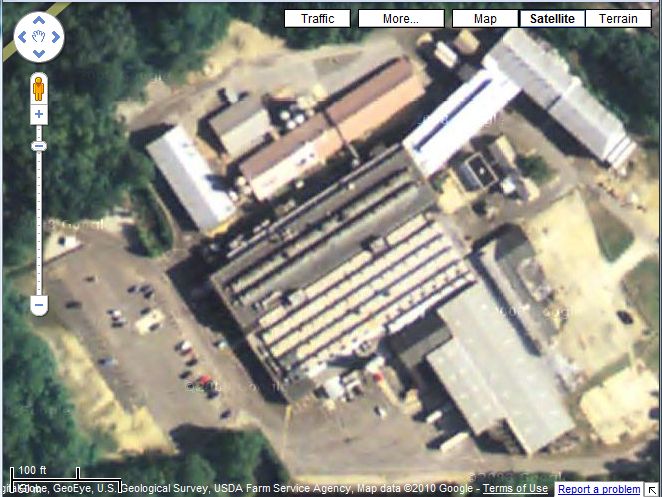
Top screenshot is an NJGIN file in Globalmapper, bottom is NJPB maps at max zoom

Again, just follow the directions I gave above. The files on the NJGIN site are the same imagery as the NJPB Live Maps 2007 aerials, but you can zoom in much farther and they are georeferenced, so you can make files for your GPS from them very easily.
I'm sure there is other software, probably even free software, that can open these files. But Globalmapper just makes it really easy.
Top screenshot is an NJGIN file in Globalmapper, bottom is NJPB maps at max zoom
For comparison, here's the best that google can do...
Here's the location of these examples: http://maps.njpinebarrens.com/#lat=39.40197076100892&lng=-75.0479507446289&z=17&type=nj2007&gpx=
In my first example above (the NJGIN file in Globalmapper), notice that you can even see the lines that are painted in the parking lot.
Here's the location of these examples: http://maps.njpinebarrens.com/#lat=39.40197076100892&lng=-75.0479507446289&z=17&type=nj2007&gpx=
In my first example above (the NJGIN file in Globalmapper), notice that you can even see the lines that are painted in the parking lot.
Boyd
yes the imagery is better,not quite good enough to find stones from my desktop but still better the google earth
would be real nice if they offer imagery taken in winter.
Al
yes the imagery is better,not quite good enough to find stones from my desktop but still better the google earth
would be real nice if they offer imagery taken in winter.
Al
i can get as far as outlining the area i want with a polygon but absolutely nothing appears on the right.i can get rid of the help file on right and still nothing appears there but more map.i cannot download anything because the files do not appear when i highlight the tiles so that there is nothing to put in the shopping cart.
Al
Al
When drawing a polygon, keep clicking your mouse to define each corner. When you have drawn the shape you want, DOUBLE-CLICK, then the squares should be selected and the list will appear on the right. I suppose it could also be a browser issue - it works for me using Firefox on the PC and Safari on the Mac though.
As a simpler test, use the pencil icon "Select by Point". When you use this tool, you only need to click ONCE on the square that you want. It should appear in the pane on the right side of the window. If this works, then you will know that it isn't a browser problem. But my guess is that you have not double-clicked to finish drawing the polygon.
-Boyd
I have got as far as this screen.can't figure out how to download these to computer,if they are already downloaded i can't find them.once i get them on computer i can download global mapper and open them as you say but can't seem to actually get them onto the computer.
Al
I
Al
I
Al: you are almost there...
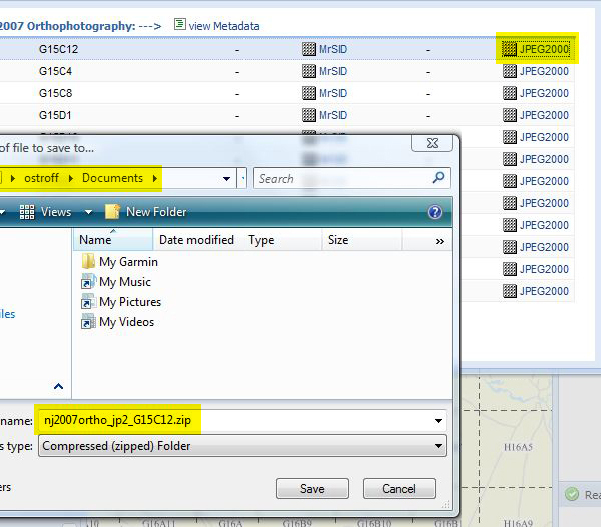
In this example I clicked on the JPEG2000 link of the first file on the list. This will download the file in JPEG2000 format. You could also use MrSID, which is an alternate format. To me, the JPEG2000 files have looked a little better I think (different compression schemes).
This gives you a window in Firefox asking where you want to save the file. You can make a folder in advance if you like, or just save to your documents folder or the desktop. Clicking the Save button will place a file named NJ2007ortho_jp2_G15C12.zip in the location you chose.

Now this is dependent on setting your browser properly. In Firefox, go to Tools > Options and you can choose the behavior you want. I have configured it to always ask before saving, so I won't get confused as to where the files are going. But you could also choose just one place for everything to automatically go if you prefer.
In this example I clicked on the JPEG2000 link of the first file on the list. This will download the file in JPEG2000 format. You could also use MrSID, which is an alternate format. To me, the JPEG2000 files have looked a little better I think (different compression schemes).
This gives you a window in Firefox asking where you want to save the file. You can make a folder in advance if you like, or just save to your documents folder or the desktop. Clicking the Save button will place a file named NJ2007ortho_jp2_G15C12.zip in the location you chose.
Now this is dependent on setting your browser properly. In Firefox, go to Tools > Options and you can choose the behavior you want. I have configured it to always ask before saving, so I won't get confused as to where the files are going. But you could also choose just one place for everything to automatically go if you prefer.
Boyd
ok I got the tiles onto my computer and then tried to dowload global mapper the 64 bit version and the global 11 trial version and both said that windows has found a problem with this file.i have vista so i am going to retry as admin but it probably won't help.vista is notoriously bad for stuff like this,at least for me.i will give it one more try.
Al
Boyd
I got it to work! the imes you put up here were buildings wich really didn't sow thi thing off to it's fll potential.now th I can see into the woos n the winter no less i can almost see some of the larger stones! This is great.The prices they advertise are quite high.is this a one time fee or per year? I just sent for a registration key,is this good for one month? I can no doubt get the barrens in that amount of time but may swing the whole price if it's a one time fee.
thanks alot for your patience,if i can convert these into rmp files through triton rmp then this will be much better then the google earth maps I've been making.
Thanks again!
Al